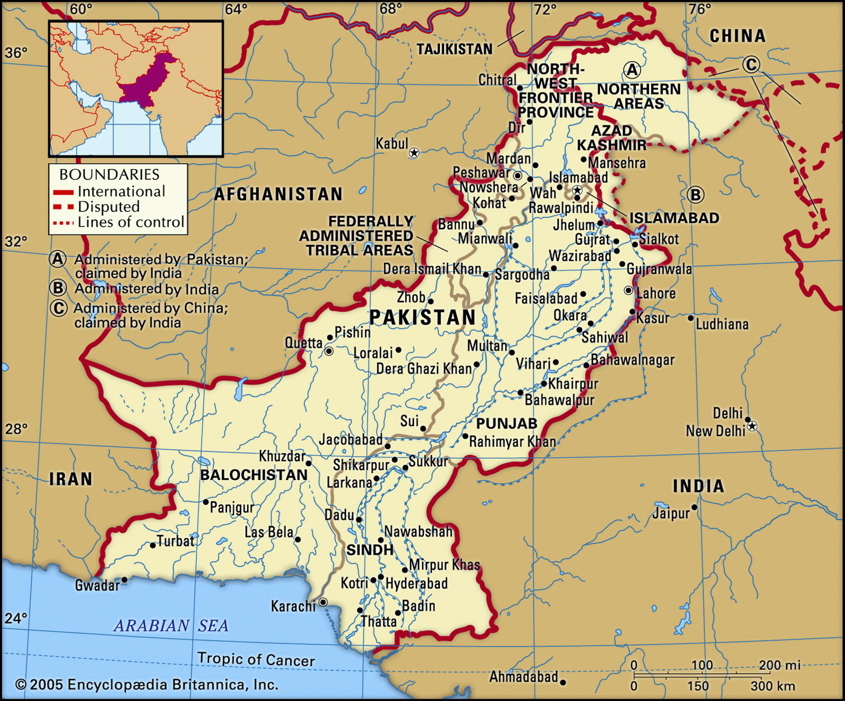
Map of Pakistan and geographical facts
Where Pakistan on the world map. Map of Pakistan
Map of Pakistan with cities. Where Pakistan is on the world map. The main geographical facts about Pakistan - population, country area, capital, official language, religions, industry and culture.

Pakistan Fact File
Official name Islamic Republic of Pakistan
Form of government Republic with two legislative bodies (Senate and National Assembly)
Capital Islamabad
Area 803,940 sq km (310,401 sq miles)
Time zone GMT+ 5 hours
Population 147,664,000
Projected population 2015 204,267,000
Population density 183.7 per sq km (475.7 per sq mile)
Life expectancy 61.8
Infant mortality (per 1,000) 78.5
Official languages Urdu
Other languages Punjabi, Sindhi, Urdu, Pashto, Baluchi, Brahvi, English
Literacy rate 42.7%
Religions Muslim 97% (Sunni 77%, Shi'a 20%), other (Christian, Hindu) 3%
Ethnic groups Punjabi 50%, Sindhi 15%, Pashtun (Pathan) 15%, Mohajir (Indian immigrants and their descendants) 8%, Baloch 5%, other 7 %
Currency Pakistani rupee
Economy Agriculture 50%, services 38%, industry 12%
GNP per capita US$ 2,100
Climate Mainly arid; temperate in northwest, cold and snowy in mountains
Highest point K2 8,611 m (28,251 ft)
Map reference Page 221
Pakistan occupies the valley of the Indus and its tributaries in the northwest of the Indian subcontinent. Its most sensitive political frontiers are with India to the east and Afghanistan to the west. It has shorter borders with Iran and China.
A part of India until 1947, Pakistan shares with it a history of early civilizations, migrations, and invasions—farmers in the Indus Valley were already using elaborate irrigation works by the second millennium вс. At the time of partition in
1947, Pakistan was two widely separated territories (West and East Pakistan). A dispute over Kashmir has poisoned relations with India since that time. In 1971 East Pakistan achieved independence as Bangladesh. In that year the populist leader Ali Bhutto assumed power in Pakistan, and in 1973 announced a program of "Islamic socialism" under which banks, insurance companies, heavy industry, and even education were nationalized. Since 1977, when he was overthrown by General Zia ul-Haq (and subsequently executed), military and civilian rule have alternated, accompanied by varying degrees of violence and disorder.
Although 97 percent of Pakistan's population is Muslim, there is a wide range of ethnic groupings, languages, and conflicts. The main linguistic separation is between Iranian languages such as Baluchi and Pashto on one hand, and the Indo-Aryan languages of Punjabi, Sindhi, and Urdu on the other. Each of Pakistan's minorities has its own particular concerns. In the northwest of the country the Pathans want to join their kinsmen over the Afghan frontier. The Urdu-speaking Mohajirs migrated by the millions from India at the time of partition and make up the majority of the population in Karachi and Hyderabad. They resent Punjabi domination and the rule of the old land-owning elite.
The whole of Pakistan is drained by the Indus River. Rising in the Great Highlands of the north it flows southwest, joined by tributaries such as the Jhelum, Chenab, Beas, Ravi, and Sutlej, and forms a fertile and densely populated floodplain in the east of the country before spilling into the Arabian Sea. The waters of this basin feed into one of the largest irrigation systems in the world, the total area being 13 million hectares (32 million acres). Two constructions, one at Tarbela on the Indus, and the other at Mangla on the Jhelum, are among the world's biggest earth-and rock-filled dams. West of the Indus delta is an ascending landscape of alternating ridges and arid basins, some containing salt marshes like the Hamun-i-Mashkel. In the extreme northwest are the Great Highlands, with the Khyber Pass on the frontier with Afghanistan to the west and the spectacular peaks of the Karakoram and Pamirs to the east. Along with Nanga Parbat, these include the second highest mountain in the world—K2, Mt Godwin Austen (8,611 m; 28,251 ft) on the border of Tibet.
Irrigation agriculture combined with the new plant varieties that were introduced as part of the "green revolution" during the 1970s produces abundant cotton, wheat, rice, and sugarcane. Fruit and vegetables are also grown widely, while opium poppies and cannabis are illegally cultivated to supply the international drug trade. Despite the fact that approximately half the population work on the land, agriculture now accounts for less than a quarter of the national income.
Karachi is a considerable manufacturing center for the production of textiles, as is Lahore. Other industries produce a wide variety of petroleum products, construction materials, foodstuffs, and paper products. The country has large reserves of unused minerals: copper, bauxite, phosphates, and manganese. However, Pakistan also faces a range of problems. The country's economy is dependent on the highly competitive textile sector, there is a chronic trade deficit and debt burden, and much of the nation's revenue goes into funding massive defense spending on items such as nuclear weaponry and the army.