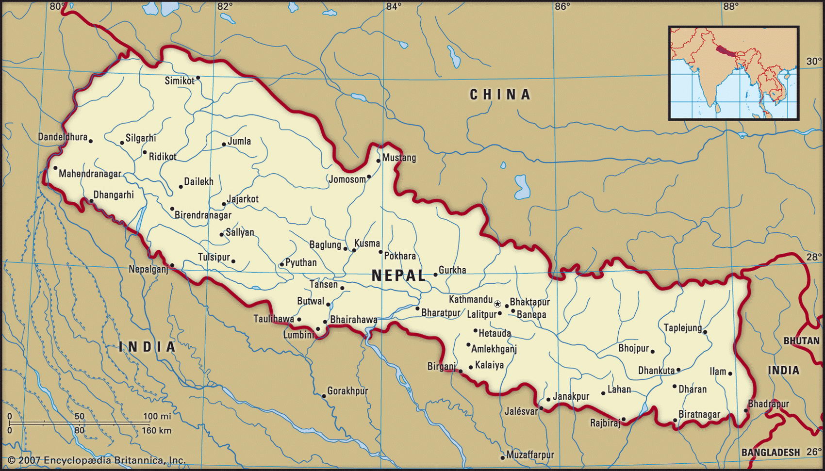
Map of Nepal and geographical facts
Where Nepal on the world map. Map of Nepal
Map of Nepal with cities. Where Nepal is on the world map. The main geographical facts about Nepal - population, country area, capital, official language, religions, industry and culture.

Nepal Fact File
Official name Kingdom of Nepal
Form of government Constitutional monarchy with two legislative bodies (National Council and House of Representatives)
Capital Kathmandu
Area 140,800 sq km (54,363 sq miles)
Time zone GMT + 5.5 hours
Population 25,874,000
Projected population 2015 32,1 38,000
Population density 183.8 per sq km (475.9 per sq mile)
Life expectancy 58.6
Infant mortality (per 1,000) 72.4
Official language Nepali
Other languages Indo-Aryan languages (among them Maithili and Bihari), Tibeto-Burmese languages (including Tamang, Newari)
Literacy rate 27.5%
Religions Hindu 90%, Buddhist 5%, Muslim 3%, other 2 %
Ethnic groups Nepalese 52%, Maithili 11 %, Bhojpuri 8%, Tamang 4%, Newari 3%, others 22 %
Currency Nepalese rupee
Economy Agriculture 93%, services 6%, industry 1 %
GNP per capita US$ 1,400
Climate Subtropical in south, with wet season July to October; cold and snowy in north, wetter in east
Highest point Mt Everest 8,848 m (29,028 ft) Map reference Pages 218-19
The birthplace of the Buddha in с. 568 вс, Nepal is a small landlocked kingdom on the southern slopes of the Himalayas. It is surrounded by India to the west, south, and east, and has a border with China (Tibet) to the north. Tourists coming to trek in the mountains and climb the peaks contribute to national income, but Nepal remains one of the world's poorest countries. Historically, it was influenced both by the Buddhist/Mongol culture of Tibet and by the Hindu/Indian culture of the subcontinent. The present royal family established its rule in 1769. During British colonial rule in India a British resident was installed to provide "guidance" in foreign affairs. In 1959 the country's first elections were held (the Nepali Congress party winning), but in I960 the king suspended the constitution, and no further elections were held until 1992. In the late 1990s a parliamentary impasse existed: neither the Nepali Congress nor the United Marxist-Leninist (UML) parties had clear majorities enabling them to govern in their own right. On June 1, 2002, the king and nine of his family members were killed in a massacre. His brother and successor is trying to introduce a more liberal system in the country.
The mountainous heart of Nepal, consisting of the towering Himalayas (including the highest and third-highest peaks in the world, Mt Everest and Kanchenjunga) and the lower Siwalik Range to the south, covers three-quarters of the country. Three main river systems cut the Himalayas, the Karnali (feeding the Ganges), the Gandak, and the Kosi. Kathmandu stands among fruit trees and rice fields typical of Nepal's densely populated uplands. Further south, on the Terai/ Ganges Plain, farming settlements grow rice, wheat, maize, sugarcane, and jute which are the country's economic maintstay.
Some ninety percent of Nepalis live by subsistence farming, and many do not live well: more than forty percent of Nepal's citizens are undernourished. Most industry is concerned with the processing of jute, sugarcane, tobacco, and grain. Recently textile and carpet production has expanded and now provides 85 percent of foreign exchange earnings. The country has limitless hydropower resources. Electricity could be sold to Indian industry south of the border, and various schemes have been proposed, but environmental considerations weigh against them. Restructuring is needed. International aid funds 62 percent of Nepal's development budget and 34 percent of total budgetary expenditure.