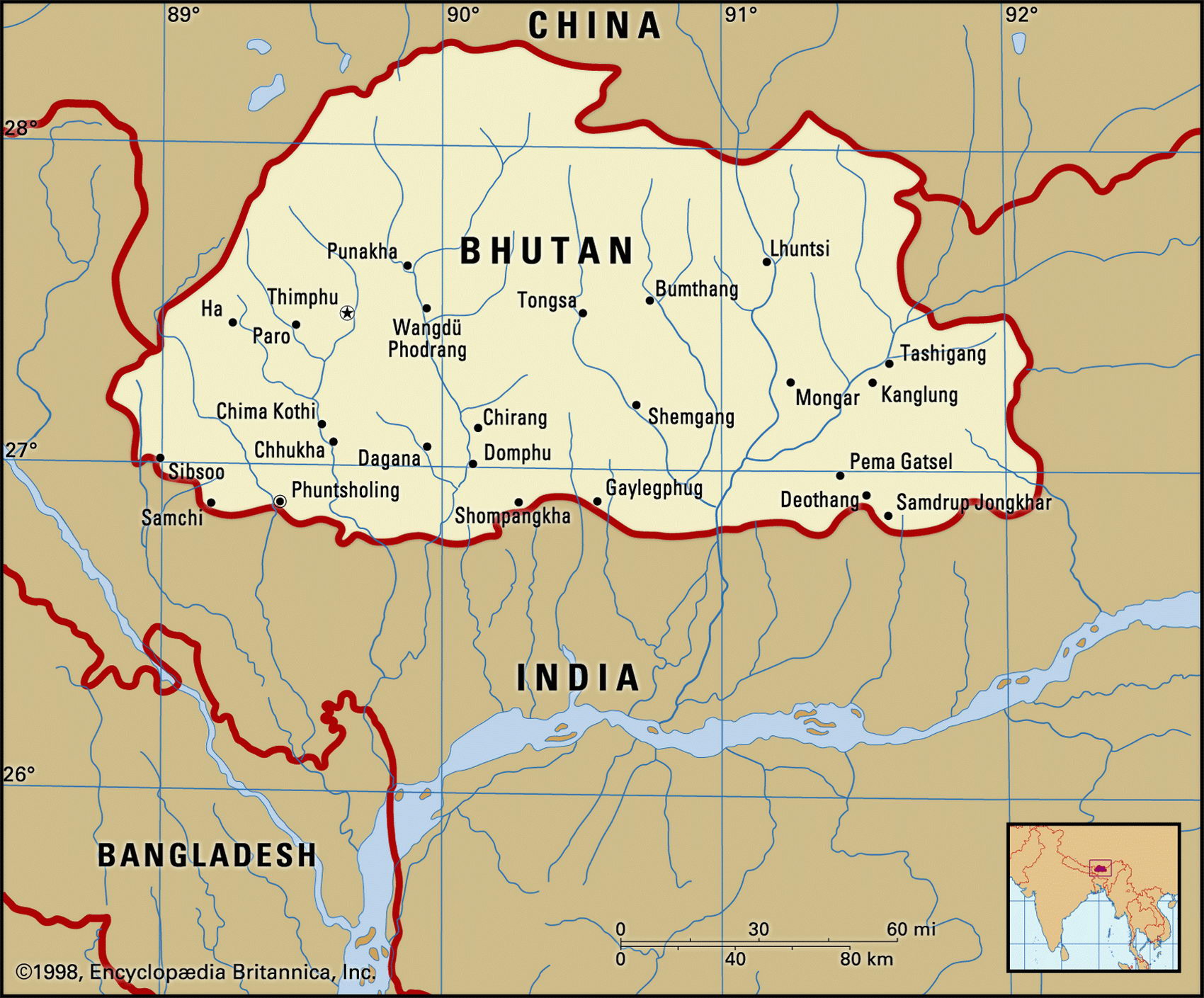
Map of Bhutan and geographical facts
Where Bhutan on the world map. Map of Bhutan
Map of Bhutan with cities. Where Bhutan is on the world map. The main geographical facts about Bhutan - population, country area, capital, official language, religions, industry and culture.

Bhutan Fact File
Official name Kingdom of Bhutan
Form of government Monarchy with single legislative body (National Assembly)
Capital Thimphu
Area 47,000 sq km (18,147 sq miles)
Time zone GMT+ 5.5 hours
Population 2,094,000
Projected population 2015 3,070,000
Population density 44.6 per sq km (115.4 per sq mile)
Life expectancy 53.2
Infant mortality (per 1,000) 106.8
Official language Dzongkha
Other languages Tibeto-Burmanese (among them Bumthangkha, Sarchopkha, Tsangla) and Indo-Aryan languages (including Nepalese)
Literacy rate 42.2%
Religions Lamaistic Buddhism 75%, Hinduism 25%
Ethnic groups Bhote (Tibetan) 50%, ethnic Nepalese 35%, indigenous or migrant tribes 15%
Currency Ngultrum
Economy Agriculture 93%, services 5%, industry and commerce 2%
CNP per capita US$ 1,200
Climate Tropical on southern plains; cool winters and hot summers in central valleys; cold winters and cool summers in mountains
Highest point Kula Kangri 7,553 m (24,780 ft)
Map reference Page 219
Atiny landlocked kingdom nestling in the Himalayas between India and Tibet, Bhutan is difficult to visit, and remains largely closed to the outside world. It is the world's most "rural" country, with less than six percent of its population living in towns and over ninety percent dependent on agriculture to make their living. Despite its isolation and apparent tranquillity, the country is torn by fierce, long-standing ethnic tensions which its absolute monarch does little to mitigate. Bhutan's longest-resident ethnic group consists of the Tibetans who probably migrated there 1,000 years ago. Early in the twentieth century, in order to end continual fighting between rival warlords in the area, the British administration in neighboring India established a hereditary monarch in Bhutan, the "Dragon King", in 1907.
The monarch is head of both the state and the government. Though the current king is a modernizer, intent on changing Bhutan's feudal ways, his emphasis on a sense of national identity founded on the language, laws, and dress of his own Drukpa group has stirred up bitter opposition among the resident Hindu Nepalese in southern Bhutan. Many have been deported, and others have fled to refugee camps in southeast Nepal. Dzongkha, which has been proclaimed the official language of the country, is the natural language of only sixteen percent of Bhutan citizens. In 1998 the king announced that in the future Bhutan's rulers would have to step down if they received a no-confidence vote from the National Assembly.
There are three main regions distinguished largely by altitude—the Great Himalayas, crowned by enormous peaks along the border with Tibet; the slopes and fertile valleys of the Lesser Himalayas, which are divided by the Wong, Sankosh, Tongsa and Manas Rivers; and the Duars Plain which opens out towards India from the foothills of the mountains. The central uplands and foothills are cultivated with food staples including maize, wheat, barley, and potatoes. This area supports the greatest portion of the population. Below this the Duars Plain falls away into broad tracts of semitropical forest, savanna, and bamboo jungle. Forests still cover nearly 75 percent of Bhutan's land area, and timber is both exported to India and used in Bhutan itself as fuel.
Almost all trade is with India. As an export, timber is outweighed in importance by cement. Other revenue-earning activities include a closely supervised and limited tourist industry (visitors are restricted to 4,000 per year), as well as the sale of stamps. Bhutan has tremendous hydropower potential, but most manufacturing is of the cottage-industry type. Development projects such as road construction rely to a alrge extent on Indian migrant labor. Though stabilized at a low level (the economy is one of the world's smallest and poorest) the country's balance of payments is strong, with comfortable reserves.
Mt Everest and surrounding peaks in Nepal (below). Villagers on a suspension bridge in northern Pakistan (right page top). The road between Quetta in Pakistan and the border with Iran (right page bottom).