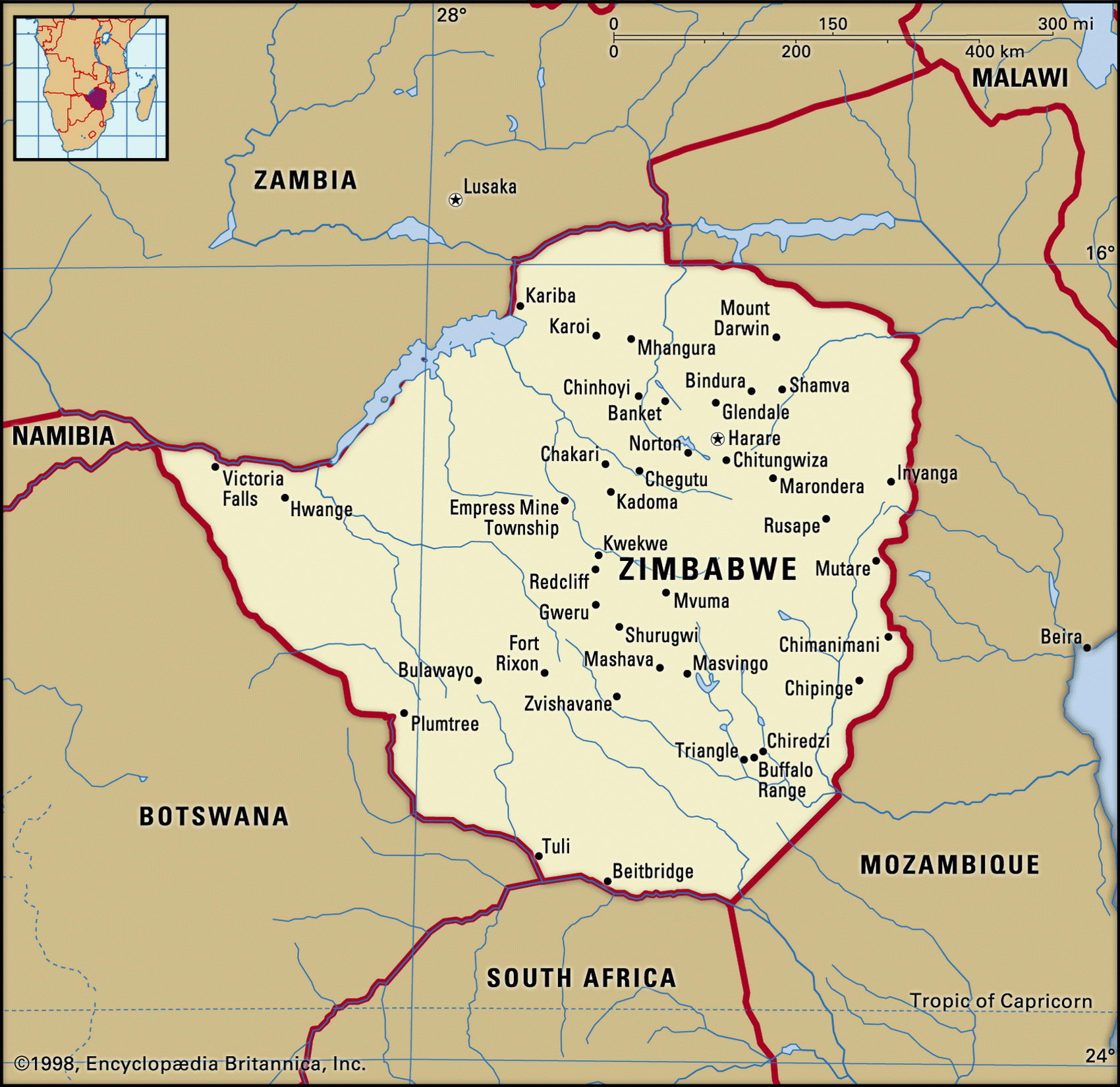
Map of Zimbabwe and geographical facts
Zimbabwe on the world map. Map of Zimbabwe with cities
Map of Zimbabwe with cities. Where Zimbabwe is on the world map. The main geographical facts about Zimbabwe - population, country area, capital, official language, religions, industry and culture.

Zimbabwe Fact File
Official name Republic of Zimbabwe
Form of government Republic with single legislative body (Parliament)
Capital Harare
Area 390,580 sq km (150,803 sq miles)
Time zone GMT + 2 hours
Population 11,377,000
Projected population 2015 16,338,000
Population density 29.1 per sq km (75.4 per sq mile)
Life expectancy 36.5
Infant mortality (per 1,000) 63.0
Official language English
Other languages Shona, Ndebele
Literacy rate 85 %
Religions Mixed Christian-indigenous beliefs 50%, Christian 25%, indigenous beliefs 24%, Muslim and other 1 %
Ethnic groups Indigenous 98% (Shona 71 %, Ndebele 16%, other 11 %), European 1 %, other 1 %
Currency Zimbabwean dollar
Economy Agriculture 65%, services 29%, industry 6 %
GNP per capita US$ 2,450
Climate Tropical, moderated by altitude; wet season November to March
Highest point Inyangani 2,592 m (8,504 ft)
Map reference Page 371
Zimbabwe is a landlocked country south of Zambia. Zimbabwe means "house of the chief" in the Shona language and refers to what are known as the Great Ruins, built by Bantu peoples in the country's south and thought to date from the ninth century ad. The country's two main tribes today, the minority Ndebele (popularly known as Matabele) and the majority Shona, arrived as nineteenth-century fugitives from the warlike expansion of the Zulus under King Shaka.
British settlement began in the 1890s, and there were 280,000 whites in the country in 1965 when their leader, Ian Smith, declared independence from the UK. African guerrilla action to overthrow Smith led to black majority rule in 1980. Since then the government has been led by Robert Mugabe, a Shona. Though he renounced Marxism-Leninism in 1991, and market reforms are on the agenda, during the 1990s Zimbabwe has edged closer to being a de facto one-party state. After the introduction of more democratic measures Mugabe returned to a more and more dictatorial style of government. In order to strengthen his position in 2000 he forced white farmers from their land and redistributed it to his followers. The elections for parliament in 2001 as well as the presidential elections of 2002 were rigged, ignoring international protest. Opposition and labor groups launched general strikes in 2003 to pressure Mugabe to retire but security forces continued their brutal repression of opponents.
Some 25 percent of the country consists of a broad mountainous ridge known as the High Veld, which crosses the country southwest to northeast. On the northeastern Mozambique border it climbs to the peak of Inyangani. The rolling plateaus of the middle veld fall gently away north and south of this central upland, reaching the riverine low veld regions near the Limpopo River in the south and the Zambeze in the north. On the northern border the Zambeze plunges over Victoria Falls into a number of gorges. The falls, with Lake Kari-ba further downriver, along with several national parks, are among Zimbabwe's principal tourist attractions. Almost forty percent of electricity needs are met by hydroelectric power, much of it from the Kariba Dam facility shared with Zambia.
Zimbabwe's near self-sufficiency in food is a by-product of the trade boycotts and economic isolation imposed on the white minority regime of Ian Smith after 1965. This forced both agriculture and manufacturing to diversify. African farms are still mainly small-scale subsistence operations, growing maize, cassava, and wheat. Large-scale enterprises produce most of the cash crops such as tobacco, cotton, and sugarcane, and earn much of agriculture's 35 percent share of national export revenue. Zimbabwe's mineral resources include coal, chromium, asbestos, gold, nickel, copper, iron, vanadium, lithium, tin, and platinum. Mining employs only five percent of the workforce, but minerals and metals account for about forty percent of exports.