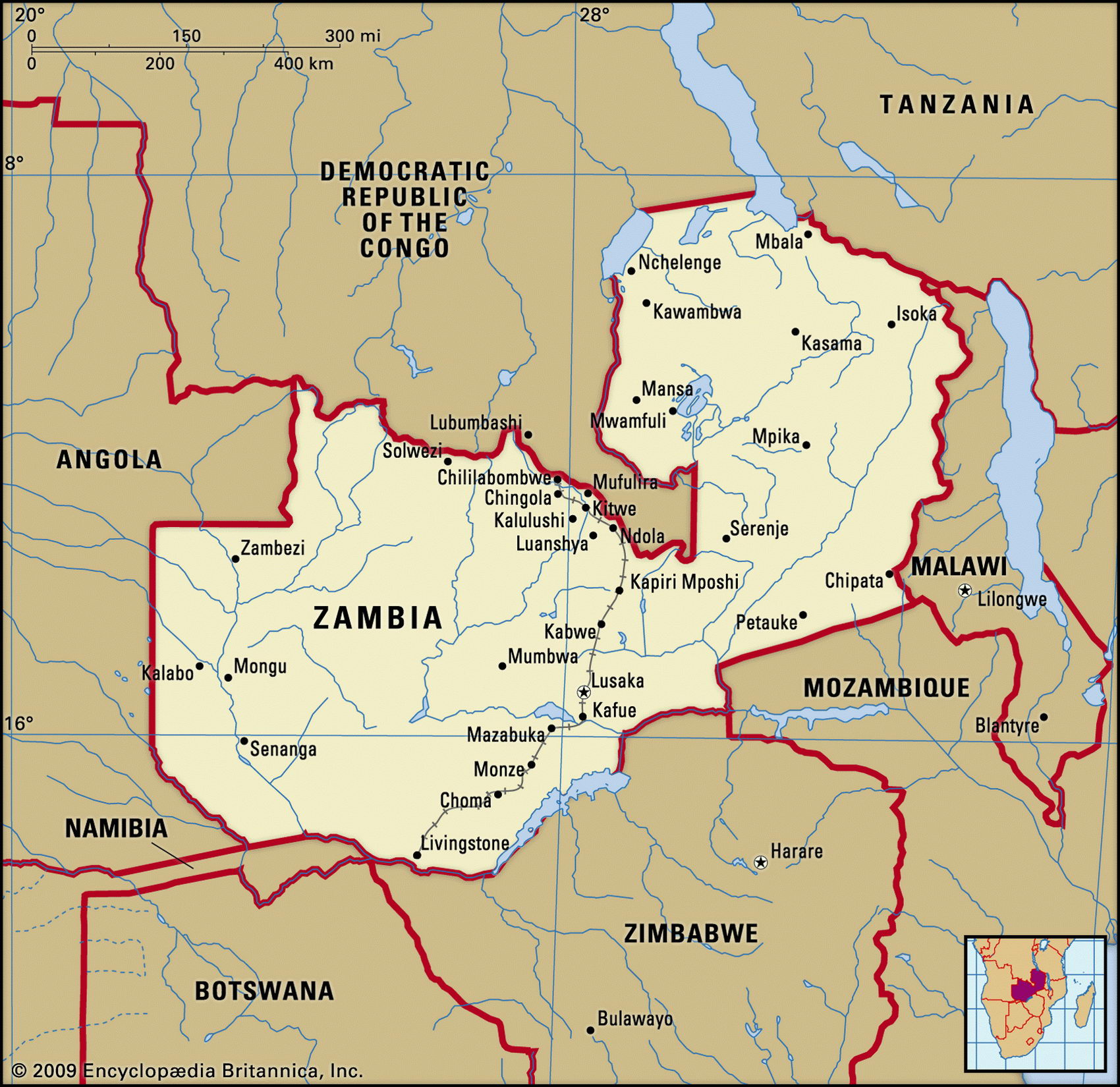
Map of Zambia and geographical facts
Zambia on the world map. Map of Zambia with cities
Map of Zambia with cities. Where Zambia is on the world map. The main geographical facts about Zambia - population, country area, capital, official language, religions, industry and culture.

Zambia Fact File
Official name Republic of Zambia
Form of government Republic with single legislative body (National Assembly)
Capital Lusaka
Area 752,610 sq km (290,583 sq miles)
Time zone GMT + 2 hours
Population 9,960,000
Projected population 2015 14,796,000
Population density 13.2 per sq km (34.3 per sq mile)
Life expectancy 37.3
Infant mortality (per 1,000) 89.4
Official language English
Other languages About seventy indigenous languages including Bemba, Kaonda, Lozi, Lunda, Luvale, Nyanja, Tonga
Literacy rate 78.9 %
Religions Protestant 84 %, Hindu 35%, Roman Catholic 26%, other including Muslim as well as indigenous beliefs 5%
Ethnic groups Indigenous 98.7%, European 1.1 %, other 0.2%
Currency Kwacha
Economy Agriculture 85%, services 9%, industry 6<-
GNP per capita US$ 870
Climate Tropical, with three seasons: cool and dry May to August, hot and dry August to November, wet December to April
Highest point Mafinga Hills 2,301 m (7,549 ft)
Map reference Pages 368-69, 370-71
Zambia is a landlocked country in south-central Africa. It stretches from Victoria Falls in the south to Lake Tanganyika in the north, and is one of the world's major copper producers. Ancestral branches of the Zambian Tonga first entered the area in the eighth century ad, but other African groups now living there are more recent arrivals—the Ngoni and Kololo came as fugitives from Zulu aggression in 1835. Formerly a British colony, and once known as Northern Rhodesia, Zambia became independent in 1964. From that year it was ruled for more than a quarter of a century by President Kaunda, who nationalized commerce and industry and built a one-party socialist state. In 1991, economic decline and political agitation led to Zambia's first free elections. Kaunda was defeated, but even though international observers criticized irregularities in the elections of 1996 and 2001 it looks like democracy prevails. Currently opposition groups hold a majority of the seats in the National Assembly. Since 2002 a large-scale anti-corruption campaign has been in place.
A wide expanse of high plateau broken by scattered mountains and valleys, Zambia is drained by the Zambeze in the west and south, where the river forms a boundary with Zimbabwe and Namibia. Below Victoria Falls the Zambeze is dammed at the Kariba Gorge to form one of the largest artificial lakes in the world, Lake Kariba. Power from the Lake Kariba hydroelectric station is shared with Zimbabwe. Another major river, the Luangwa, runs southwest from the Malawi border down a broad rift valley to join the Zambeze at the frontier of Mozambique.
Compared with its neighbors, Zambia has a high ratio of urban dwellers who are dependent on the rural sector for food. Commercial farming of maize in the central districts, and other food crops such as sorghum and rice, is proving insufficient to meet their needs. This situation has been aggravated both by drought and the phasing out of agricultural subsidies.
Zambia is dependent on copper production, which accounts for over eighty percent of export earnings. Production is down, however, and so are world copper prices, which is intensifying the difficulties caused by high inflation and shrinking internal food supplies. In the post-Kaunda years there has been some attempt at privatization and budgetary reform, but this has produced little improvement. In 1995 four of Zambia's twenty banks failed. Most export earnings go towards paying off the 7 billion dollar external debt— itself to some extent a product of bureaucratic misuse of funds.