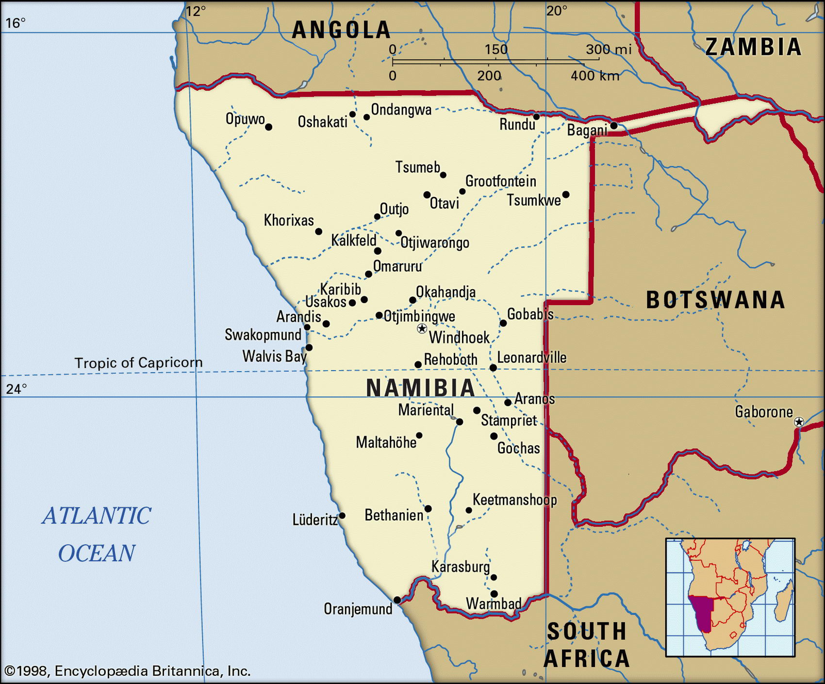
Map of Namibia and geographical facts
Namibia on the world map. Map of Namibia
Map of Namibia with cities. Where Namibia is on the world map. The main geographical facts about Namibia - population, country area, capital, official language, religions, industry and culture.

Namibia Fact File
Official name Republic of Namibia
Form of government Republic with two legislative bodies (National Council and National Assembly)
Capital Windhoek
Area 825,418 sq km (318,694 sq miles)
Time zone GMT + 2 hours
Population 1,821,000
Projected population 2015 2,313,000
Population density 2.2 per sq km (5.7 per sq mile)
Life expectancy 39
Infant mortality (per 1,000) 72.4
Official language English
Other languages Afrikaans, German, indigenous languages
Literacy rate 38.0%
Religions Christian 85% (Lutheran at least 50%, other Christian denominations 35%), indigenous beliefs 15%
Ethnic groups Indigenous tribes 86% (including Ovambo 50%, Kavangos 9%, Herero 7%, Damara 7%), mixed indigenous-European 7.4%, European 6.6%
Currency Namibian dollar
Economy Agriculture 60%, industry and commerce 19%, services 8%, government 7%, mining 6%
GNP per capita US$ 4,500
Climate Mainly arid, with higher rainfall inland
Highest point Konigstein 2,606 m (8,550 ft) Map reference Page 370
Alarge, arid country in southwest Africa, Namibia was born of the European scramble for colonies in the nineteenth century. The German connection with the area (formerly South West Africa) began with the arrival of missionaries in the 1840s. Namibia was a German protectorate from 1884; the scene of a brutal German punitive action in 1904 in which the Herero were decimated—approximately 60,000 were killed—and scattered; under South African control for many years; and endured 23 years of a bitter anti-colonial war that began in 1966. In 1989 an election gave the guerrilla movement SWAPO (the South West African People's Organization) victory at the polls, and in 1990 came independence.
The virtually uninhabited sand dunes of the Namib Desert fringe the country's south Atlantic coastline. A major escarpment inland separates the desert from a north-south range of mountains that includes the Tsaris Mountains, Auas Mountains, and Mt Erongo. The interior plateau, which occupies the eastern part of the country, has an average elevation of 1,500 m (5,000 ft) and is covered with the dry scrub grassland typical of the Kalahari Desert. Largely rainless, the coast is often shrouded in fog. Here, welwitschia plants, some of them up to 2,000 years old, live by absorbing moisture from the fog that rolls in from the sea. Namibia's wildlife is typical of southern Africa, with Etosha National Park providing sanctuary for baboon, antelope, elephant, giraffe, zebra, and lion.
Namibia's natural resources include diamonds, copper, uranium (world's fifth largest producer), gold, lead (world's second largest producer), tin, lithium, cadmium, zinc, vanadium, and natural gas, and there are thought to be deposits of oil, coal, and iron ore. Mining accounts for 25 percent of gross domestic product, this sector relying on the expertise of Namibia's small white population. More than half its African peoples depend on agriculture for a livelihood, working poor soils in an unfavorable climate. Livestock farmers produce beef and mutton. About half the country's food is imported, mainly from South Africa.
High-rise buildings in Pretoria, the South African capital (below). An elephant browsing in Kruger National Park (right page).