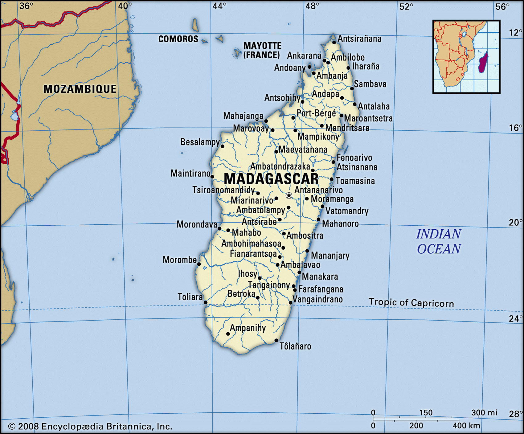
Map of Madagascar and geographical facts
Madagascar on the world map. Map of Madagascar
Map of Madagascar with cities. Where Madagascar is on the world map. The main geographical facts about Madagascar - population, country area, capital, official language, religions, industry and culture.

Madagascar Fact File
Currency Malagasy franc
Official name Republic of Madagascar
Form of government Republic with two legislative bodies (Senate and National Assembly)
Capital Antananarivo
Area 587,040 sq km (226,656 sq miles)
Time zone GMT + 3 hours
Population 16,474,000
Projected population 2015 24,072,000
Population density 28.1 per sq km (72.7 per sq mile)
Life expectancy 55.7
Infant mortality (per 1,000) 81.9
Official languages Malagasy, French
Literacy rate 80 %
Religions Indigenous beliefs 52%, Christian 41 %, Muslim 7%
Ethnic groups Chiefly Malayo-lndonesian inland (including Merina, Betsileo, Betsimisaraka) and mixed African, Arab, Malayo-lndonesian on coasts (including Tsimihety, Sakalava) 99%; other 1%
Economy Agriculture 81 %, services 13%, industry 6%
GNP per capita US$ 870
Climate Tropical in coastal regions; temperate inland (wet season November to April); arid in south
Highest point Maromokotro 2,876 m (9,436 ft)
Map reference Page 372
Larger than France, Madagascar is the world's fourth largest island. Located off the southeast coast of Africa, it contrasts sharply with the African mainland in its wildlife, people, culture, language, and history. In the center and the east live the Merina or Hova people who migrated to the island from the islands now known as Indonesia about 2,000 years ago. By the nineteenth century the Merinas, with their capital in Tanarive, ruled much of the country. In 1896 the island became a French colony. It won independence from France in I960, following a bloody insurrection. From 1975 it was run as a one-party socialist state associated with the Soviet Union. In 1992 riots and mass demonstrations caused by deepening poverty forced the introduction of a multi-party democracy with elections in 1997 and 2002. The latter were contested and challenged legally and decided in court.
To the east the land drops precipitously to the Indian Ocean through forests dissected by rushing streams. Inland lies the mountainous central plateau, accounting for sixty percent of the island's total area, and rising in several places above 2,500 m (8,200 ft). Various geological eras are represented in the island's rugged topography, which features steep faulting, volcanic outcrops, and deep-cut valleys. On the western slopes of the plateau the land falls away more gently to broad and fertile plains. In the central highlands both the landscape and agriculture have a south Asian character, as rice farming is combined with raising cattle and pigs. Land usage is more African in style on the east coast and in the northern highlands, with fallow-farming of food crops such as cassava and maize, and the cultivation of coffee, sugar, and spices for export.
Separated from the African mainland for over 50 million years, Madagascar developed its own distinctive wildlife: three-quarters of the flora and fauna are found nowhere else. The island is known for its 28 species of lemur—dainty, large-eyed primates—and for the tenrec, a small, spiny, insect-eating mammal. Many of the island's 1,000 or so orchid species are endemic, and it is home to half the world's chameleon species.
Among the poorest countries in the world, Madagascar is not self-sufficient in food. The main staples are rice and cassava, but production is failing to keep pace with an annual population growth rate of around three percent. Additional problems derive from past government initiatives. When collective farming was introduced in 1975 it resulted in falling production and widespread resentment. Since 1993 corruption and political instability have accompanied economic confusion and a decay in the infrastructure.
Looking toward Silhouette Island in the Seychelles (left page top). Antananarivo, the capital of Madagascar (center). A street scene in Toliara, Madagascar (right).