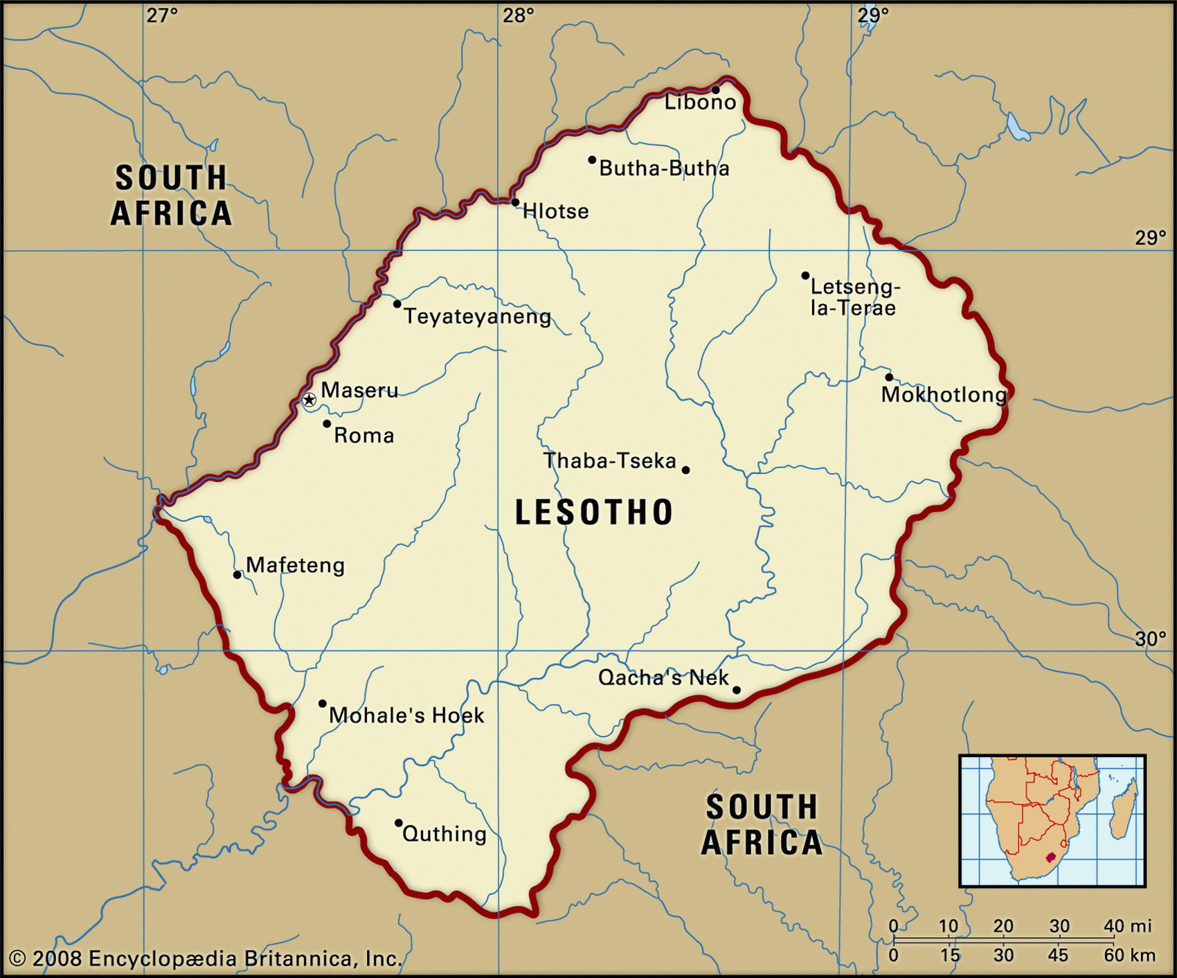
Map of Lesotho and geographical facts
Lesotho on the world map. Map of Lesotho
Map of Lesotho with cities. Where Lesotho is on the world map. The main geographical facts about Lesotho - population, country area, capital, official language, religions, industry and culture.

Lesotho Fact File
Official name Kingdom of Lesotho
Capital Maseru
Time zone GMT + 2 hours
Population 2,208,000
Currency Loti
GNP per capita US$ 2,450
Form of government Constitutional monarchy with two legislative houses (Senate and National Assembly)
Area 30,350 sq km (11,718 sq miles)
Projected population 2015 2,621,000
Population density 72.8 per sq km (188.4 per sq mile)
Life expectancy 47
Infant mortality (per 1,000) 82.6
Official languages Sesotho, English
Other languages Zulu, Afrikaans, French, Xhosa
Literacy rate 83%
Religions Christian 80%, indigenous beliefs 20%
Ethnic groups Sotho 99.7%, European and Asian 0.3%
Economy Agriculture 73 %, services and industry 27%
Climate Temperate, with cool, dry winters and hot, wet summers
Highest point Thabana-Ntlenyana 3,482 m (11,424 ft)
Map reference Page 371
Lesotho is a small landlocked country entirely surrounded by South Africa. Formerly the British Protectorate of Basutoland, it is the only country in the world where all the land is higher than 1,000 m (3,300 ft). About two-thirds of the terrain is mountainous, and at higher altitudes it often snows throughout the winter. As the head of a fragile constitutional monarchy, the king of Lesotho has no executive or legislative powers: traditionally, he could be elected or deposed by a majority vote of the College of Chiefs. Proposals to unite Lesotho with post-apartheid South Africa have been resisted by members of the population who feel an independent state will better defend their cultural heritage. In 1998, violent protests and a military mutiny following a contentious election prompted a brief but bloody South African military intervention. Constitutional reforms have since restored political stability; peaceful parliamentary elections were held in 2002.
A high mountainous plateau declining from east to west, Lesotho's highest ridges were formed on basaltic lavas. Treeless, with steep valleys, the wet highlands are soft and boggy in summer and frozen in winter. Numerous river valleys and gorges dissect the plateau, among them the River Orange. To the northwest the border of the country is defined by the Caledon River. This is flanked by a 30 to 65 km (18 to 40 mile) strip of fertile land which supports most of Lesotho's farmers and provides the bulk of its agriculturally useful land. Subsistence crops include maize, sorghum, wheat, and beans. Sheep and goats are kept for wool and mohair on the high plateau.
Lesotho is without important natural resources other than water. Hopes are held for the future of a major hydroelectric facility, the Highlands Water Scheme, which will sell water to South Africa and become a major employer and revenue earner. The scheme will supply all of Lesotho's energy requirements. In scattered hamlets, cottage industry produces woven mohair rugs. Manufacturing based on farm products consists of milling, canning, and the preparation of leather and jute. Roughly sixty percent of Lesotho's male wage earners work across the border in South Africa, mostly as laborers in mines. The wages they send back provide some 45 percent of domestic income.