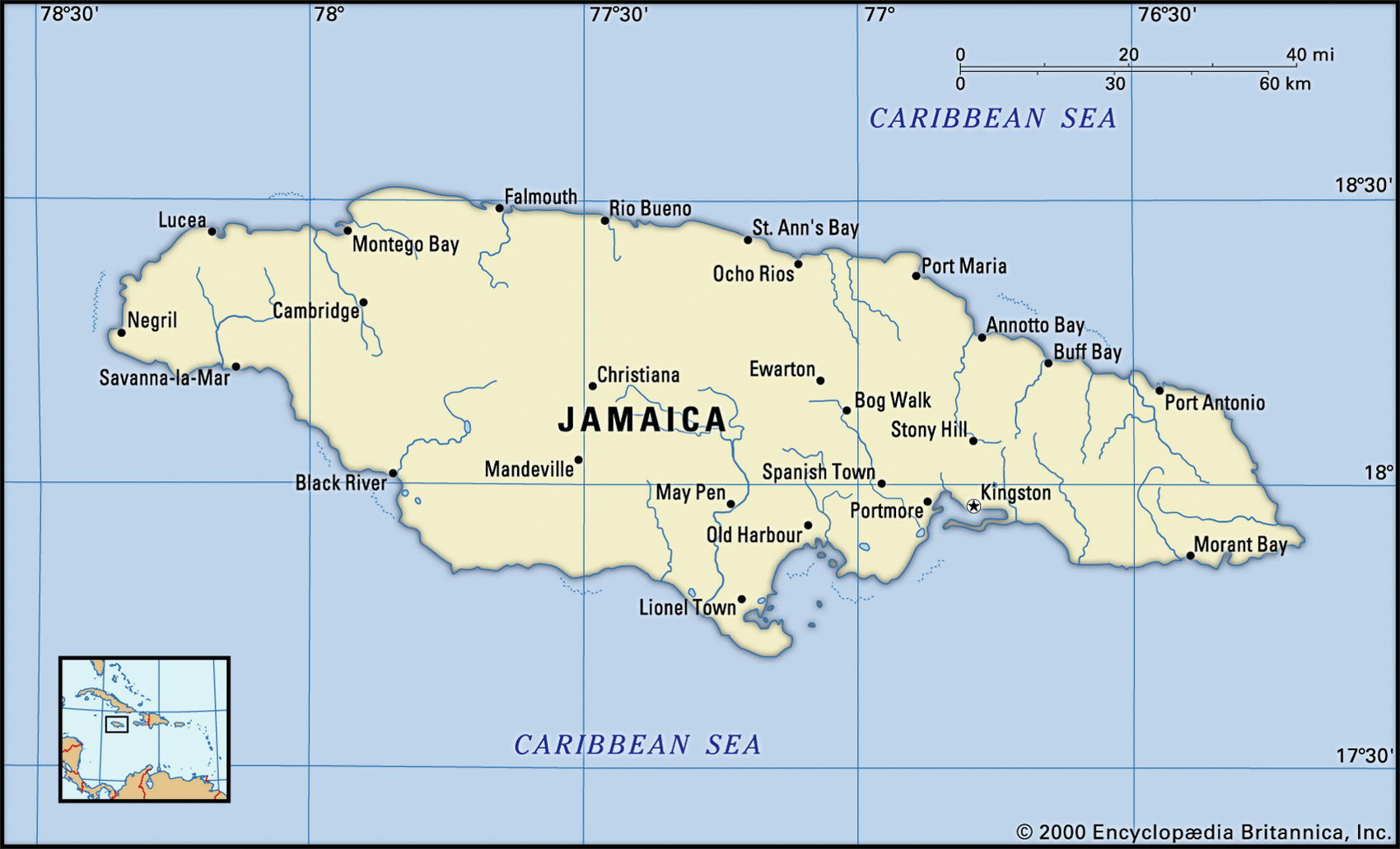
Map of Jamaica and geographical facts
Map of Jamaica with cities. Jamaica on the world map
Map of Jamaica with cities. Where Jamaica is on the world map. The main geographical facts about Jamaica - population, country area, capital, official language, religions, industry and culture.

Jamaica Fact File
Official name Jamaica
Capital Kingston
Time zone GMT - 5 hours
Population 2,680,000
Official language English
Other language Creole
Literacy rate 85c
Currency Jamaican dollar
Economy Services 63%, industry 12%, agriculture 25%,
GNP per capita US$ 3,700
Climate Tropical; cooler inland
Form of government Constitutional monarchy with two legislative bodies (Senate and House of Representatives)
Area 10,990 sq km (4,243 sq miles)
Projected population 2015 2,957,000
Population density 243.9 per sq km (631.6 per sq mile)
Life expectancy 75.6
Infant mortality (per 1,000) 13.7
Religions Protestant (mainly Anglican, Presbyterian-Congregational, Baptist, Methodist) 70%, Roman Catholic 7%, other including Rastafari 23%
Ethnic groups African 76.3%, mixed African-European 15.1 %, East Indian and mixed African-East Indian 3%, European 3.2%, Chinese and mixed African-Chinese 1.2%, other 1.2%
Caribbean
Highest point Blue Mountain Peak 2,256 m (7,402 ft)
Map reference Page 429
The Caribbean island of Jamaica lies 144 km (98 miles) south of Cuba and southwest of Haiti. Mountainous in the interior, it is the most populous of the English-speaking Caribbean islands. Arawak Indians were its first inhabitants. Columbus visited in 1494 and a slave-based sugar producing plantation society was established by the British after they seized the island in 1655. It won independence from Britain in 1962. An important contributor to world music, Jamaica is the home of reggae, a style originating in Kingston's tough urban environment. Also from Jamaica come the Rastafarians, followers of the one-time Emperor of Ethiopia. In September 1988 Jamaica was devastated by the fiercest hurricane to strike the island this century, causing widespread loss of life and leaving twenty percent of the people homeless.
In the northwest of the island is a limestone area of steep ridges and isolated basins, pitted with sink-holes. This "cockpit country" once gave refuge to escaped slaves. In the east the land rises to become the densely forested Blue Mountains. In the west the River Black is navigable upstream for about 30 km (19 miles). Sugar plantations dominate the densely populated and extensively cultivated lowland coastal fringe. Seasonal rains fall most heavily on the northeastern mountain slopes—still covered in the rainforest once found all over the island. In the rainshadow of the mountains, the southern lowlands support only savanna scrub.
Bauxite has been mined since 1952. Most of it is exported as ore, and about one-fifth as alumina, making Jamaica the world's third-largest producer. This accounts for more than fifty percent of exports. Tourism and bauxite production are Jamaica's two main industries, and comprise almost two-thirds of foreign earnings. Other export industries include printing, textiles and food processing, along with rum distilling and sugar production. In agriculture, sugarcane and bananas are the main cash crops, along with coffee, cocoa, and fruit. In recent years the government has removed most price controls and privatized state enterprises. Unemployment remains high. Jamaica's medium-term prospects depend largely on its ability to attract foreign capital and limit speculation against the Jamaican dollar.