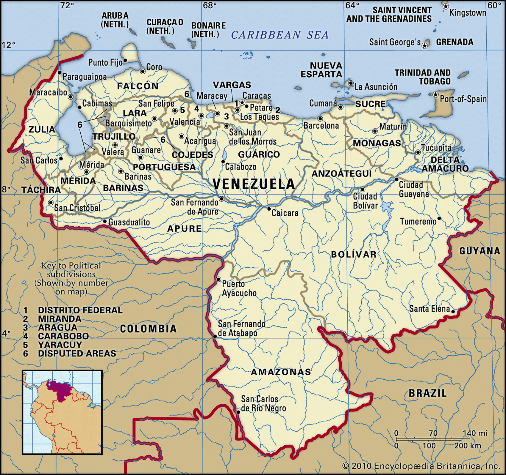
Map of Venezuela and geographical facts
Venezuela is the world map. Map of Venezuela
Map of Venezuela with cities. Where Venezuela is on the world map. The main geographical facts about Venezuela - population, country area, capital, official language, religions, industry and culture.

Venezuela Fact File
Official name Republic of Venezuela
Form of government Federal republic with two legislative bodies (Senate and Chamber of Deputies)
Capital Caracas
Area 912,050 sq km (352,142 sq miles)
Time zone GMT-4 hours
Population 24,288,000
Projected population 2015 30,877,000
Population density 26.6 per sq km (69 per sq mile)
Life expectancy 73.6
Infant mortality (per 1,000) 24.6
Official language Spanish
Other languages Indigenous languages
Literacy rate 91.1 %
Religions Roman Catholic 96%, Protestant 2 %, other 2 %
Ethnic groups Mixed indigenous-European 67%, European 21 %, African 10%, indigenous 2%
Currency Bolivar
Economy Services 63 %, industry 25 %, agriculture 12 %
GNP per capita US$ 6,100
Climate Tropical, with dry season December to April; cooler in highlands
Highest point Pico Bolivar 5,007 m (16,427 ft)
Map reference Pages 450-51
Venezuela is on the north coast of South America. When the first Spaniards arrived in 1499 they named it "New Venice" because the Indian stilt houses built in the water of Lake Maracaibo reminded them of the Italian city. The liberator Simon Bolivar was a Venezuelan general, the military campaign he led resulting in the country becoming independent in 1821. For the next century Venezuela's economy was largely based on agriculture, but in the 1920s it took a new direction with the development of a petroleum industry. In the last eighty years great wealth (unevenly shared) followed by industrialization have produced one of Latin America's most urbanized societies. Out of every twenty Venezuelans, seventeen are city-dwellers, and migration from the countryside left much of the interior depopulated.
Confident that oil revenues would never end, the Venezuelan government expanded the economic role of the state, even buying hotels. Falling oil prices in the early 1980s produced a fiscal crisis, and in 1991 a program of cutbacks and austerity measures triggered street riots in which hundreds died. Two attempted coups took place during 1992. Since that time there has been a concerted effort to achieve economic diversification and to cut back the state sector. In 1999 a new constitution was installed to create more stability, but a short-lived coup in 2002 and fights between government forces and opposition in 2003 shook the country.
The hot lowlands surrounding Lake Maracaibo in the far northwest comprise one of the areas of greatest population density. In this region abundant electricity from oil-fired generators provides power for light industry: food processing, pharmaceuticals, electrical equipment, and machinery. A spur of the northern Andes divides the Maracaibo Basin from the drainage system of the Orinoco to the east. Here are the lowland plains of the Llanos, savanna country used for cattle grazing. Much of the Llanos floods during the summer rains, especially in the west, though it is dry for the rest of the year. To the south is the vast granite plateau of the Guiana Highlands, and the highest waterfall in the world—Angel Falls (979 m; 3,212 ft).
Despite fluctuations in oil prices, petroleum continues to provide over seventy percent of Venezuela's export earnings and 45 percent of government revenue. Other minerals exported include iron ore, gold, and diamonds. The main cash crops are coffee, sugarcane, and tobacco; food crops include bananas, sorghum, and maize. Only five percent of arable land is cultivated, and agriculture supplies little more than seventy percent of the country's needs. In the 1990s, economic reforms proposed by the IMF were rejected by the president, who responded by defending exchange controls and other regulatory measures.