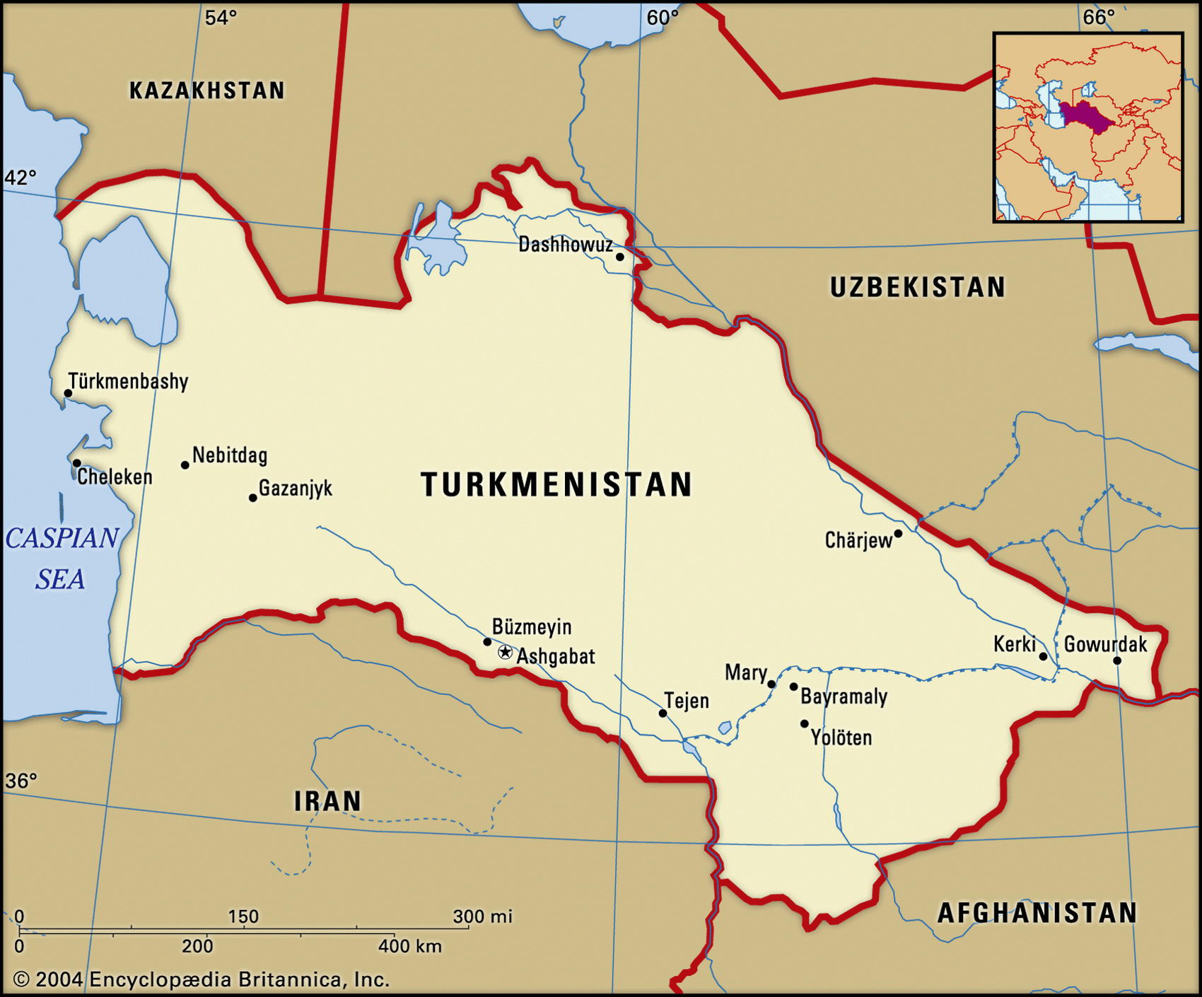
Map of Turkmenistan and geographical facts
Turkmenistan on the world map. Map of Turkmenistan
Map of Turkmenistan with cities. Where Turkmenistan is on the world map. The main geographical facts about Turkmenistan - population, country area, capital, official language, religions, industry and culture.

Turkmenistan Fact File
Region Central and West Asia
Official name Republic of Turkmenistan
Form of government Republic with single legislative body (Parliament)
Capital Ashgabat
Area 488,100 sq km (188,455 sq miles)
Time zone GMT + 5 hours
Population 4,689,000
Projected population 2015 6,059,000
Population density 9.6 per sq km (24.9 per sq mile)
Life expectancy 61.1
Infant mortality (per 1,000) 73.2
Official language Turkmen
Other languages Russian, Uzbek
Literacy rate 98 %
Religions Muslim 87%, Eastern Orthodox 11 %, other 2%
Ethnic groups Turkmen 73.3%, Russian 9.8%, Uzbek 9 %, Kazak 2 %, other 5.9 %
Currency Manat
Economy Agriculture 44%, services 36%, industry 20%
GNP per capita US$4,700
Climate Mainly arid, with cold winters and hot summers
Highest point Ayrybaba 3,139 m (10,298 ft) Map reference Page 222
Turkmenistan is in southern Central Asia. From the Caspian Sea it stretches east to Afghanistan, and borders Iran to the south. Kazakhstan and Uzbekistan lie to the north. The Turkmen are probably descended from the same tribes as the Seljuk and Ottoman Turks who conquered what is now Turkey in the eleventh century. Russia annexed Turkmenistan in 1884 and began colonizing it in 1906. In 1924 it became the Turkmen Soviet Socialist Republic. Fierce local resistance to Sovietization continued into the 1930s and there were mass arrests of cultural and religious leaders. Turkmenistan declared its independence in 1991 but little has changed politically. It remains a one-party state and the first secretary of the former Communist Party is now the president, elected with a 99-5 percent share of the vote. The chief difference is that the government can now seek outside capital to develop the country's vast natural gas reserves, and looks to Muslim countries rather than Russia for support.
More than ninety percent of the country is arid, the greater part of it being the Kara Kum Desert. Most of the Kara Kum is made up of the plains of the Krasnovodskoye Plato, but ten percent consists of huge sand dunes. In the east the Amu Darya River forms part of the Afghanistan border. This river once fed the Aral Sea but from the 1950s much of its water was diverted into the Kara Kum Canal which crosses two-thirds of the country westward to Kizyl-Arvat (Gyzlar-bat). This provided irrigation for cotton, but also helped dry up the Aral Sea. To the west of the plateau the land falls to the Caspian shore.
Turkmenistan is poor, despite its natural gas and oil reserves. Half its irrigated land is planted in cotton but industrial development has been limited. Apart from Astrakhan rugs and food processing, industry is largely confined to mining sulfur and salt, and natural gas production. Through 1995 inflation soared, and falling production saw the budget shift from a surplus to a deficit. Since independence in 1991 there have been few changes in economic policy, leading to growing poverty and a shortage of basic foods. Cotton and grain harvests were disastrous in 1996 and desertification remains a serious problem.