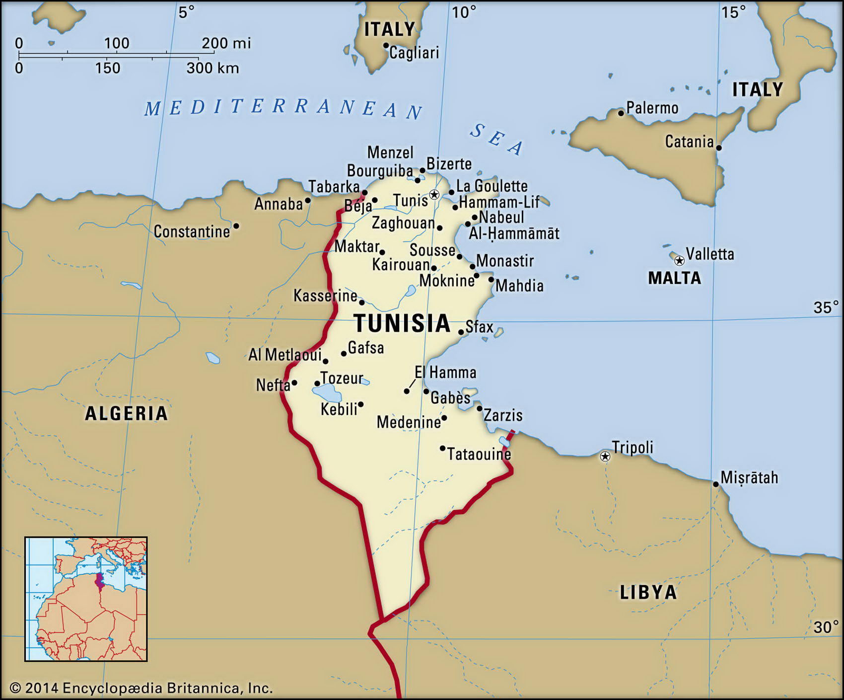
Map of Tunisia and geographical facts
Tunisia on the world map. Map of Tunisia
Map of Tunisia with cities. Where Tunisia is on the world map. The main geographical facts about Tunisia - population, country area, capital, official language, religions, industry and culture.

Tunisia Fact File
Official name Republic of Tunisia
Form of government Republic with single legislative body (Chamber of Deputies)
Capital Tunis
Area 163,610 sq km (63,170 sq miles)
Time zone GMT + 1 hour
Population 9,816,000
Projected population 2015 11,257,000
Population density 60 per sq km (155.4 per sq mile)
Life expectancy 74.2
Infant mortality (per 1,000) 28.0
Official language Arabic
Other language French, Berber languages
Literacy rate 66.7%
Religions Muslim 98%, Christian 1 %, Jewish 1 %
Ethnic groups Arab-Berber 98%, European 1 %, Jewish 1 %
Currency Dinar
Economy Services 62%, agriculture 22%, industry 16%
North Africa
GNP per capita US$ 6,600
Climate Temperate in north, with mild, rainy winters and hot, dry summers; desert in south
Highest point Jabal ash Sha'nabl 1,544 m (5,065 ft)
Map reference Page 361
Tunisia has a long history. Located in North Africa, across from Sicily, it was founded by Phoenician sailors 3,000 years ago, became famous as the Carthage of Queen Dido, and fell to the Romans in 146 вс. Arab conquest brought Islam to the region in the seventh century ad.
In modern times control of Tunisia was disputed by Italy, England, and France before it became a French protectorate in 1883. Ruled since independence in 1956 as a de facto one-party state, Tunisia held its first multi-party elections in 1994 (the government claiming 99-9 percent of the vote). Tunisia is a relatively prosperous country, strongly influenced by French and European culture, with a record of modest but steady economic growth. While Islamic fundamentalism is on the rise, women are treated with greater equality in Tunisia than elsewhere in the Arab world.
The eastern end of the Atlas Mountains juts across the border from Algeria in the north. A mountainous plateau called the Dorsale extends northeast sloping down to the coastal plains. Parallel to the Mediterranean Sea in the extreme northwest, the Kroumirie Mountains, covered with cork oaks, shelter the fertile valley of the Majardah River as it flows down from the Dorsale. Harnessed for hydroelectric power, this enters the sea near Tunis across broad alluvial lowlands used for growing a wide variety of crops, some extensively irrigated, including wheat and barley, olives, sugar beet, citrus fruits, grapes, and vegetables. South of the mountains a dry expanse of plateau-steppe gives way to a series of salt lakes, the largest, ShaJJ al Jarid, extending halfway across the country. The large remaining area to the south is desert.
Tunisia has a diverse economy. Agriculture is the main employer, but in recent years it has declined in importance as a revenue earner relative to mineral and petroleum exports. Most industrial production is based on agricultural and mining products. Real growth averaged 4.2 percent from 1991 to 1995, with moderate inflation. Growth in tourism has been a key factor. Since the 1960s Tunisia has been a popular destination for European tourists, drawn by winter sunshine, beaches, and Roman remains. In recent times there have been almost 2 million visitors per year, with tourism employing 200,000 people, but the activities of Islamic militants have had a dampening effect.