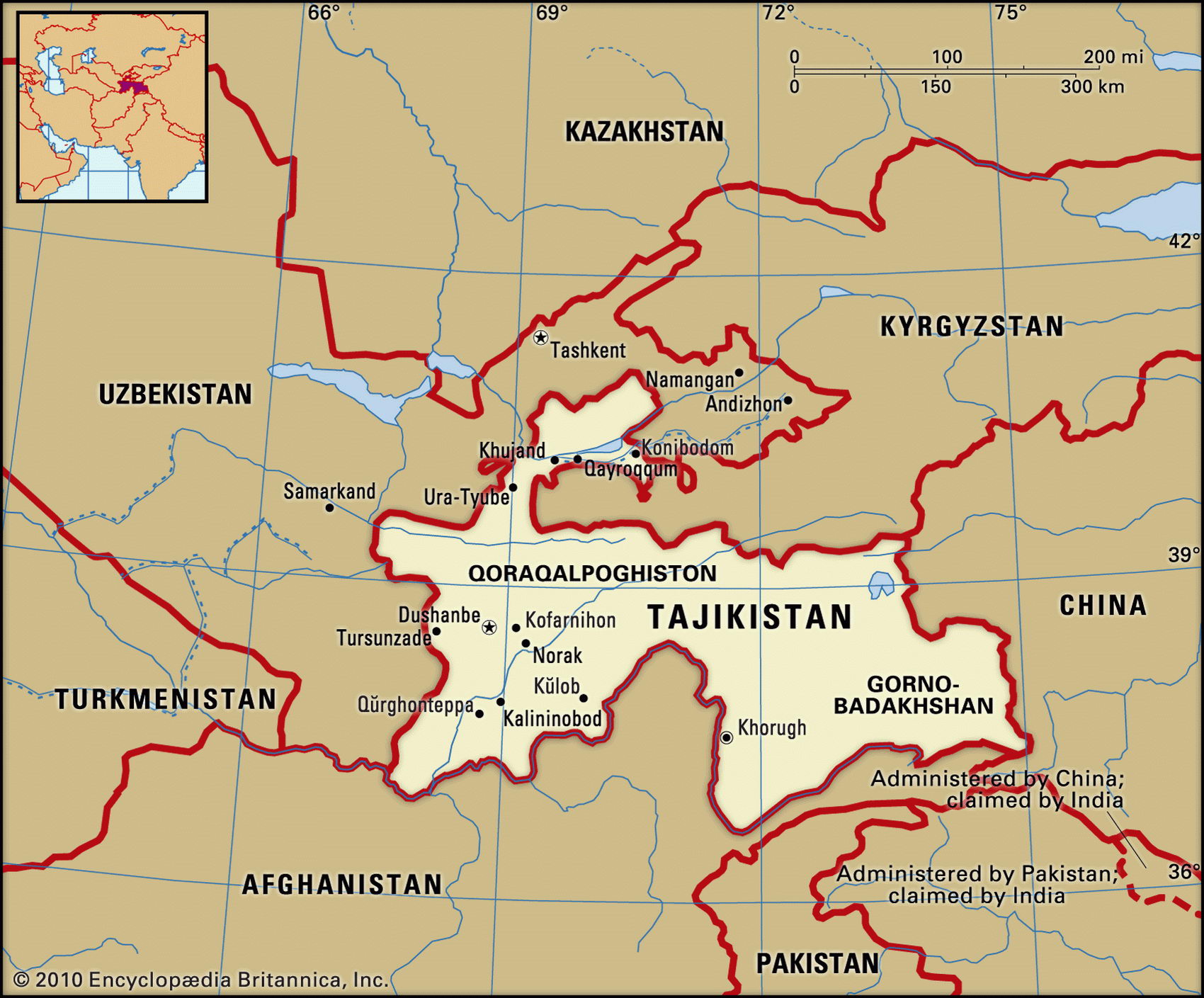
Map of Tadjikistan and geographical facts
Tajikistan on the world map. Map of Tajikistan
Map of Tajikistan with cities. Where Tajikistan is on the world map. The main geographical facts about Tajikistan - population, country area, capital, official language, religions, industry and culture.

Fact File Tajikistan
Official name Republic of Tajikistan
Form of government Republic with single legislative body (Supreme Assembly)
Capital Dushanbe
Area 143,100 sq km (55,251 sq miles)
Time zone GMT + 6 hours
Population 6,720,000
Projected population 2015 7,097,000
Population density 47 per sq km (121.6 per sq mile)
Life expectancy 64.3
Infant mortality (per 1,000) 114.8
Official language Tajik
Other language Russian, Uzbek
Literacy rate 98 %
Religions Sunni Muslim 80%, Shi'a Muslim 5%, other (including Russian Orthodox) 15%
Ethnic groups Tajik 65%, Uzbek 25%, Russian 3.5%, other 6.5%
Currency Tajik ruble
Economy Agriculture 43%, services 35%, industry 22 %
GNP per capita US$ 1,140
Climate Mild winters and hot summers in valleys and on plains, drier and much colder in mountains
Highest point Pik imeni Ismail Samani 7,495 m (24,590 ft)
Map reference Page 223
Tajikistan lies between Uzbekistan, Afghanistan, and China on the western slope of the Pamirs. It also shares a border with Kyrgyzstan to the north. The country is an irregular shape because it was carved out of the Soviet Republic of Uzbekistan on Stalin's orders in 1929. This was intended to deal with Tajik resistance to the Soviet regime, but as it left the two Tajik centers of Samarqand and Bukhoro in Uzbekistan, it merely added another grievance. The Tajiks are Persian-Iranian culturally and linguistically, not Turkic-Mongol like many other peoples of Central Asia. Immigration of both Uzbeks and Russians during the Soviet era caused further resentment. Since independence in 1991 ethnic hostility has resulted in a state of near civil war. Tens of thousands were killed and thousands more have fled to Afghanistan and Kyrgyzstan. Only in 1997 was a peace achieved. It remains a major objective to overcome the destructions of the war.
A long finger of territory in the north contains the only fertile agricultural region. This is the western end of the Fergana Valley through which the Syrdar'ya drains northwest toward the Aral Sea. Cotton is the chief crop, though cereals and fruit are also grown. The region has seen the overuse of pesticides on cotton, and the drying up of the distant Aral Sea has been aggravated by water taken for irrigation. Between this valley and one to the south drained by the Vakhsh stand the Turkestan and Gissar Ranges. This substantial physical divide also corresponds to the political divide between the Uzbek communists in the north and the Islamic secularists in the south. Most of eastern Tajikistan consists of the Pamirs, a part of the Tien Shan Range of western China.
Tajikistan has the second-lowest per capita gross domestic product of any former USSR republic, the fastest growing population, and a low standard of living. Agriculture is the most important sector and cotton the main crop. The country has limited mineral resources, including silver, gold, uranium, and tungsten. Hydropower provides energy for the manufacture of aluminum, cotton textiles and clothing, and for food processing. The economy is weak from years of conflict. Subsidies once provided by the USSR are gone, along with markets—Russia once bought Tajik uranium for its weapons program. Basic subsistence for many people depends on foreign aid. Social instability, plus the continuation of Soviet-era politicians and officials in power, has prevented economic reforms.