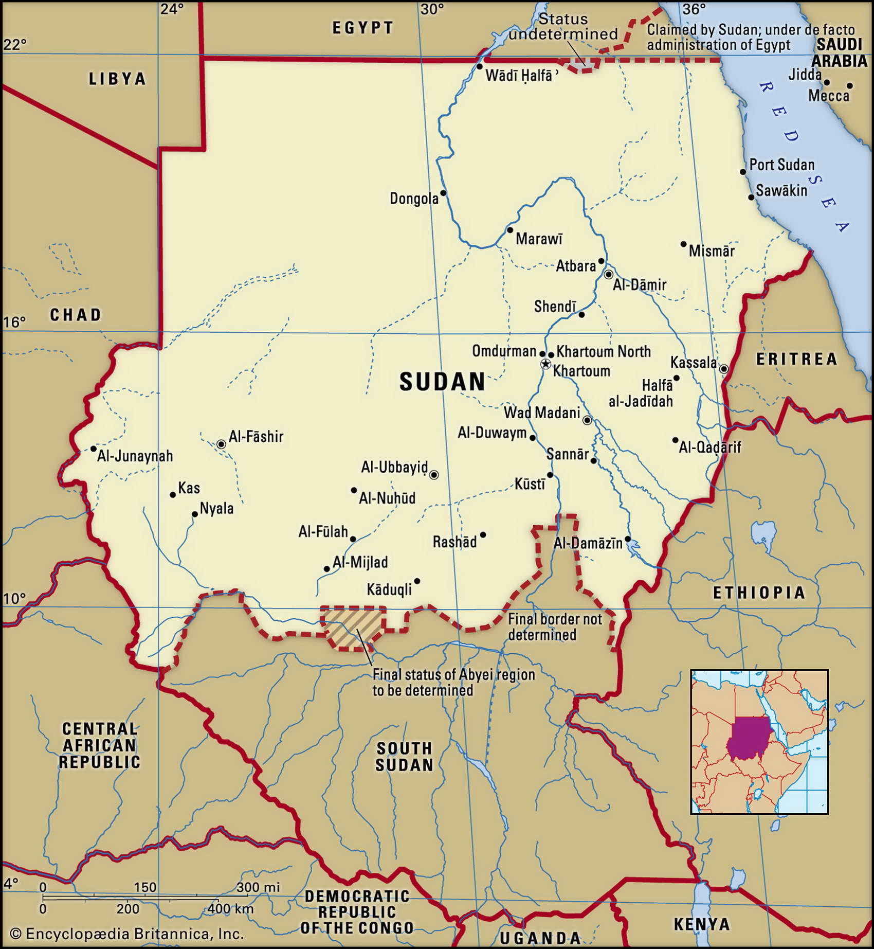
Map of Sudan and geographical facts
Sudan on the world map. Map of Sudan
Map of Sudan with cities. Where Sudan is on the world map. The main geographical facts about Sudan - population, country area, capital, official language, religions, industry and culture.

Sudan Fact File
Official name Republic of the Sudan
Form of government Military regime with single transitional legislative body (Provisional National Assembly)
Capital Al Khartum (Khartoum)
Area 2,505,810 sq km (967,493 sq miles)
Time zone GMT + 2 hours
Population 38,091,000
Projected population 2015 42,433,000
Population density 15.2 per sq km (39.4 per sq mile)
Life expectancy 57.3
Infant mortality (per 1,000) 67.1
Official language Arabic
Other languages Nubian, Та Bedawie, English, indigenous languages
Literacy rate 46.1 %
Religions Sunni Muslim 70%, indigenous beliefs 25%, Christian 5%
Ethnic groups African 52%, Arab 39%, Beja 6%, other 3 %
Currency Sudanese pound
Economy Agriculture 63%, services 33%, industry 4%
GNP per capita US$ 1,360
Climate North mainly arid; south tropical, with wet season April to October
Highest point Mt Kinyeti 3,187 m (10,456 ft)
Map reference Pages 362-63, 366-67
South of Egypt, Sudan is Africa's largest country, and the pathway to the headwaters of the Nile (An Nil). It is also one of Africa's most divided countries. Known in Ancient Egypt as Nubia, its northern region came under Islamic Arab control in the fourteenth century, and Egyptian and British rule in the nineteenth. With some 570 distinct ethnic groups and over 100 languages, it has been difficult for Sudan to form a modern state.
Since achieving independence from Egypt and Britain in 1956 Sudan has seen military rule, coups, and civil conflict for all but ten of the next forty years. The main cause is the determination of the Muslim north to impose Arab and Islamic values on the varied African, animist, and Christian peoples of the south. Strict sharia (Muslim) law has been proclaimed but is widely ignored. After the government's "war of annihilation" against the 1.5 million Nuba people, supported by opposition groups, it has now also turned against the Muslim, but black, population of the Darfur province. Over half a million people have died in the past twelve years, the miseries of the ethnic Africans being compounded by famine, displacement, rape, and the enslavement of women and children. One task of relief workers has been to purchase the freedom of slaves.
In northern Sudan the rocky Sahara Desert stretches westward to become a waste of sand dunes, the land rising to 3,071 m (10,075 ft) at the Darfur Massif toward the border with Chad. In the east the Red Sea Mountains rise 2,000 m (6,500 ft) above a narrow coastal plain. Most people live near the south-north flowing Nile (An Nil), a river that divides into two streams at Khartoum. From here the source of the Blue Nile (Al Bahr al Azraq) can be traced southeast to the Ethiopian border and Lake Tana. The White Nile (Al Bahr al Abyad) runs southwards into the vast marshland of the Sudd (where dense, floating vegetation makes navigation difficult), then further upstream to Uganda and its headwaters in Lake Albert.
About 80 percent of Sudan's workforce are farmers. There is a heavy emphasis on growing cotton, at the expense of food crops, as it accounts for 24 percent of export revenue. Food crops include sorghum (the staple) along with millet, wheat, barley, and peanuts. Declining rainfall and huge displacements of the rural population as a result of war have played havoc with production in recent years. The socialist government is resisting reform: in 1990 the IMF declared Sudan noncooperative because of nonpayment of debts. At present aid comes mainly from Iran. Natural resources include copper, chromium ore, zinc, tungsten, mica, silver, and gold. Some gold is mined.
Crumbling pyramids in the desert at Meroue in the Sudan witness its long common history with Egypt (right).