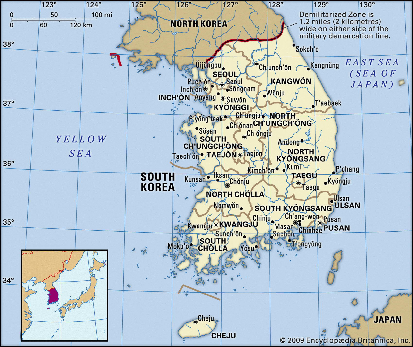
Map of South Korea and geographical facts
South Korea on the world map. Map of South Korea
Map of South Korea with cities. Where South Korea is on the world map. The main geographical facts about South Korea - population, country area, capital, official language, religions, industry and culture.

South Korea Fact File
Official name Republic of Korea
Form of government Republic with single legislative body (National Assembly)
Capital Seoul
Area 98,480 sq km (38,023 sq miles)
Time zone GMT +9 hours
Population 48,324,000
Projected population 2015 50,631,000
Population density 490.7 per sq km (1,270.9 per sq mile)
Life expectancy 74.9
Infant mortality (per 1,000) 7.6
Official language Korean
Other language English, Japanese
Literacy rate 98 %
Religions Christianity 21 %, Buddhism 24%, Confucianism 1.5 %, other 1 %, no religion 52.5 %
Ethnic groups Korean 99.9%, Chinese 0.1 %
Currency Won
Economy Services 55%, industry 27%, agriculture 18%
GNP per capita US$ 19,400
Climate Temperate, with cold winters and hot, wet summers
Highest point Halla-san 1,950 m (6,398 ft) Map reference Page 208
South Korea occupies the southern half of the Korean Peninsula. The border between South and North Korea consists of the ceasefire line established at the end of the Korean War (1950-53), roughly corresponding to the original pre-1950 border at the 38th parallel. The kingdom of Korea was dominated by either China or Japan for many centuries and finally annexed by Japan in 1910. After Japan's defeat at the end of the Second World War, Korea was divided between a northern Soviet zone of influence, and a southern zone under US control. These zones soon became separate political entities. In 1950 communist North Korea invaded South Korea, and though the war ended in a stalemate in 1953, bitter hostility between north and south endures to the present day, with covert operations continuing.
In the 40-year period following 1953, both Koreas diverged socially, politically, and economically. South Korea, after a few years under the authoritarian rule of its first president, established constitutional liberalism in the Second Republic of I960. From then until his assassination in 1979 it was under the elected presidency of General Park Chung Нее, who laid the basis for the economic success of the modern South Korean state with a combination of state planning and free-market incentives.
While questionable practices flourished at the top (two former presidents have been jailed) the country achieved a remarkable record of growth. Only 30 years ago its standard of living was much the same as the poorer countries of Africa. Today its gross domestic product per capita is nine times India's, fourteen times North Korea's, and on a par with some economies of the European Union. Regionally, its technological and scientific prowess is second only to Japan's.
More than 80 percent of South Korea's terrain is mountainous. Along the eastern side of the country the Tabaek-Sanmaek Mountains descend north to southwest. The Han and Naktong Rivers
drain from these mountains through low-lying plains—the Han to the northwest, the Naktong to the south. Densely populated and intensively farmed, these plains cover 15 percent of South Korea's total land area. Rice, a staple crop in which the country is almost self-sufficient, is grown on family-owned farms. Other food crops include barley and fruit such as apples, grapes, peaches, nectarines, and plums. Silk and tobacco are produced for the export market.
About two-thirds of South Korea is forested. As many as 3,000 small islands lie off the west and south coasts, including Cheju which has South Korea's highest peak, the extinct volcano Halla-san at 1,950 m (6,398 ft).
There is little at the high-tech end of modern industry that South Korea does not manufacture and sell. It produces electronic equipment, machinery, ships, and automobiles. Textiles, an early item in its drive for export success, remain significant, along with clothing, food processing, chemicals, and steel. Real gross domestic product grew by an average of ten percent from 1986 to 1991, then tapered off. With the downturn in the Asian economies in 1998 the economy shrank for the first time in years, but the country won praise from the IMF (International Monetary Fund) for acting promptly in order to wipe out billions in bad bank loans and purge companies that were unviable.
A broad avenue in Seoul, South Korea (above). Rural scenery in South Korea (below). A traditional house in rural japan (right page top). The Cinza district in Tokyo, japan (left).