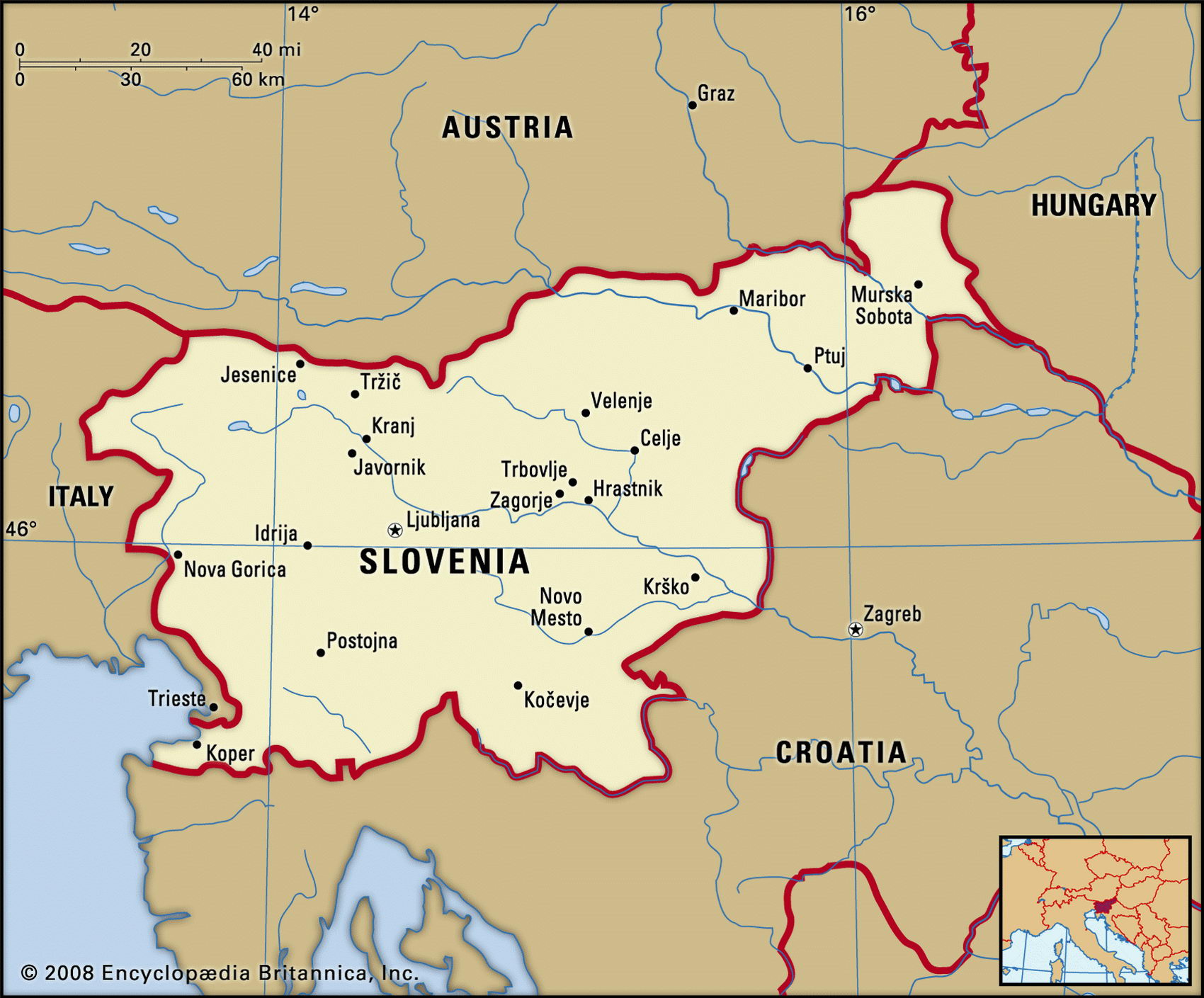
Map of Slovenia and geographical facts
Slovenia on the world map. Map of Slovenia with cities
Map of Slovenia with cities. Where Slovenia is on the world map. The main geographical facts about Slovenia - population, country area, capital, official language, religions, industry and culture.

Slovenia Fact File
Official name Republic of Slovenia
Form of government Republic with two legislative bodies (National Assembly and National Council)
Capital Ljubljana
Area 20,256 sq km (7,821 sq miles)
Time zone GMT + 1 hour
Population 1,933,000
Projected population 2015 1,926,000
Population density 95.4 per sq km (247.2 per sq mile)
Life expectancy 75.3
Infant mortality (per 1,000) 4.5
Official language Slovenian
Other languages Serbian, Croatian, Hungarian, Italian Literacy rate 99 %
Religions Roman Catholic 96%, Muslim 1 %, other 3 %
Ethnic groups Slovene 91 %, Croatian 3%, Serbian 2%, Muslim 1 %, other 3%
Currency Tolar
Economy Services 52 %, industry 46 %, agriculture 2 %
GNP per capita US$ 18,000
Climate Temperate, with colder winters and hotter summers inland
Highest point Mt Triglav 2,864 m (9,396 ft) Map reference Page 294
This former Yugoslav republic shares borders with Italy to the west, Austria to the north, Hungary to the east, and Croatia to the south. The port of Koper on Slovenia's short coastline on the Gulf of Venice is an important transit point for products from Austria and much of Central Europe. First settled by Slavic peoples in the sixth century ad, Slovenia became a Hungarian province in the eleventh century. Austria gained control of the region in the sixteenth century, and Slovenia was later absorbed into the Austro-Hungarian Empire. At the end of the First World War it became part of the Kingdom of the Croats, Serbs, and Slovenes, which in 1929 became Yugoslavia. Like the rest of Yugoslavia, it was occupied by Axis powers during the Second World War. In 1991 it became the first Yugoslav republic to declare its independence. This prompted a military response from the Yugoslav army, which, however, withdrew its forces after a ten-day conflict. According to its constitution of 1991, Slovenia is a democratic republic with a directly elected president and a prime minister as head of the government. Since 2004 it has been a member of the EU.
Slovenia is mountainous, with the highest and most spectacular regions in the Slovenian Alps near the border with Austria in the northwest. Almost half the land is densely forested. There are areas of lowland in the west near the coast and much of the center and east of the country consists of undulating plains. The most fertile region is in the east, where the Drava River flows southward across the Pannonian Plain into Croatia.
Slovenia's tourist industry, based on its alpine scenery and its coastal beaches, remains important, although it has been adversely affected by conflicts in the region. Almost half the workforce is employed in mining and manufacturing industries. Metallurgy and heavy machine manufacture, including trucks and cars, are prominent among these. Textile manufacture is also widespread. The main mineral resource is coal and there are large mercury deposits in the northwest. Dairy farming and pig raising are the main agricultural activities. Slovenia's nuclear power plant, which supplies one-third of the country's electricity, is a cause of some international tension, especially with Austria.