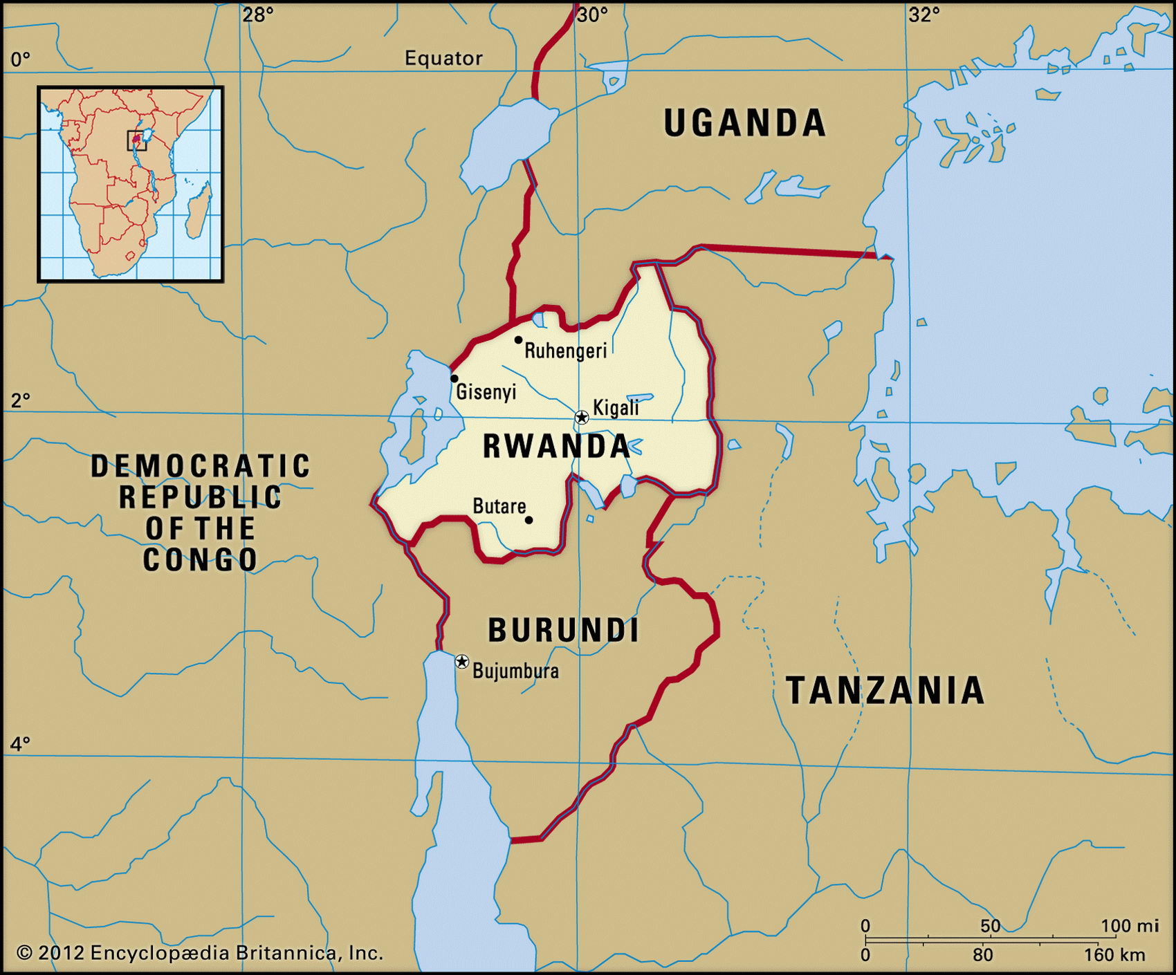
Map of Rwanda and geographical facts
Rwanda on the world map. Map of Rwanda
Map of Rwanda with cities. Where Rwanda is on the world map. The main geographical facts about Rwanda - population, country area, capital, official language, religions, industry and culture.

Rwanda Fact File
Official name Republic of Rwanda
Form of government Republic with transitional legislative body (National Assembly)
Capital Kigali
Area 26,340 sq km (10,170 sq miles)
Time zone GMT + 2 hours
Population 7,398,000
Projected population 2015 10,504,000
Population density 280.9 per sq km (727.4 per sq mile)
Life expectancy 38.7
Infant mortality (per 1,000) 117.8
Official languages French, Kinyarwanda
Other language Swahili, English
Literacy rate 48.0 %
Religions Roman Catholic 65%, Protestant 9%, Muslim 1 %, indigenous beliefs and other 25%
Ethnic groups Hutu 80%, Tutsi 19%, Twa (Pygmy) 1 %
Currency Rwandan franc
Economy Agriculture 93%, services 5%, industry 2%
GNP per capita US$ 1,000
Climate Tropical, with two wet seasons (October to December and March to May)
Highest point Karisimbi 4,519 m (14,826 ft)
Map reference Page 369
Small landlocked country in central Africa, Rwanda shares much of its social history with Burundi, across its southern border. In the fifteenth and sixteenth centuries a tall cattle-herding people called Tutsi, probably from Sudan, came to the region and formed a small feudal aristocracy that dominated the more numerous Hutu farmers who had settled in the area some time before them. Since then, the Hutu people have endured the situation with
resentment. In recent times, beginning with a Hutu revolt in 1959 (independence from Belgium came in 1962), there have been decades of ethnic strife and intermittent violence, with hundreds of thousands of deaths occurring on both sides. This culminated in the massacre of approcimately 800,000 Tutsi (and also some moderate Hutu) by Hutu in 1994, waves of refugees spilling out into the Democratic Republic of Congo, Burundi, Tanzania, and Uganda. It took substantial international assistance and political reforms— including the first local elections in 1999 and the first post-genocide presidential and legislative elections in 2003—for the country to boost investment and agricultural output and to foster reconciliation. Massive population displacements, a Hutu extremist insurgency, and involvement in two wars in the neighboring Democratic Republic of the Congo continue to hinder Rwanda's efforts.
Rwanda is the most densely populated country in Africa. Almost thirty percent of the land is arable, steep slopes are intensively cultivated, and terracing and contour plowing are used in order to keep erosion to a minimum. Lake Kivu and a part of the southward-flowing Ruzizi River form the western boundary of the country. From here the land rises steeply to the mountains, part of the Rift Valley, which constitute the Nile-Congo divide. To the north are the mountains, and several volcanoes, of the Mufumbiro Range. These include one of the last refuges of the mountain gorilla. From the heights of the eastern rim of the Rift Valley a plateau slopes eastward toward the Tanzanian border, the River Kagera marshes, and a number of lakes.
During peacetime, Rwanda's production of coffee and tea constituted eighty to ninety percent of total exports. Pyrethrum and sugarcane are other cash crops, cassava, maize, bananas, sorghum, and vegetables being crops grown for food. In keeping with their history as former nomadic herders, the Tutsi people keep cattle. The Hutu generally keep sheep and goats. Arable land is overused and deforestation and soil erosion are widespread. Natural resources include gold, tin, tungsten, and natural gas, but they are undeveloped because of infrastructure and transport difficulties. Political and ethnic disorder have affected the economy which suffers from infrastructural damage, lack of maintenance, looting, and the widespread destruction of property and crops. Recovery of production to earlier levels will take time.