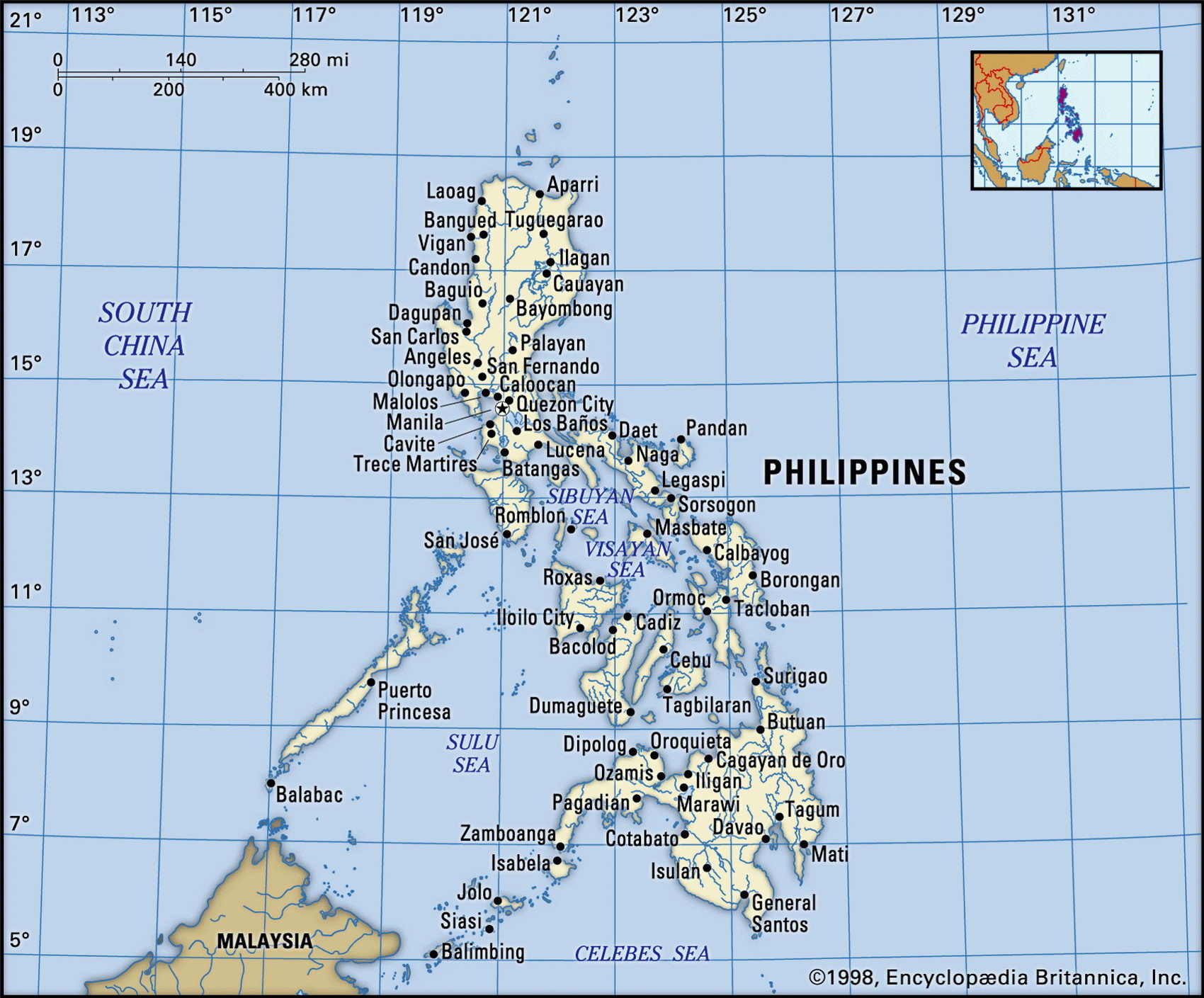
Map of Philippines and geographical facts
Where Philippines on the world map. Map of Philippines
Map of Philippines with cities. Where Philippines is on the world map. The main geographical facts about Philippines - population, country area, capital, official language, religions, industry and culture.

Philippines Fact File
Official name Republic of the Philippines
Form of government Republic with two legislative bodies (Senate and House of Representatives)
Capital Manila
Area 300,000 sq km (115,830 sq miles)
Time zone GMT +8 hours
Population 84,526,000
Projected population 2015 95,881,000
Population density 281.8 per sq km (729.7 per sq mile)
Life expectancy 68.1
Infant mortality (per 1,000) 27.9
Official languages Filipino (Tagalog)
Other languages English, more than 80 indigenous languages
Literacy rate 94.6%
Religions Roman Catholic 83%, Protestant 9 %, Muslim 5%, Buddhist and other 3%
Ethnic groups Malay 95.5 %, Chinese 1.5 %, other 3 %
Currency Philippine peso
Economy Services 48%, agriculture 42%, industry 10%
GNP per capita US$ 900
Climate Tropical, with wet season June to November
Highest point Mt Apo 2,954 m (9,692 ft)
Map reference Page 204
The Philippines present a combination that is unique in Asia. The people are Malayo-Poly-nesian; the majority of the population is Roman Catholic; English is the only common language in a country that has 87 native tongues; nearly four centuries of Spanish colonialism have left a flavor of Latin America; and 100 years of US influence
(following the Spanish-American War in 1898) mean that the Philippines is also somewhat Americanized.
Long ago, and before the Spaniard explorer Ferdinand Magellan arrived from across the Pacific on his round-the-world voyage in 1521, Islam had reached the southern island of Mindanao. It is still the religion of a substantial minority in that part of the country. The Spanish then imposed whatever unity the archipelago can be said to have (there are 7,107 islands), building haciendas and sugar plantations on its main islands. Administered by the USA from 1898, the Philippines was occupied by the Japanese during the Second World War, was governed by the corrupt Marcos regime from 1965 to 1986—when a widespread popular rebellion finally forced him into exile—and faced a wide range of insurgencies over more than 40 years. The first insurgents were communist; more recently they have often been members of the Islamic Moro Liberation Front.
There are three main island groupings within the archipelago: the Luzon group, the Visayan group, and the Mindanao and Sulu Islands. Luzon to the north and Mindanao to the south are the two biggest islands and together they constitute two-thirds of the country's total land area.
All the main islands have a rugged mountainous and volcanic topography with narrow coastal belts, a north-south alignment of upland ridges, and rivers that drain northwards. North of Manila Bay, and stretching to the shores of the Lingayan Gulf, is Luzon's heavily populated central plain. This is an important rice-producing area. Beyond hills to the northeast lies the fertile valley of the Cagayan River. Irrigated rice terraces, constructed by the Igorot people, rise up the mountain slopes of northern Luzon. The peninsulas of southeastern Luzon contain a number of volcanoes. The highest peak in the Philippines, Mt Apo (2,954 m, 9,693 ft), is on Mindanao.
Government investment and a range of tax concessions have been tried to encourage indus-
trial development. Mixing agriculture and light industry, the Philippine economy has been growing at a steady rate in recent years, without approaching the dynamic performance of other countries in the region.
While rice is the Philippines' main food crop, maize is the staple on the islands of Cebu, Leyte, and Negros, reflecting the country's old connection with Spanish America.
The country is well supplied with mineral resources and nickel, tin, copper, zinc and lead are processed in smelting and refining works. The Philippines is also the world's biggest supplier of refractory chrome, and the second biggest user of geothermal power after the USA. Foreign invest-ment turned sluggish as a consequence of the 1998 regional economic slowdown. Persistent weaknesses include rudimentary infrastructure, power failures due to inadequate generating capacity, low savings rates, and a foreign debt of US$ 45 billion.
Borobudur, the world's largest Buddhist monument, was built in the ninth century вс on the island of Java (left page, top). A coral reef in the Philippines (bottom left). The so-called "Chocolate Hills" in Bohol in the Philippines (top right).