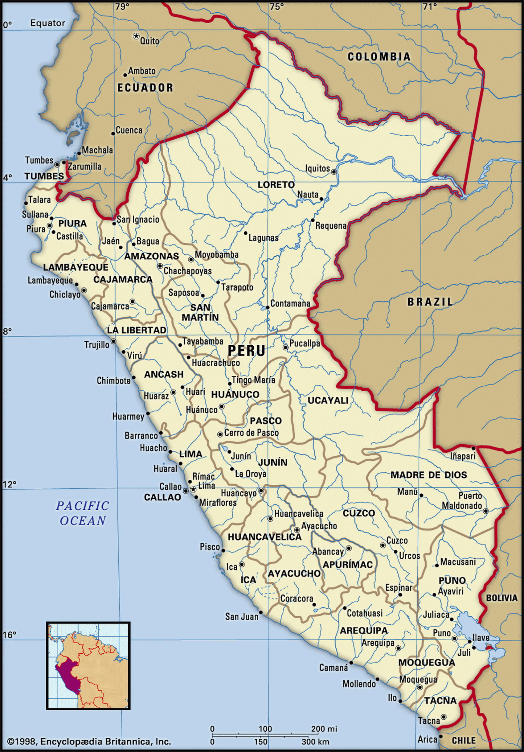
Map of Peru and geographical facts
Peru on the world map. Map of Peru with cities
Map of Peru with cities. Where Peru is on the world map. The main geographical facts about Peru - population, country area, capital, official language, religions, industry and culture.

Peru Fact File
Official name Republic of Peru
Form of government Republic with single legislative body (Congress)
Capital Lima
Area 1,285,220 sq km (496,223 sq miles)
Time zone GMT - 5 hours
Population 27,950,000
Projected population 2015 31,876,000
Population density 21.7 per sq km (56.3 per sq mile)
Life expectancy 70.4
Infant mortality (per 1,000) 41.4
Official languages Spanish, Quechua
Other language Aymara
Literacy rate 88.3%
Religions Roman Catholic 90%; others, including Anglican and Methodist 10%
Ethnic groups Indigenous 45 %, mixed indigenous-European 37%, European 15%; others (mainly African, Japanese, Chinese) 3%
Currency Nuevo sol
Economy Services 53 %, agriculture 35 %, industry 12 %
GNP per capita US$ 4,800
Climate Tropical in east, arid along coast, cold on high mountains
Highest point Nevado Huascaran 6,768 m (22,204 ft) Map reference Pages 450, 454-56
Humans have been living in Peru for about 10,000 years, and by 3,000 years ago Peruvian civilization had emerged, featuring irrigation agriculture, fine pottery, and expertly woven textiles of striking design. The Incas, one of the many tribes that inhabited the highlands of Peru, established a great empire in the thirteenth century that extended from Ecuador south to central Chile. Accomplished engineers, the Incas built an extensive network of roads and bridges, and many fine cities. The most famous of these is Machu Picchu, high above the Urubamba Valley. The Spanish came to Peru in 1532, lured by stories of a "kingdom of gold", and rapidly destroyed Inca civilization.
Recently Peru has experienced serious political trouble. Deep social divisions gave rise in 1980 to the movement known as Sendero Luminoso, or Shining Path, a Maoist guerrilla group. By 1990 its activities had resulted in the loss of 23,000 lives— most of them members of its own constituency, the Indians and mixed Spanish-Indians of the Andes— along with damage to the economy in the order of US$ 20 billion. In recent years the government has been able to bring about greater stability.
Some forty percent of Peru's population live on its arid coastal plain, which merges in the south with the rainless Atacama Desert of northern Chile. Numerous rivers crossing the plain from the Andes have made fertile valleys where cotton, rice, and sugarcane are grown. Inland, in the valleys of two high ranges of the Andean Sierra, the western and the eastern Cordilleras, about fifty percent of the people live, most of them Indians practicing subsistence agriculture. East of the Andes the land falls away into the almost uninhabited region of the Amazon Basin. Here, the Ucayali and Maranon Rivers flow through rainforest to Iquitos, the navigable port farthest inland on the Amazon River.
Peru's economy depends heavily on copper and petroleum exports. Agriculture is limited by the lack of arable land. Fishing for anchovies and sardines has been historically important in the cool Humboldt current offshore, but periodic warming of the ocean from the El Nino effect reduces the catch, as has occurred several times in recent years. In 1992 it fell by thirty percent.
The ruins of Machu Picchu are an incomparable spectacle for tourists, but poor facilities and guerrilla activities have discouraged visitors. Battered by hyperinflation, which reached 7,480 percent in 1990, Peru has recently undergone a series of economic reforms guided by the IMF and the World Bank. By 1995 inflation had been reduced to eleven percent, while growth in gross domestic product for that year was about seven percent, and in 2003 the inflation rate was 2.2 percent.