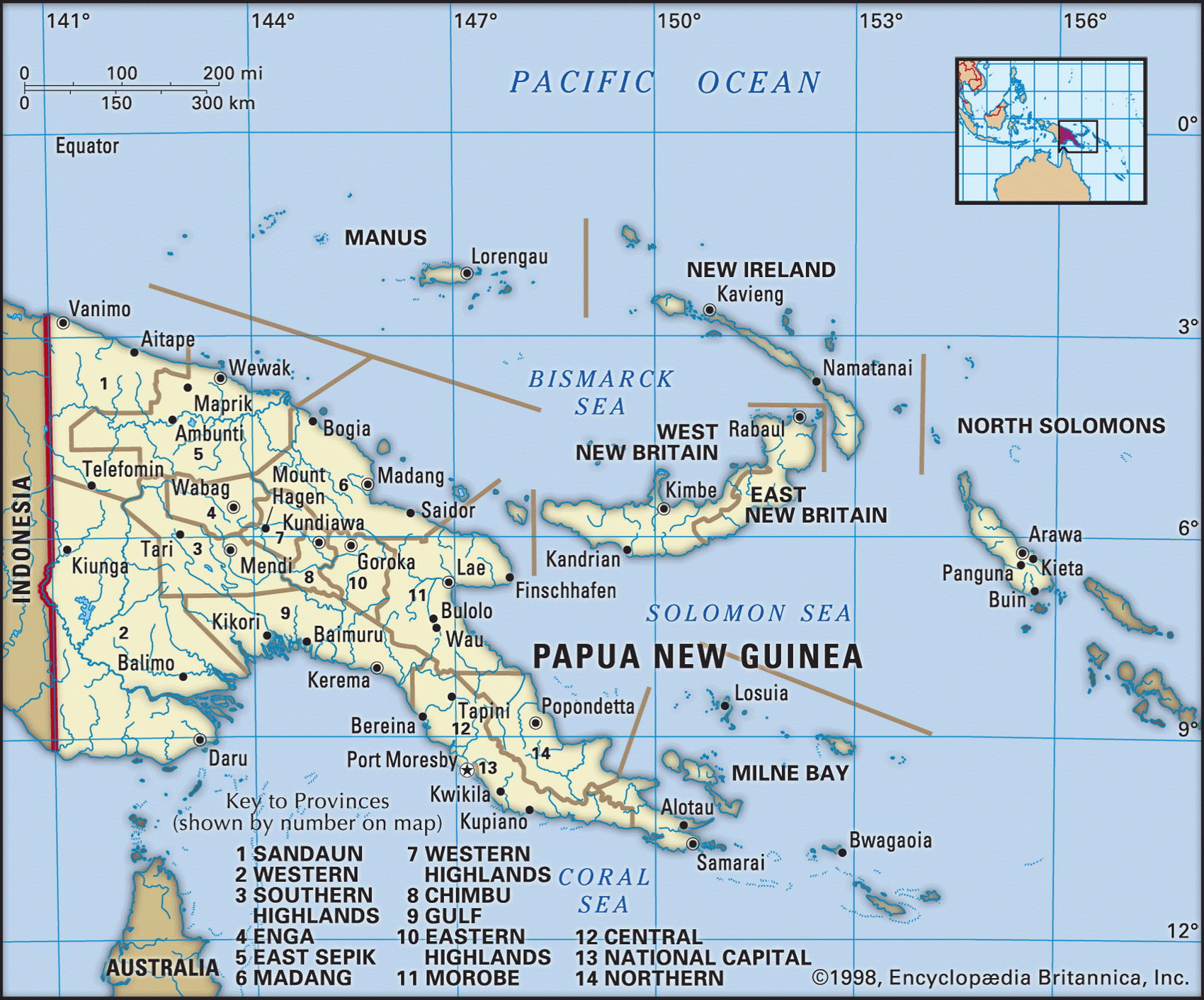
Map of Papua New Guinea and geographical facts
Where Papua New Guinea on the world map. Map of Papua New Guinea
Map of Papua New Guinea with cities. Where Papua New Guinea is on the world map. The main geographical facts about Papua New Guinea - population, country area, capital, official language, religions, industry and culture.

Fact File Papua New Guinea
Official name Independent State of Papua New Guinea
Form of government Constitutional monarchy with single legislative body (National Parliament or House of Assembly)
Capital Port Moresby
Area 461,690 sq km (178,258 sq miles)
Time zone GMT + 10 hours
Population 5,172,000
Projected population 2015 6,642,000
Population density 11.2 per sq km (29.0 per sq mile)
Life expectancy 63.8
Infant mortality (per 1,000) 56.5
Official languages English, Pidgin, Motu
Other languages Approximately 750 indigenous languages
Literacy rate 64.5 %
Religions Protestant 44% (including Lutheran 16%; Presbyterian, Methodist, London Missionary Society 8%; Anglican 5%; Evangelical Alliance 4%; other sects 11 %), indigenous beliefs 34%, Roman Catholic 22%
Ethnic groups New Guinea Papuan 84%; Polynesian, Chinese, European and other 16%
Currency Kina
Economy Agriculture 64%, services and industry 36%
GNP per capita US$ 2,400
Climate Tropical, with wet season December to March
Highest point Mt Wilhelm 4,509 m (14,793 ft) Map reference Page 140
Papua New Guinea consists of the eastern half of the large island of New Guinea, the 600 or so smaller islands of the Bismarck Archipelago, and the island Bougainville in the west. It lies north of northeastern Australia, just south of the equator. The largely rural population of "mainland" Papua New Guinea is made up of hundreds of distinct tribal
groups, speaking more than 750 different languages. They can be broadly divided into the lowlanders of the coast and the more isolated highlanders of the mountainous interior. The main island was named New Guinea in 1545 by a Spanish explorer who thought its people resembled those of the African Guinea coast. During the last two centuries the Netherlands, Germany, Japan, and Australia have controlled parts of it at different times. The western half—West Irian (Irian Jaya)—is now part of Indonesia; the eastern half, most recently administered by Australia, became fully independent as Papua New Guinea in 1975. Australia's relationship remains close, and it contributes twenty percent of the state budget.
A cordillera of rugged mountains runs down the main island. Covered with tropical forest, these mountains have an average elevation of between 2,500 m and 4,600 m (8,000 ft and 15,000 ft). In high and isolated valleys there are settlements where people live by cultivating traditional garden crops such as sweet potato, sugar cane, bananas, maize, and cassava. Pigs are raised, but are eaten mainly at ceremonies for status and ritual purposes. Taro is a staple food of the villagers in the lowlands, where yams and sago are also grown. Most of the soil is heavily leached, and fertile only in lowland areas and upland basins. On the southwestern coast the Fly River forms a vast swampy delta plain that is one of the world's biggest wetlands. The other major islands further east (New Ireland, New Britain, Manus, and Bougainville) are mainly of volcanic origin and are generally ringed by coral reefs. Nearly three-quarters of the land area of Papua New Guinea is covered with dense rainforest.
The country does have a variety of natural resources but rugged terrain and the high cost of infrastructure make their extraction difficult. Much travel and transport is only possible by air. While most people live by subsistence agriculture, copper and gold account for about sixty percent of export earnings. The main cash crops are coffee, cocoa, coconuts, palm kernels, tea, and rubber. Timber from the forests is also important. The government is looking to petroleum and mineral exports to drive its program of economic development, but there are social and political obstacles to be overcome. Corruption is endemic, tribal and criminal violence are high, and what was once the world's biggest copper mine— Panguna on Bougainville—has been closed for years. The Bougainville people are culturally kin to the people of the Solomons and strongly resent their domination by Papua New Guinea. Grievances over their share of the proceeds from the mine and compensation have become a demand for independence. After eruptions of violence in the 1990s, however, the government managed to consolidate the situation since 2001.
A Samoan church with a Mediterranean influence (left page). Mudmen at Mt Hagen, in the Papua New Guinea highlands (right).