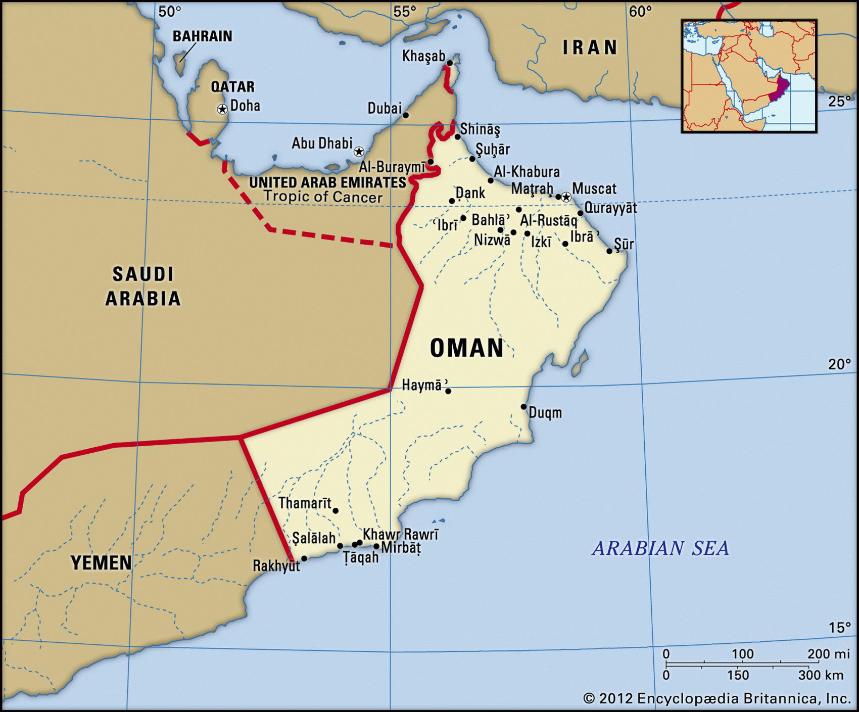
Map of Oman and geographical facts
Where Oman is on the world map
Map of Oman with cities. Where Oman is on the world map. The main geographical facts about Oman - population, country area, capital, official language, religions, industry and culture.

Oman Fact File
Official name Sultanate of Oman
Form of government Monarchy with advisory Consultative Council
Capital Masqat (Muscat)
Area 212,460 sq km (82,031 sq miles)
Time zone GMT + 4 hours
Population 2,714,000
Projected population 2015 4,110,000
Population density 12.8 per sq km (33.1 per sq mile)
Life expectancy 72.3
Infant mortality (per 1,000) 21.8
Official language Arabic
Other languages Baluchu, Farsi (Persian), Urdu, English
Literacy rate 80 %
Religions Ibadhi Muslim 75%, Sunni Muslim, Shi'a Muslim and Hindu 25%
Ethnic groups Mainly Arab with Baluchi, Indian, Pakistani, Sri Lankan, Bangladeshi, African minorities
Currency Omani rial
Economy Agriculture 50%, services 28%, industry 22%
GNP per capita US$ 8,200
Climate Mainly hot and arid; light rains in south June to September
Highest point Jabal Ash Sham 2,980 m (9,777 ft)
Map reference Pages 220-21
Oman is the third-largest country in the Arabian Peninsula. Situated on the peninsula's eastern corner, it looks across the Arabian Sea toward Baluchistan and India— in fact Baluchis form a small but significant part of the population. A small, separate, and highly strategic piece of Oman's territory is the tip of the Musandam Peninsula, commanding the entrance to the Strait of Hormuz. The Omani capital of Masqat (Muscat) was a trading center for hundreds of years, dhows sailing to India in one direction and down the African coast to Zanzibar in the other. Zanzibar itself was an Omani conquest, and in the 1960s, when it became part of Tanzania, many Arab Zanzibaris came to Oman. From 1798 Oman had strong ties with the British, and it became a British protectorate. Full independence came in 1971.
Sultan Qabus Ibn Sa'id rules his country as an absolute monarch, advised by a majlis ash shura ("consultative council"), but in the late 1990s the country was moving towards a constitutional government. In the late 1960s Oman faced a leftist rebellion in the western province of Dhofur, encouraged and supported by the People's Republic of Yemen across the border. This was defeated in 1975. Since then, with the country enjoying the prosperity of its oil and natural gas (huge additional reserves were discovered in 1991), peace has reigned.
In the north the limestone Hajar Mountains overlook the fertile coastal plain of al-Batinah. Most of Oman's population lives along the alluvial al-Batinah strip, where date gardens stretch for more than 250 km (155 miles). The Jabal Akhdar ridge is the highest part of the Hajar Range, rising to 3,107 m (10,193 ft). Soils in the upland region are poor: herders use the area for running camels, sheep, and goats. Wadis cutting the Jabal Akhdar ridge, underground canals, and wells provide a certain amount of irrigation. North of the ?ufar (Dhofar) uplands in the southwest the desert meets the sandy wastes of the Saudi Arabian Ar Rub' al Khali (or "Empty Quarter").
Rural Omanis live by subsistence agriculture, growing dates, limes, bananas, alfalfa, and vegetables. Pastoralists keep camels, cattle, sheep, and goats. The smaller urban population, however, including a considerable number of guest workers, depends on imported food. The national economy as a whole is dominated by the oil industry: petroleum accounts for nearly ninety percent of export earnings, about 75 percent of government revenues, and roughly forty percent of gross domestic product. Oman has proved oil reserves of 4 billion barrels, which are equal to twenty year's supply at the present rate of extraction.