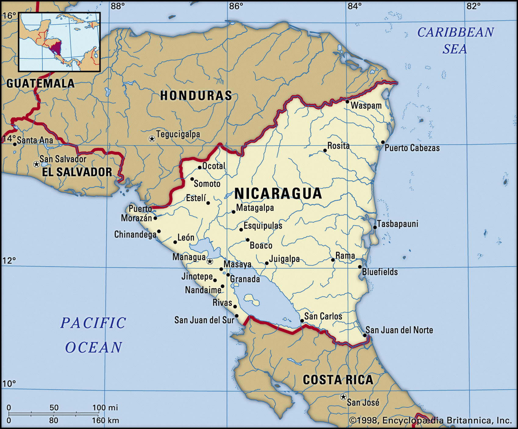
Map of Nicaragua and geographical facts
Nicaragua map with cities. Nicaragua on the world map
Map of Nicaragua with cities. Where Nicaragua is on the world map. The main geographical facts about Nicaragua - population, country area, capital, official language, religions, industry and culture.

Nicaragua Fact File
Official name Republic of Nicaragua
Form of government Republic with single legislative body (National Assembly)
Capital Managua
Area 129,494 sq km (49,998 sq miles)
Time zone GMT-6 hours
Population 5,024,000
Projected population 2015 7,216,000
Population density 38.8 per sq km (100.5 per sq mile)
Life expectancy 69.4
Infant mortality (per 1,000) 32.5
Official language Spanish
Other languages Indigenous languages (among them Chibcha, Miskito, Sumo), English
Literacy rate 68.2%
Religions Roman Catholic 95 %, Protestant 5 %
Ethnic groups Mixed indigenous-European 69%, European 17%, African 9%, indigenous 5%
Currency Cordoba
Economy Agriculture 47%, services 37%, industry 16%
GNP per capita US$2,500
Climate Tropical in lowlands, cooler in highlands; wet season May to January
Highest point Pico Mogoton 2,107 m (6,913 ft)
Map reference Page 428
The largest republic in the Central American isthmus, Nicaragua is also the least populated. The western half, including Lake Nicaragua, the largest lake in Central America, was settled by the Spanish in the sixteenth century, and the Caribbean shore was for two centuries the British protectorate of Mosquito Coast (Costa de Miskitos). Becoming independent from Spain in 1821, Nicaragua then experienced much instability. The 45-year right-wing rule of the Somoza family ended in 1979 when they were overthrown by the Marxist Sandinistas. Their left-wing rule provoked a US-backed insurgency known as the "contras." In free elections held in 1996 a right-of-center party defeated the Sandinistas. President Arnoldo Aleman was excluded from the elections in 2001 because of claims of curruption. In 2002 he was convicted.
Nicaragua's broad plain on the Caribbean side leads to a coastal region of lagoons, beaches, and river deltas. Rainfall here is heavy and the tropical wildlife includes crocodile and jaguar. Inland, toward the east, there are mountain ranges broken by basins and fertile valleys. In the west and south a broad depression containing Lakes Managua and Nicaragua runs from the Gulf of Fonseca, on the Pacific coast, to the mouth of the San Juan del Norte River, on the Caribbean. Before the Panama Canal was built this was an important route across the isthmus. This is a region of cotton growing. Overlooking the lakes are forty volcanoes, among them the active Momotombo. An earthquake destroyed most of Managua in 1972.
Nicaragua is still reorganizing its economy— at one point under the Sandinistas inflation reached 3,000 percent. Large-scale confiscation of estates took place under the Sandinistas but the peasants to whom land was given have not always been able to live off their allotments, and some land has been resold. Coffee and cotton are the major export crops. Staples grown by the many subsistence farmers include maize, rice, and beans. Mineral production is led by silver and gold followed by tungsten, lead, and zinc. Falling prices for most of Nicaragua's export commodities, the loss of aid, and the impact of IMF policies reduced the nation's income in 1993 to close to Haiti's— the poorest in the Americas. There is a huge foreign debt. Conditions peculiar to Nicaragua include Sandinista "land reforms" in which luxury properties were seized and given to the movement's leaders and "privatized" state operations that are union-controlled. More than fifty percent of agricultural and industrial firms are state-owned.