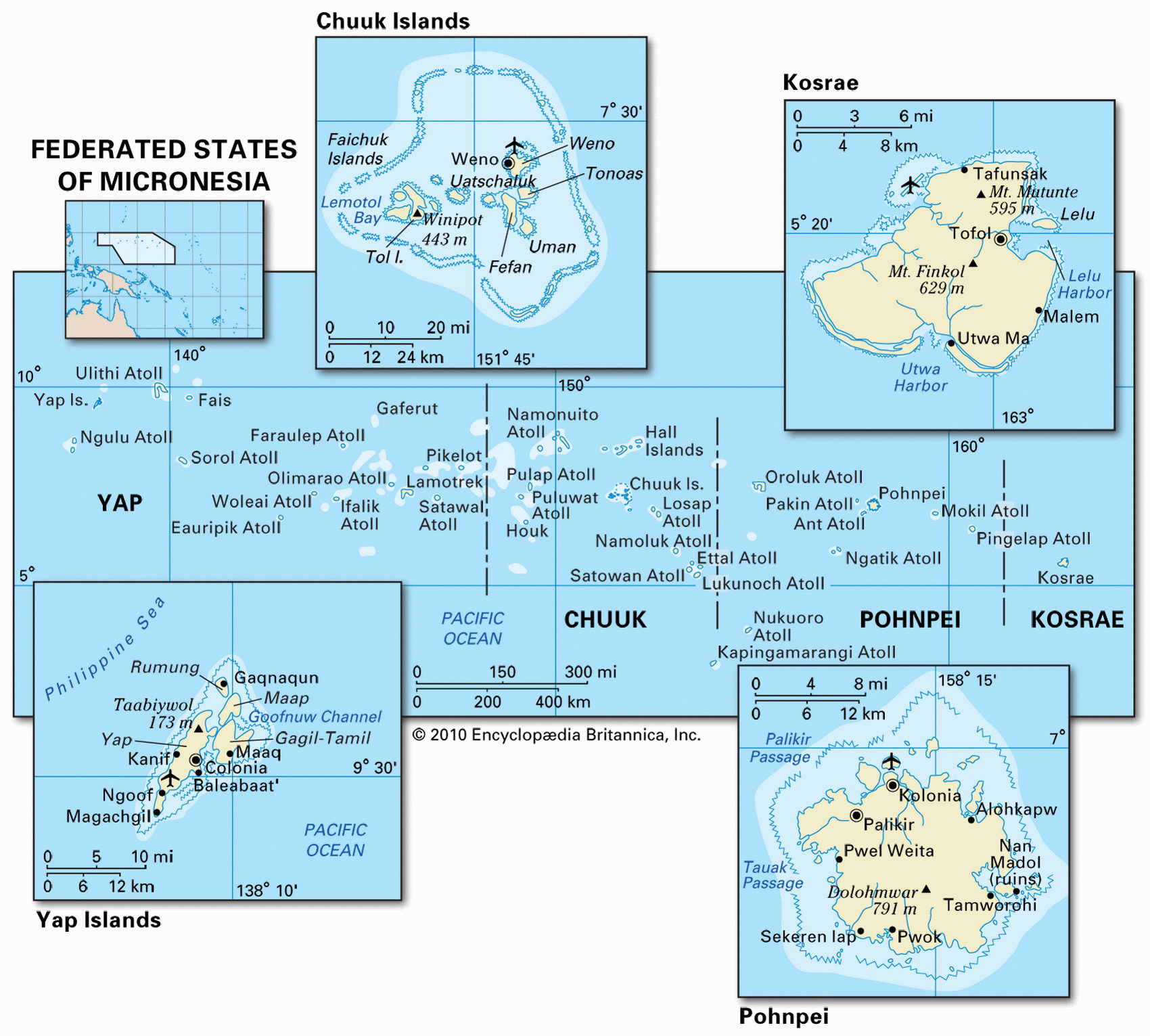
Map of Micronesia and geographical facts
Where Micronesia on the world map. Map of Micronesia
Map of Micronesia with cities. Where Micronesia is on the world map. The main geographical facts about Micronesia - population, country area, capital, official language, religions, industry and culture.

Fact File Micronesia
Official name Federated States of Micronesia
Form of government Federal Republic in free association with the USA; single legislative body (Congress)
Capital Palikir
Area 702 sq km (271 sq miles)
Time zone GMT + 9-10 hours
Population 136,000
Projected population 2015 172,000
Population density 193.7 per sq km (501.8 per sq mile)
Life expectancy 68.5
Infant mortality (per 1,000) 34.0
Official language English
Other languages Micronesian and Polynesian languages
Literacy rate 89 %
Religions Roman Catholic 50%, Protestant 47%, other and none 3 %
Ethnic groups Micronesian and Polynesian Currency US dollar
Economy Agriculture, fishing, services, textiles
GNP per capita US$ 2,000
Climate Tropical. Heavy rainfall year-round and occasional typhoons
Highest point Totolom 791 m (2,595 ft)
Map reference Page 138
The Federated States of Micronesia consist of four states—Yap, Chuuk (Truk), Pohnpei, and Kosrae—made up of four island groups spread out across 3,200 km (2,000 miles) of ocean. Formerly known as the Caroline Islands, they are located in the northern Pacific about halfway between Australia and Japan. They are populated by Micronesian and Polynesian peoples divided into nine separate ethnic groups.
First settled around 1000 вс, the islands were visited by Spanish seafarers in 1565 and were annexed by Spain in 1874. In 1899 Spain sold them to Germany, and at the beginning of the First World War Japan took posession of them. After Japan's defeat in the Second World War, the USA took over the administration of the islands. US control ended in 1986 when the Federated States of Micronesia and the USA signed a fifteen-year Compact of Free Association that is currently renegotiated. This granted internal self-government, with the USA retaining responsibility for the country's defense.
During the course of the Second World War Chuuk was one of Japan's most important bases in the Pacific Ocean. Tourists now come to the island to scuba dive among the numerous wartime wrecks in the lagoon.
The 607 widely scattered islands of Micronesia vary geologically from high and mountainous terrain to low coral atolls. Most of the islands are volcanic in origin, and the hot, rainy climate produces lush vegetation and tropical rainforest. Volcanic outcrops occur on Pohnpei, Kosrae, and Chuuk. Some of the atolls lack any surface water. Droughts occur frequently on Chuuk, often leading to water rationing. In 1992 emergency supplies of water had to be brought from Guam to Chuuk by the US Navy.
Subsistence fishing and farming occupies the majority of the population, with farmers growing tropical fruits and vegetables, coconuts, cassava (tapioca), sweet potatoes, and black pepper, and raising pigs and chickens. Fish, bananas, and black pepper are exported, and as a result of attempts at economic diversification a clothing industry has been developed.
Aside from deposits of high-grade phosphate the islands have few mineral resources. Imports exceed exports by a ratio of more than four to one, and the country as a whole depends heavily on financial aid from the USA. There is some potential for tourism—with their rich marine life the islands are a prime destination for scuba divers—but poor infrastructure and the country's remoteness hinder further development.