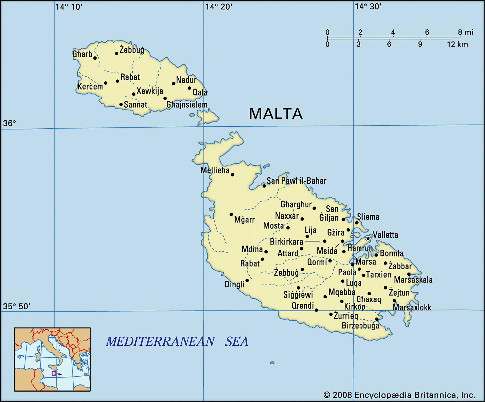
Map of Malta and geographical facts
Malta on the world map. Map of Malta
Map of Malta with cities. Where Malta is on the world map. The main geographical facts about Malta - population, country area, capital, official language, religions, industry and culture.

Malta Fact File
Official name Republic of Malta
Capital Valletta
Area 320 sq km (124 sq miles)
Time zone GMT + 1 hour
Population 398,000
Form of government Republic with single legislative body (House of Representatives)
Projected population 2015 411,000
Population density 1,243.8 per sq km (3,209.7 per sq mile)
Life expectancy 78.3
Infant mortality (per 1,000) 5.7
Official languages Maltese, English
Literacy rate 88.8%
Religions Roman Catholic 98 %, other 2 %
Ethnic groups Mixed Arab, Sicilian, French, Spanish, Italian and English
Currency Maltese lira
Economy Government 37%, services 26%, manufacturing 22%, teaching programs 9%, construction 4%, agriculture 2%
GNP per capita US$ 17,000
Climate Temperate, with mild, wet winters and hot, dry summers
Highest point Dingli Cliffs 245 m (804 ft) Map reference Pages 361, 362
The Republic of Malta consists of an archipelago of three inhabited islands—Malta, Gozo, and Comino—and three tiny uninhabited islands, which are little more than rocky outcrops. They are situated in the center of the Mediterranean Sea 93 km (58 miles) south of Sicily. Malta is the largest and most populous of the islands. It contains the capital, Valletta, the country's fifth largest city, picturesquely situated on a promontory between two harbors, and the four larger cities of Birkirkara, Qormi, Hamrun, and Sliema. Successive civilizations have recognized the importance of Malta's position and the advantages of its many harbors. It was occupied successively by the Phoenicians, the Greeks, and the Romans. In the ninth century ad, when it was part of the Byzantine Empire, it was conquered by Arabs but fell two centuries later to Sicily and then in 1282 to Spain. In 1530 the Spanish king gave Malta to the Knights of St John, a religious order, which built and fortified the town of Valletta and occupied the island of Malta until it was seized by Napoleon in 1798. Britain took the island in 1800 and held it until 1947, when the country was granted self-government as a parliamentary democracy. In 1964 Malta gained full independence. In 1987 Malta created a new constitution that declared its political neutrality, a feature not affected by its entry into the EU in 2004.
The three inhabited islands are mostly flat— although the island of Malta is undulating in places—with spectacular rocky coastlines. There is little natural vegetation and there are no forests or major rivers. Low rainfall, poor drainage, a limestone base and a hot climate all contribute to the paucity of the islands' shallow soils, which, however, support a range of cereal and vegetable crops as well as substantial vineyards.
Apart from limestone for building, Malta has virtually no mineral resources and is heavily dependent on imported materials. It has no natural sources of energy and produces only one-fifth of its population's food needs. Tourism is the mainstay of the economy. Every year about a million visitors, mainly from the United Kingdom, arrive to enjoy its beaches, its historic towns, and its rugged scenery. Ship repairs and clothing and textile manufacture are other significant industries. The average income is low by Western standards and Maltese residents are among the least affluent of Western Europeans.