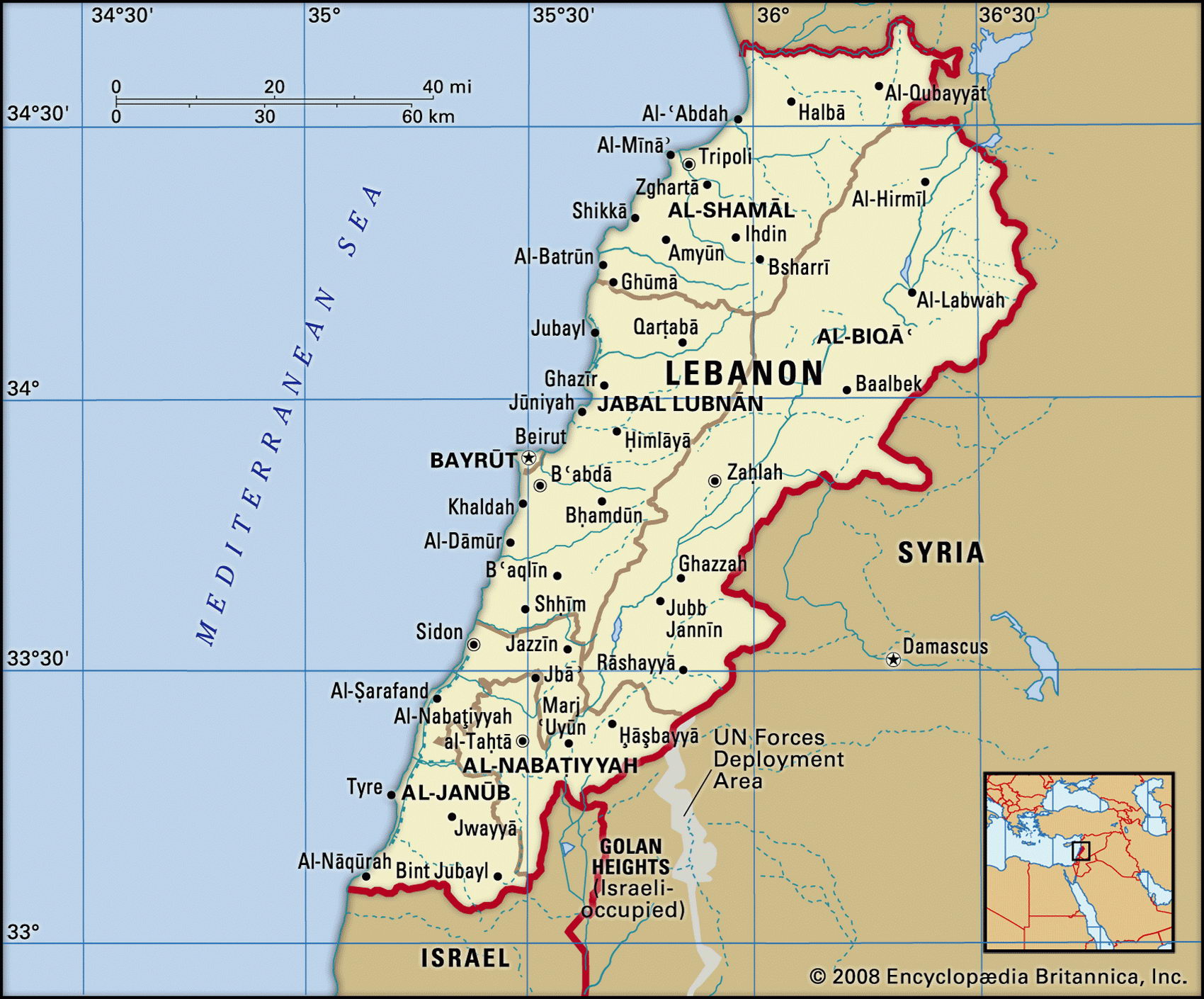
Map of Lebanon and geographical facts
Where Lebanon is on the world map
Map of Lebanon with cities. Where Lebanon is on the world map. The main geographical facts about Lebanon - population, country area, capital, official language, religions, industry and culture.

Lebanon Fact File
Official name Republic of Lebanon
Form of government Republic with single legislative body (National Assembly)
Capital Beirut
Area 10,400 sq km (4,015 sq miles)
Time zone GMT + 2 hours
Population 3,678,000
Projected population 2015 4,219,000
Population density 353.7 per sq km (916.1 per sq mile)
Life expectancy 71.8
Infant mortality (per 1,000) 27.4
Official languages Arabic
Other languages Armenian, Kurdish, French, English
Literacy rate 86.4 %
Religions Muslim 70%, Christian 30%
Ethnic groups Arab 95%, Armenian 4%, other 1 %
Currency Lebanese pound
Economy Services 60%, industry 28%, agriculture 12%
GNP per capita US$ 5,200
Climate Temperate, with short mild, wet winters and long, hot, dry summers. In winter rainfall in mountains often turns to snow
Highest point Qurnat as Sawda' 3,088 m (10,131 ft)
Map reference Page 225
Lebanon, a small country on the eastern shore of the Mediterranean Sea, consists of the region that was once known as the Levant. It has a history that goes back at least 5,000 years. First settled by the Phoenicians around 3000 вс, it saw Alexander the Great (356-323 вс) conquer the Phoenician city of Tyre, and it later became part of the Roman Empire. Early in the seventh century ad Maronite Christians (named after Maro, a Syrian monk who was the sect's founder) settled in northern Lebanon; later, Druze Arabs, who are aligned with Shi'ite Islam, settled in the south of the country, and Sunni Muslims came to the coastal towns. From the eleventh to the thirteenth century the region was a center of confrontation between Western Christians and Muslims during the Crusades. It then became part of the Muslim Mameluke Empire. In 1516 the Ottoman Turks took control of the country, their rule finally ending with conquest by the British and French during the First World War.
From 1920, following the withdrawal of Turkish forces, a French administration sought to balance the interests of the country's various religious groups. During this period Beirut, which already had a cosmopolitan air, took on a distinctly French flavor. The city became both a center of international commerce and a playground of the rich. The country gained independence in 1946. Deep and persistent tensions between Muslim and various non-Muslim sections of the population led to an outbreak of guerrilla war in 1975. For the next fifteen years much of the country was devasted by civil war, and much of its urban infrastructure was destroyed.
From the narrow coastal plain along the Mediterranean, where crops are grown with the aid of irrigation, the land rises eastward to form the Lebanon Mountains (Jabal Lubnan). Running from north to south, these cover about thirty percent of Lebanon's land area. Between the harsh slopes of this range and the Anti-Lebanon Chain (Jabal ash Sharqi) that borders Syria lies the fertile el Beqaa Valley which is another agricultural area. This is traversed by the River Litani on its journey south, before emptying into the Mediterranean Sea above §ur (the ancient city of Tyre).
Decades of fighting have left the Lebanese economy in ruins and there is a severe housing shortage. Tourism, which was once an important source of revenue, is beginning to revive with the rebuilding of the once-popular Corniche seafront area at Beirut. Since the decline of industry as a result of the war, agriculture has come to play a more important role: crops include apples, citrus fruits, bananas, carrots, grapes, tomatoes, and olives. Opium poppies and cannabis are illegally produced for export. Traditional areas of activity in the past were banking, food processing, textiles, cement, oil refining, and chemicals. The country now depends heavily on foreign aid.