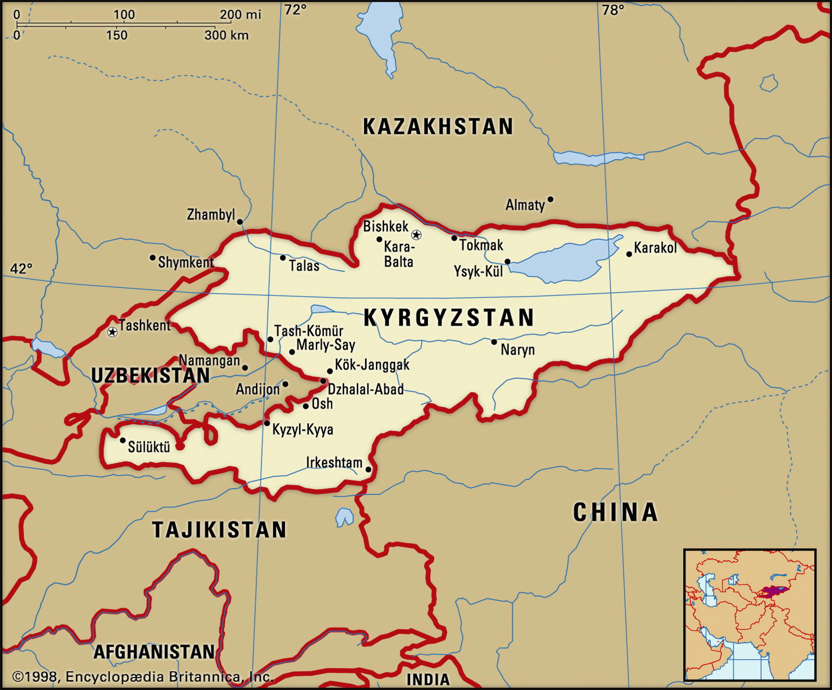
Map of Kyrgyzstan and geographical facts
Kyrgyzstan on the world map. Map of Kyrgyzstan
Map of Kyrgyzstan with cities. Where Kyrgyzstan is on the world map. The main geographical facts about Kyrgyzstan - population, country area, capital, official language, religions, industry and culture.

Kyrgysztan Fact File
Official name Kyrgyz Republic
Form of government Republic with two legislative bodies (Assembly of People's Representatives and Legislative Assembly)
Capital Bishkek
Area 198,500 sq km (76,641 sq miles)
Time zone GMT + 6 hours
Population 4,823,000
Projected population 2015 5,836,000
Population density 24.3 per sq km (62.9 per sq mile)
Life expectancy 63.6
Infant mortality (per 1,000) 75.9
Official language Kyrghiz
Other language Russian
Literacy rate 97%
Religions Sunni Muslim 70%, Christian (predominantly Russian Orthodox) 30%
Ethnic groups Kyrghiz 52.5 %, Russian 21.5 %, Uzbek 13%, Ukrainian 2.5%, German 2.5%, other 8 %
Currency Som
Economy Services 41 %, agriculture 38%, industry 21 %
GNP per capita US$ 2,800
Climate Subtropical in southwest, temperate in valleys, cold and snowy in mountains
Highest point Pik Pobedy 7,439 m (24,406 ft)
Map reference Page 223
Kyrgyzstan is a small, mountainous, landlocked country in Central Asia. China lies over the massive peaks of the Tian Shan Range along its southeast border, Kazakhstan is to the north, and Uzbekistan and Tajikistan are to the southwest. Not only is Kyrgyzstan the least urbanized of all the ex-Soviet republics, its population is growing faster in rural areas than in the towns. Native Kyrgyz are barely a majority and ethnic tension with Uzbeks and other nationals from nearby countries is a feature of everyday life. Fierce clashes between Kyrgyz and Uzbeks took place in the border city of Osh in 1990. Historically, the once nomadic Muslim Kyrgyz pastoralists are descended from refugees of Mongolian and Turkic origin who entered the region in the thirteenth century, escaping from Mongol invaders. For a while in the eighteenth century the region came under Manchu domination, then during the nineteenth century Russia began to colonize the country. Russian immigrants took the best land, settling in the low-lying, fertile areas. For years after the country's incorporation into the Soviet Union in the 1920s, resistance was carried out by local guerrilla groups called basmachi. Since independence in 1991, Kyrgyzstan has pursued liberal political and economic policies.
Geographically, Kyrgyzstan is dominated by the western end of the Tian Shan Range, which rises to Pik Pobedy (7,439 m; 24,406 ft) on the Chinese border. A large part of this mountain range is permanently snow-capped. The rest of the country is made up of a series of mountainous parallel ridges, separated by deep valleys and basins. The deep waters of Lake Ysyk-K6l are surrounded by snowy mountains in the northeast. The Fergana Valley, which is the main lowland region, lies in the southwest.
Much of the lower land is pasture for sheep, pigs, cattle, goats, horses, and yaks. Irrigated land is used to produce crops ranging from sugar beet and vegetables to rice, cotton, tobacco, grapes, and mulberry trees (for feeding silkworms). There are major salination problems caused mainly by the excessive irrigation of cotton.
Cotton, wool, and meat are the main agricultural products and exports: one of Kyrgyzstan's strengths is agricultural self-sufficiency. It has small quantities of coal, oil, gas, and the extensive snow-covered ranges ensure great hydropower potential. Energy policy aims at developing these resources in order to make the country less dependent on Russia. After the introduction of market reforms, and a program to control inflation, attention has turned to stimulating growth. This will not be easy: the economy is still dominated by the state and by the mentality of collective farming. Foreign aid plays a major role in the country's budget.