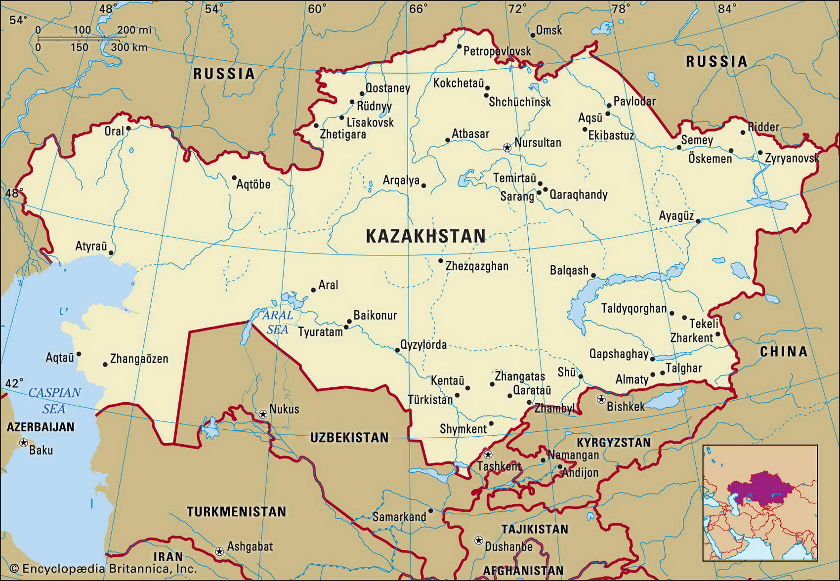
Map of Kazakhstan and geographical facts
Kazakhstan on the world map. Map of Kazakhstan
Map of Kazakhstan with cities. Where Kazakhstan is on the world map. The main geographical facts about Kazakhstan - population, country area, capital, official language, religions, industry and culture.

Kazakhstan Fact File
Official name Republic of Kazakhstan
Form of government Republic with two legislative bodies (Senate and Majilis)
Capital Aqmola (Astana)
Area 2,71 7,300 sq km (1,049,150 sq miles)
Time zone GMT + 6 hours
Population 16,742,000
Projected population 2015 15,957,000
Population density 6.2 per sq km (16 per sq mile)
Life expectancy 63.4
Infant mortality (per 1,000) 59
Official language Kazakh
Other language Russian
Literacy rate 98.4%
Religions Muslim 47%, Russian Orthodox 44%, Protestant 2%, other 7%
Ethnic groups Kazak 41.9%, Russian 37%, Ukrainian 5.2%, German 4.7%, Uzbek 2.1 %, Tatar 2%, other 7.1 %
Currency Tenge
Economy Services 43%, industry 31 %, agriculture 26%
GNP per capita US$ 5,900
Climate Mainly arid; cold winters and hot summers; cooler in north
Highest point Khan Tangiri Shyngy 6,995 m (22,949 ft)
Map reference Pages 222
With a land area nearly as large as India, Kazakhstan is an important member of the newly formed Commonwealth of Independent States (CIS). In earlier times, when it was a Soviet Republic, authorities used the region for testing nuclear weapons and for exiling ethnic minorities.
In the 1950s and 1960s when the Soviet "virgin lands" project was underway, vast tracts of pasture were sown with wheat or given over to livestock production, and waters from rivers running into the Aral Sea were used in irrigation schemes. As a result, the sea shrank by seventy percent.
During the years of Soviet domination, high levels of immigration from Russia resulted in the Kazakhs being outnumbered. Outmigration of Russians since 1991 and the return of many expatriates has resulted in a Kazak majority once more, but ethnic tensions remain high.
Much of the country is tablelands—the eroded tableland of the east featuring shallow uplands, depressions, and lakes—and there are also several mountains ranges in the east including the Altai Range (Mongol Altayn Nuruu). Running from north to south, steppe country gives way to desert or semidesert, though irrigation schemes have made large areas productive between the Aral Sea and Lake Balkhash (Balqash Koli).
With a climate marked by intense winter cold and extreme summer heat, rainfall is generally low. The lakes in the center of the country are saline, as are the marshes in the west, and in the central region there are few permanent rivers. The grassy steppes of the north are the most naturally fertile part of the country. Though the region has traditionally been associated with livestock rearing (Kazakhstan still supports up to 200,000 nomadic shepherds and herdsmen) the agricultural policies of the Soviet period converted much pasture to grain cultivation. By 1989 the country accounted for twenty percent of the entire cultivated area of the Soviet Union and twelve percent of its grain output.
Other crops grown include fruits, potatoes, vegetables, sugar beet, and cotton. High quality wool is produced, and Kazakhstan supplies meat to surrounding countries. Industry is based mainly on processing raw materials: fuel, metals, textiles, chemicals, and food. Products include rolled metals, agricultural machinery, plastics, clothing, footwear, paper, and cement. Well endowed with oil and gas reserves, the country also has deposits of coal, iron ore, bauxite, copper, nickel, tungsten, zinc, and silver. In addition, it holds seventy percent of CIS gold reserves. The government has been pursuing a moderate program of reform and privatization— investment incentives have been established, state controls have been lifted, and assets privatized. But government control of key industries remains extensive. Lack of pipeline transportation for oil export hinders a likely source of economic growth.
Environmental problems are extensive and severe. Radioactive or toxic chemical sites associated with weapons development are widespread. The drying up of the Aral Sea has left a crust of chemical pesticides which is periodically blown about in noxious dust storms.