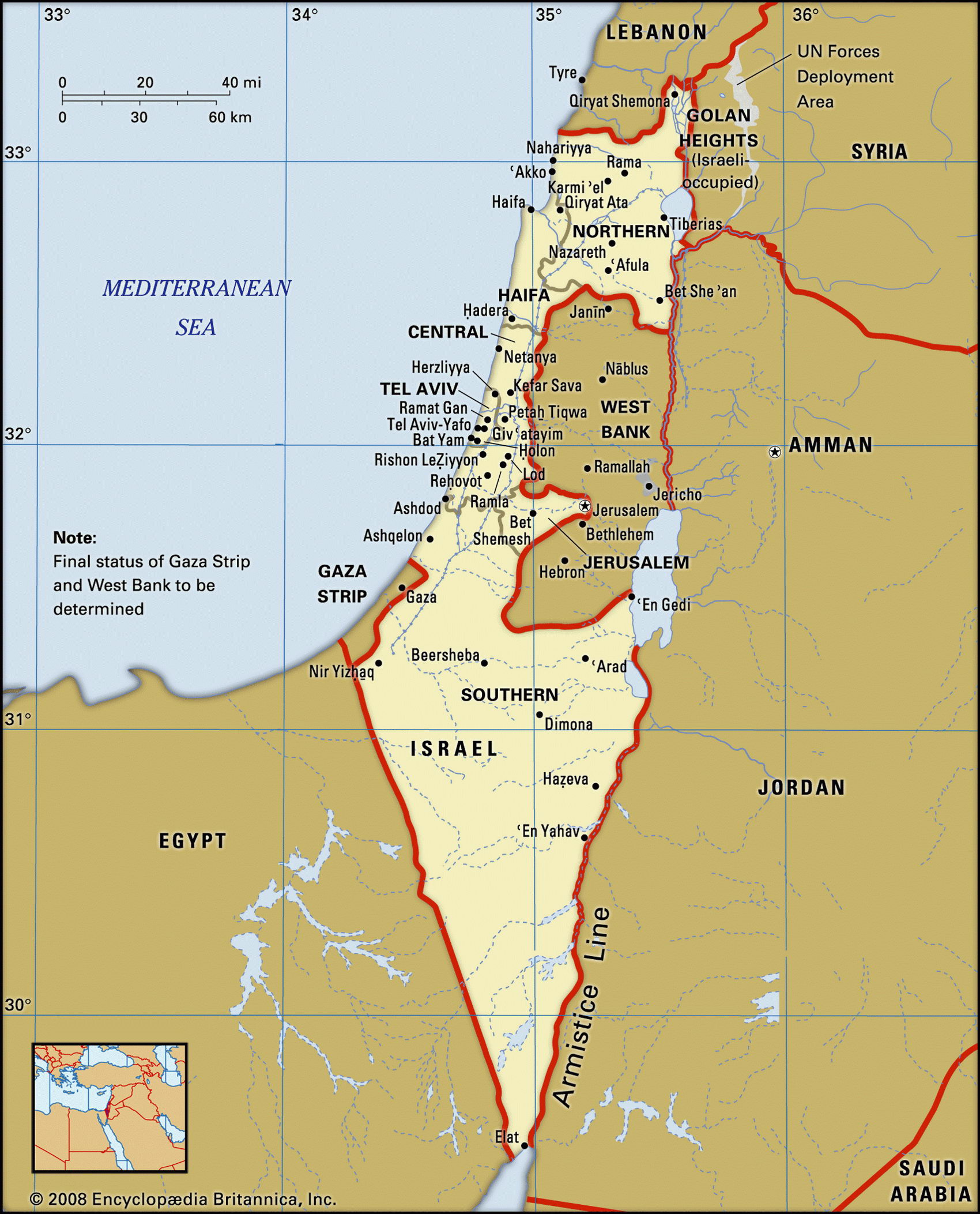
Map of Israel and geographical facts
Where Israel is on the world map
Map of Israel with cities. Where Israel is on the world map. The main geographical facts about Israel - population, country area, capital, official language, religions, industry and culture.

Israel Fact File
Official name State of Israel
Form of government Republic with single legislative body (Knesset)
Capital Jerusalem
Area 20,770 sq km (8,019 sq miles)
Time zone GMT + 2 hours
Population 6,030,000
Projected population 2015 7,714,000
Population density 290.3 per sq km (752.0 per sq mile)
Life expectancy 78.9
Infant mortality (per 1,000) 7.6
Official languages Hebrew, Arabic
Other languages Yiddish, English, French, German, Hungarian, Romanian, Russian, Spanish
Literacy rate 95 %
Religions Jewish 82%, Muslim 14%, Druze 2%, Christian 2%
Ethnic groups Jewish 82 %, Arab 17 %, other 1 %
Currency Shekel
Economy Services 75%, industry 21 %, agriculture 4%
GNP per capita US$ 19,000
Climate Temperate along coast, hot and dry in south and east
Highest point Har Meron 1,208 m (3,963 ft) Map reference Page 225
Created as a Jewish homeland in 1948, Israel is a small country with an illustrious past that involves three of the world's great religions, and an uncertain future. For fifty years, through a succession of wars with hostile Arab neighbors, a secular, democratic political system has managed to constrain strong religious tendencies deeply rooted in the past. Key events in the Jewish history of the region are: first, the occupation of the land by the twelve tribes of Israelites 4,000 years ago; second, the scattering (or "diaspora") of the one surviving tribe, the Jews, following a failed revolt against Rome in ad 138; third, the rise of Zionism in the nineteenth century advocating a Jewish homeland in Palestine as a solution to centuries of exile and persecution; fourth, the Holocaust, which reinforced arguments for territorial independence; and fifth, the proclamation of the State of Israel in May 1948, leading to the emigration of many Palestinian Arabs. Since then there has been continual strife between the new state and its neighbors. Israel's subsequent seizure and occupation of additional territories (see entries for Gaza Strip and West Bank) has been bitterly resisted by their Arab inhabitants. This conflict has intensified as Jewish religious fundamentalists continue to expand their settlements in contested areas. After the country signed a peace treaty with Egypt in 1979 and especially while Prime Minister Yitzhak Rabin conducted a policy of appeasement with Jordan and the Palestinians until he was murdered in 1995 by a Jewish extremist, the peace process made quite some progress and the foundation of an independent Palestinian state is also the declared goal of the international community. However, ongoing acts of terrorism by Arab fanatics as well as the very harsh politic of the State of Israel in its pursuit of domestic security continue to pose a severe threat to the peace process.
Geographically, Israel consists of four main regions: the Mediterranean coastal plain of Sharon, irrigated by the Qishon, Soreq, and Sarida Rivers; the rolling hills extending from Galilee in the north to Judea in the center; the Jordan-Red Sea section of the Rift Valley running north to south the full length of the eastern frontier from the Golan Heights to the Gulf of Aqaba; and the great southern wedge of desert plateau called the Negev
(Ha Negev), which makes up about half of Israel's total land area. With irrigation, the Mediterranean coastal plain is fertile fruitgrowing country. In the drier southern stretches its dunes have been stabilized with grass and tamarisk and reclaimed for pasture. The northern hill country around Galilee has good rainfall and a rich black soil weathered from basalt. Here and around Judea, pine and eucalyptus trees have been planted to anchor the soil and retain water. The Valley of Jezreel ('Emeq Yizre'el), lying between Galilee and Samaria to the south, has deep alluvial soils which are intensively tilled for market gardening. The Jordan-Western Negev Scheme—the most ambitious of Israel's various irrigation projects— diverts water from the upper Jordan and other sources through a series of culverts and canals south to the Negev. The desert is widely covered with blown sand and loess, but tomatoes and grapes grow well when supplied with water.
Israel has the most industrialized economy in the region. Iron is smelted at Haifa and there are steel foundries at Acre. Chemical manufacturing takes place at Haifa and in plants by the Dead Sea. A national electricity grid provides power to widely dispersed towns where factories produce textiles, ceramics, and other products. In the Negev south of Beersheba new settlements mine oil, copper, and phosphates, the factories using potash and salt from the Dead Sea. Israel is largely self-sufficient in food production except for grains. Diamonds, high-technology equipment, and agricultural products are leading exports. About half the government's external debt is owed to the USA, its main source of aid. To earn foreign exchange the government has been targeting high-tech international market niches such as medical scanning equipment. Matters of continuing economic concern include the high level of unemployment following large-scale immigration from the former USSR, and the need to import strategically important raw materials.
A spice seller in a Bahrain market (left page top). The Old City of Yerushalayim (Jerusalem) from the Mount of Olives, with the golden dome of the al Aqsa Mosque (below).