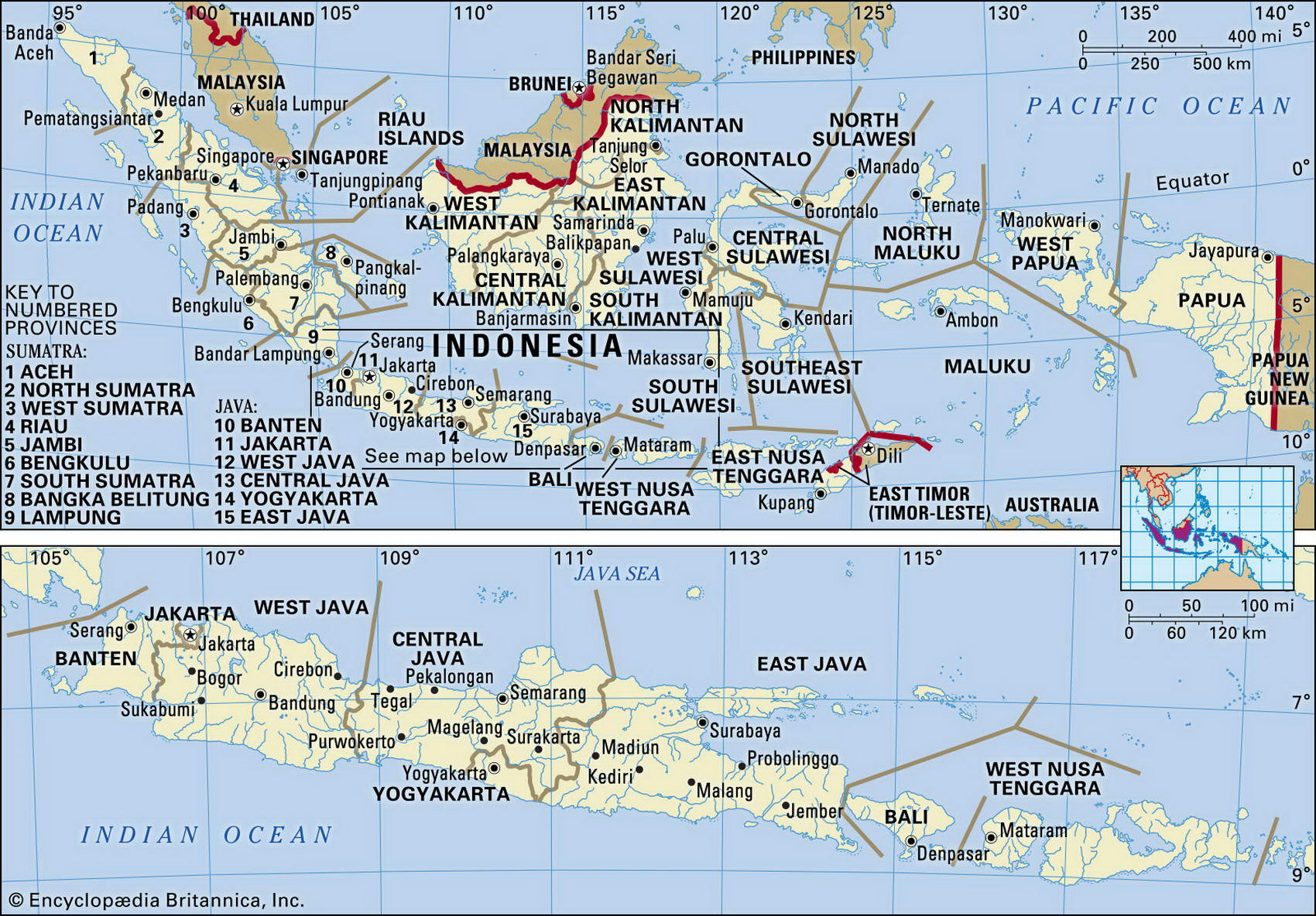
Map of Indonesia and geographical facts
Where Indonesia on the world map. Map of Indonesia
Map of Indonesia with cities. Where Indonesia is on the world map. The main geographical facts about Indonesia - population, country area, capital, official language, religions, industry and culture.

Indonesia Fact File
Official name Republic of Indonesia
Form of government Republic with single legislative body (House of Representatives)
Capital Jakarta
Area 1,919,440 sq km (741,096 sq miles)
Time zone GMT +7-9 hours
Population 231,328,000
Projected population 2015 250,068,000
Population density 120.5 per sq km (312.1 per sq mile)
Life expectancy 68.3
Infant mortality (per 1,000) 39.4
Official language Bahasa Indonesia
Other languages English, Dutch, indigenous languages
Literacy rate 83.8%
Religions Muslim 88%, Protestant 6%, Roman Catholic 2%, Hindu 2%, Buddhist 1 %, other 1%
Ethnic groups Javanese 45%, Sundanese 14%, Madurese 7.5%, coastal Malays 7.5%, other 26%
Currency Rupiah
Economy Agriculture 54%, services 38%, industry 8%
GNP per capita US$ 3,000
Climate Tropical, with wet season December to March (except in Moluccas where wet season is June to September)
Highest point Puncak Jaya 5,030 m (16,502 ft) Map reference Pages 198-99, 200-01
After 30 years of economic progress, the collapse of the economy in 1998 triggered an outbreak of violent protest against the government. A change of leadership followed in 1999, and promises of new and more open elections. Nevertheless, long-suppressed class, ethnic, and religious conflicts have been unleashed. Guerrilla groups have fought for a long time against the national unity imposed on the numerous Indonesian islands by Jakarta's urban elite. Islamic fundamentalism also seems to have gained ground since 11 September 2001.
The 13,677 islands of the world's largest archipelago (6,000 of them inhabited) rest on the platform of two continental shelves. The southern chain of islands, from Sumatra to Timor, including Borneo, form part of the Sunda shelf, a largely submerged extension of the Asian continent. The northern Moluccas and New Guinea rest on the Sahul shelf, a northern extension of the Australian continent. Between the shelves, Sulawesi and the southern Moluccas form the island summits of suboceanic mountain ranges flanked by sea trenches 4,500 m (14,800 ft) deep. All Indonesia's main islands are mountainous: Sumatra, Java, and the Lesser Sunda Islands (Nusa Tengara) form an arc containing 200 volcanoes, many of which are active—Krakatoa (Pulau Rakata) among them.
In Sumatra, along with 10 active volcanoes there are a number of crater lakes, such as Lake Toba, at an altitude of 900 m (2,953 ft). Much of the island was once forested but over-cutting of timber in the lowlands means that native forest is now restricted to reserves and national parks. Isolated mountain forests remain in remote areas. The heavily populated island of Java has a long range containing 50 active volcanoes and 17 that are only recently dormant.
Throughout the archipelago many coasts are lined with mangrove swamps, notably in eastern Sumatra and southern Kalimantan. Several of the islands are of great beauty: tourism, not only to Bali, has been a major activity in recent years.
Indonesia's complex and varied population, and its four major religions—Islam, Hinduism, Christianity, and Buddhism—reflect the country's varied history. Hinduism was the first major religious influence 2,000 years ago, followed by Buddhism in the seventh century ad. Hindu-Buddhist religious authority began to decline with the collapse of the Majapahit Empire in the fourteenth century, and the arrival of Arab traders from the west gradually established Islam as the dominant religion.
Under Dutch colonial Rile from 1608, the islands were from 1830 subject to a severe regime known as the Culture System. This involved the forced cultivation of commercial crops for export and resulted in a distortion of the traditional economy. Indonesia fell to the Japanese in the Second World War. After 1945 Indonesia became independent.
About 18 percent of Indonesia's land area is permanently cultivated. Most people live by agriculture, growing rice, maize, cassava, and sweet potato. There are also extensive plantations producing rubber, palm oil, sugarcane, coffee, and tea. The last 30 years have seen an intensive state-directed drive toward industrialization, based on abundant natural resources: oil, natural gas, timber, metals, and coal. Prosperity was initially tied to oil exports, but now the economy's growth depends on the continuing expansion of non-oil exports.