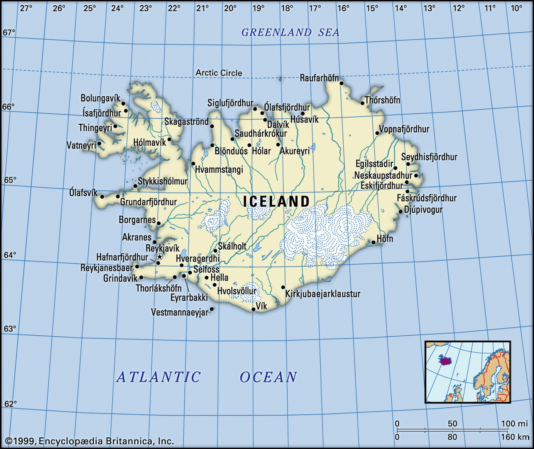
Map of Iceland and geographical facts
Iceland on the world map. Map of Iceland
Map of Iceland with cities. Where Iceland is on the world map. The main geographical facts about Iceland - population, country area, capital, official language, religions, industry and culture.

Iceland Fact File
Official name Republic of Iceland
Form of government Republic with single legislative body (Parliament)
Capital Reykjavik
Area 103,000 sq km (39,768 sq miles)
Time zone GMT
Population 280,000
Projected population 2015 305,000
Population density 2.7 per sq km (6.9 per sq mile)
Life expectancy 79.7
Infant mortality (per 1,000) 3.5
Official language Icelandic
Literacy rate 99.9%
Religions Lutheran 96%; other Protestant and Roman Catholic 3 %; none 1 %
Ethnic groups Icelandic 97%; others including Danish, American, British, Norwegian, German 3 %
Currency Krona
Economy Services 61 %, industry 35%, agriculture 4%
GNP per capita US$27,100
Climate Cool temperate, with cool, windy winters and mild, wet summers
Highest point Hvannadalshnukur 2,119 m (6,952 ft)
Map reference Page 284
True to its name, one-tenth of the total area of the island of Iceland, in the north Atlantic Ocean, is covered in icefields and glaciers. The human occupation of this island, which lies just south of the Arctic Circle, dates back to the late ninth century ad when Norwegian Vikings settled there. In the thirteenth century the Icelanders submitted to Norwegian rule and a century and a half later, when the Norwegian and Danish monarchies were combined, they came under Danish control. In 1918 Iceland was granted its independence, but still owed allegiance to the Danish monarch. In 1944, as the result of a referendum, Iceland chose to become a republic.
In 1972, because of its economic dependence on the surrounding seas, Iceland, without consultation with other nations, more than quadrupled the extent of its territorial waters from twelve to fifty nautical miles. Three years later it extended them to 200 nautical miles, a provocative move that brought condemnation, particularly from Britain, and gave rise to serious aggression at sea between Icelandic and British fishing vessels. After long and tense negotiations Britain was later granted some degree of access to the disputed waters.
In addition to icefields and glaciers, Iceland's spectacularly rugged and volcanic landscape includes hot springs, sulphur beds, geysers, lava fields, deep rocky canyons, and plummeting waterfalls. There are numerous small freshwater lakes and 200 volcanoes, many of which are active. Earth tremors, and occasionally larger quakes, are a frequent feature.
The interior of the island consists mainly of an elevated plateau of basalt, interspersed with occasional high peaks. There are small areas of forest and very little arable land. In the north, however, there are extensive grasslands where a small number of sheep, cattle, and horses can graze. More than ninety percent of the population lives in towns and cities around the coast, mainly in the southwest corner near Reykjavik.
Deep-sea fishing is the backbone of Iceland's economy, with fish and associated products constituting more than two-thirds of the country's exports. Apart from fish processing, aluminum smelting from imported bauxite and cement manufacture are growing industries. All of Iceland's domestic and industrial electricity needs are met by locally generated power from hydroelectric or geothermal plants. About one in four Icelanders is employed in manufacturing and processing industries. Iceland attracts about 150,000 tourists a year, more than half its permanent population, making tourism an important income-earner.
The people of Iceland enjoy a very high standard of living. Their economy is robust but is susceptible to variations in international fish prices. The country's free healthcare system has contributed to a life expectancy that is among the highest in the world.