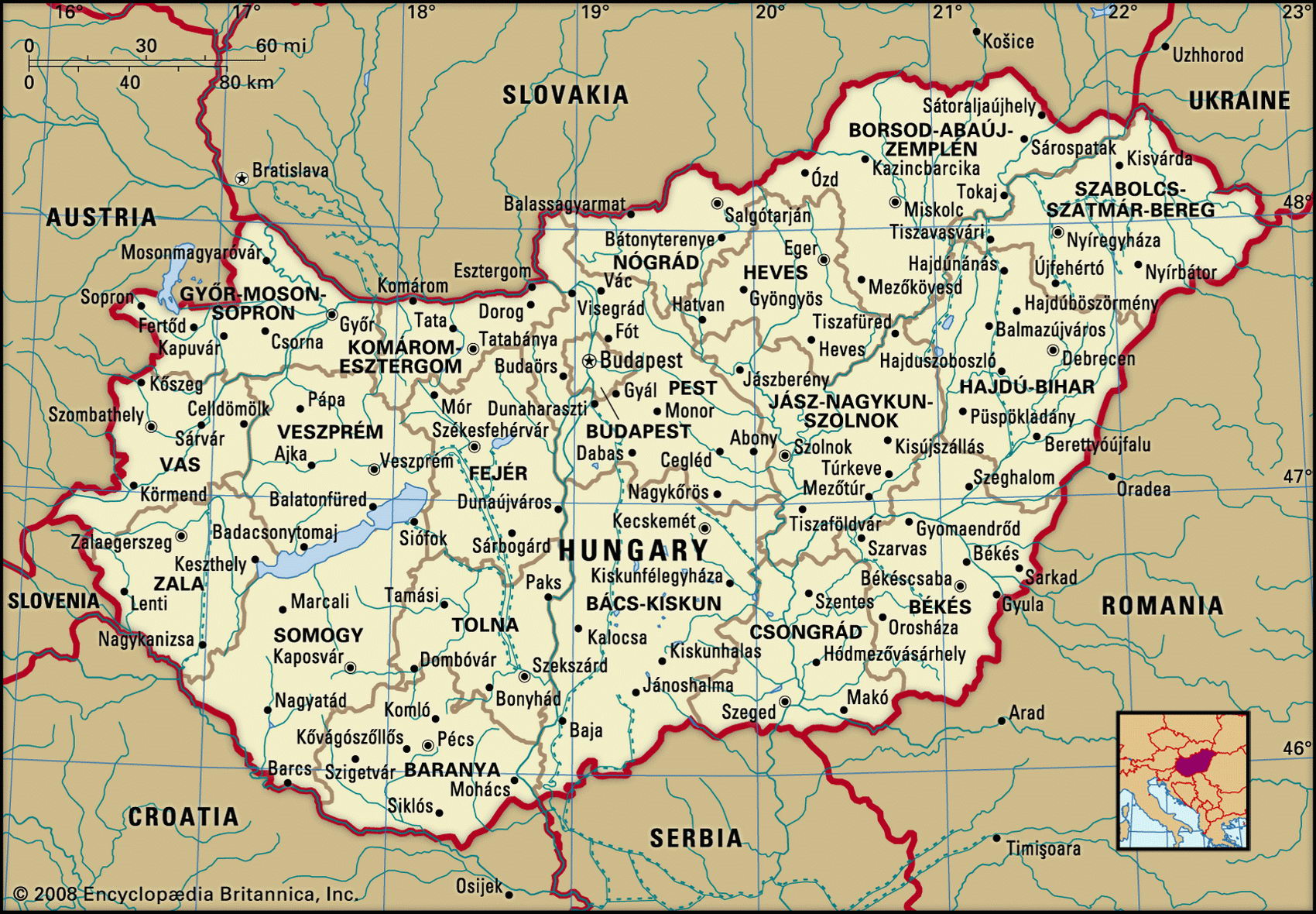
Map of Hungary and geographical facts
Hungary on the world map. Map of Hungary
Map of Hungary with cities. Where Hungary is on the world map. The main geographical facts about Hungary - population, country area, capital, official language, religions, industry and culture.

Fact File Hungary
Official name Republic of Hungary
Form of government Republic with single legislative body (National Assembly)
Capital Budapest
Area 93,030 sq km (35,919 sq miles)
Time zone GMT + 1 hour
Population 10,075,000
Projected population 2015 9,254,000
Population density 108.3 per sq km (280.5 per sq mile)
Life expectancy 71.9
Infant mortality (per 1,000) 8.8
Official language Hungarian
Other language Romany, German, Croatian, Slovakian, Romanian
Literacy rate 99 %
Religions Roman Catholic 67.5%, Calvinist 20%, Lutheran 5%, other 7.5%
Ethnic groups Hungarian 89.9%, Gypsy 4%, German 2.6%, Serb 2%, Slovak 0.8%, Romanian 0.7%
Currency Forint
Economy Services 59%, industry 33%, agriculture 8 %
GNP per capita US$ 13,300
Climate Temperate; cold, wet winters and warm summers
Highest point Mt Kekes 1,014 m (3,327 ft) Map reference Pages 289, 294, 296
Alandlocked Central European country, Hungary shares borders with Serbia and Montenegro to the south, Croatia and Slovenia to the southwest, Austria to the west, Slovakia to the north, Ukraine to the northeast and Romania to the southeast. Modern Hungary had its beginnings in the eighth century ad, when the area was settled by the Magyars, nomadic tribes from the central Volga. Their kingdom thrived and expanded. In the sixteenth century the Turks seized the central part of Hungary and the northern and
western sections of the country accepted Austrian Habsburg rule rather than submit to Turkish domination. In 1699 the Turks were driven out and the entire country came under Habsburg rule. Continuing unrest and the defeat of Austria by the Prussians in 1866 culminated in the establishment of Austria-Hungary as a dual monarchy in 1867. The defeat of Austria-Hungary in 1918 was followed by the establishment of the Hungarian nation, but with two-thirds of its former territory and almost 60 percent of its former population ceded to surrounding states. In the Second World War Hungary sided with Germany against the Soviet Union and was finally occupied by Soviet forces as they pushed southward in 1945. In 1948 communists again seized control with Soviet support, beginning 42 years of Soviet domination. A popular anti-communist uprising in 1956 was brutally suppressed by the Soviet Union. As the Soviet Union began to collapse a new constitution in 1989 set the scene for Hungary's first multi-party elections in 1990.
Hungary is drained by two southward-flowing rivers, the Danube and the Tisza. These two rivers traverse the Great Hungarian Plain, which occupies most of the eastern part of the country and more than half the total land area. West of the Danube a line of hills and mountains runs northeast from Lake Balaton, which covers an area of 370 sq km (140 sq miles), to the Slovakian border, where it joins the Carpathian Mountains. Northwest of these hills the Little Hungarian Plain extends to the westward-flowing Danube, which
here separates Hungary from Slovakia. While most of the low-lying areas have long been cleared of trees, some of the forested areas still survive in the hills and mountains.
Most of the two plains areas are fertile agricultural country, although there are dry sandy expanses, as well as marshlands that are home to a rich variety of waterbirds. More than seventy percent of Hungary's agricultural land is devoted to crops, the most important of which are maize, wheat, sugar beet, and sunflowers. Of the rest, more than four-fifths are meadows and pasturelands and the rest are orchards and vineyards. Pigs and poultry are the most extensively farmed livestock.
Except for natural gas, bauxite, and lignite—a low quality coal that provides much of the country's energy—Hungary is poorly endowed with mineral resources. It imports most of the raw materials for its now largely privatized industries, among which iron and steel production and the manufacture of fertilizers, pharmaceuticals, and cement are prominent. Most of these industries are located in the north and are centered mainly around the capital, Budapest, and Miskolc, which is the second-largest city and is situated in the far northeast. Aluminum, using local bauxite, is manufactured north of Lake Balaton.
Hungarians enjoy a reasonable standard of living by the standards of former communist countries, though it still compares unfavorably with that in most Western countries. Pollution of air, soil, and water is a major problem and almost half the population lives in seriously affected areas.