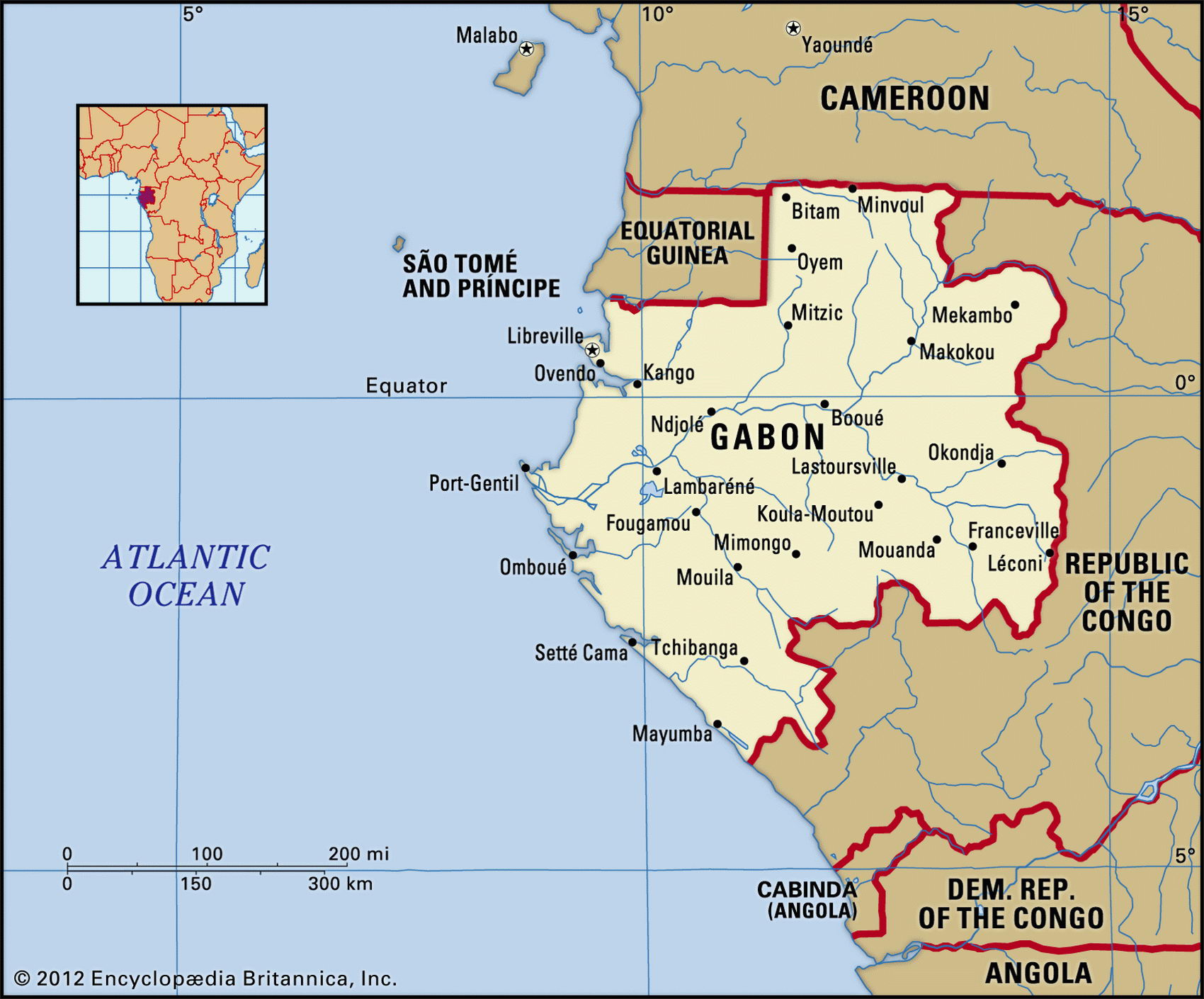
Map of Gabon and geographical facts
Gabon on the world map. Map of Gabon
Map of Gabon with cities. Where Gabon is on the world map. The main geographical facts about Gabon - population, country area, capital, official language, religions, industry and culture.

Gabon Fact File
Official name Gabonese Republic
Form of government Republic with single legislative body (National Assembly)
Capital Libreville
Area 267,670 sq km (103,347 sq miles)
Time zone GMT + 1 hour
Population 1,234,000
Projected population 2015 1,757,000
Population density 4.6 per sq km (11.9 per sq mile)
Life expectancy 49.1
Infant mortality (per 1,000) 93.5
Official language French
Other languages Indigenous languages (including Fang, Myene, Bateke, Bapounou/ Eschira, Bandjabi)
Literacy rate 63.2%
Religions Christian 55%-75%, Muslim less than 1 %, indigenous beliefs 3%
Ethnic groups Mainly Bantu tribes (including Fang, Eshira, Bapounou, Bateke) 92%, foreign Africans and Europeans 8%
Currency CFA (Communaute Financiere Africaine) franc
Economy Agriculture 65%, industry and commerce 30%, services 5%
GNP per capita US$ 5,500
Climate Tropical, with dry season mid-May to mid-September
Highest point Mt Iboundji 1,575 m (5,167 ft) Map reference Page 368
Aslave station for the Portuguese after their arrival in 1483, Gabon was administered by France from 1842. After the French navy suppressed the still-continuing local slave trade, it released captives at a place on the coast which it named Libreville (Libertyville). Since Gabon achieved independence in 1966 France has
continued to play a role in the country's politics and in its relatively prosperous oil-based economy.
The original inhabitants of this heavily forested equatorial country were probably Pygmies; today the main tribal group is the Fang. However, the thirty-year rule of President El Hadj Omar Bongo (a Bateke who converted to Islam under Libyan influence in 1973) depended on a coalition that was designed to exclude the Fang from power. Widespread dissatisfaction with this state of affairs led to the introduction of a multi-party system in 1991. Whether this has allowed other ethnic groups a real voice in Gabonese politics is not yet clear. However, the country has in the meantime developed into an island of stability in the region and since 1994 there have not been any complaints concerning human rights questions.
Geographically, a coastal plain marked by sandbars and lagoons is interrupted by the estuary of the Ogooue River. The wooded basin of this large watercourse dominates Gabon, sixty percent of the country's land area being drained by its tributaries. These flow down from the African central plateau and the borders of Equatorial Guinea and Cameroon to the north, and from Congo to the east and south.
Before the development of oil and manganese in the early 1970s, valuable timbers were one of the country's main exports. These included Gabon mahogany, ebony, and walnut. Even today as much as two-thirds of Gabon's total land area consists of untouched rainforest, but the completion in 1986 of the Trans-Gabon Railway from the port of Owendo to the interior town of Massoukou is likely to lead to further exploitation of timber resources.
Gabon has considerable mineral resources. It has about one-quarter of the world's known reserves of manganese, and is the world's fourth biggest manganese producer. France imports most of its uranium from Gabon. Oil currently accounts for fifty percent of gross domestic product. This figure, when combined with Gabon's small population, gives a distorted picture of the country's per capita earnings, disguising the fact that more than half the country's people still make their living by subsistence farming. A wide gap separates rural people from the urban elite and the country faces economic problems.