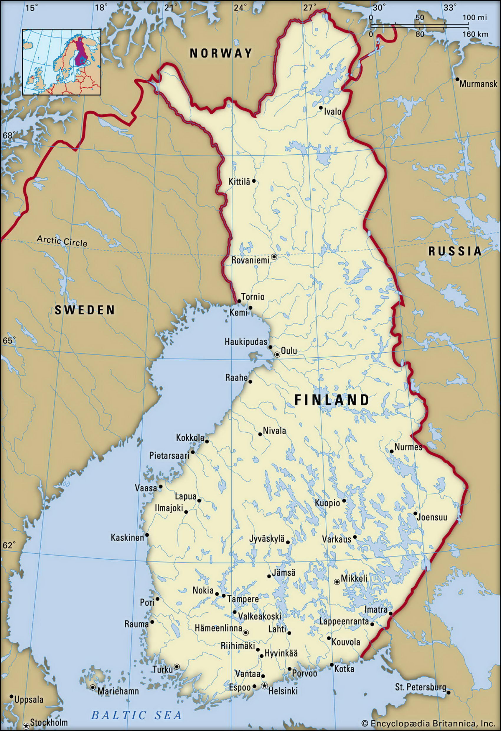
Map of Finland and geographical facts
Finland on the world map. Map of Finland
Map of Finland with cities. Where Finland is on the world map. The main geographical facts about Finland - population, country area, capital, official language, religions, industry and culture.

Finland Fact File
Official name Republic of Finland
Form of government Republic with single legislative body (Parliament)
Capital Helsinki
Area 338,145 sq km (1 30,558 sq miles)
Time zone GMT + 2 hours
Population 5,184,000
Projected population 2015 5,180,000
Population density 15.3 per sq km (39.7 per sq mile)
Life expectancy 77.8
Infant mortality (per 1,000) 3.8
Official languages Finnish, Swedish
Other languages Russian, Lapp
Literacy rate 100 %
Religions Lutheran 89%, Greek Orthodox 1 %, none 9 %, other 1 %
Ethnic groups Finnish 93.6%, Swedish 6.2%, others (including Lapp, Gypsy, Tatar) 0.2%
Currency Euro
Economy Services 60%, industry 34%, agriculture 6%
GNP per capita US$ 26,200
Climate Mainly cold temperate, but polar in arctic regions
Highest point Haltiatunturi 1,328 m (4,357 ft) Map reference Pages 284-85, 287
Except for a small section of Norway which cuts it off from the Arctic Ocean, Finland is the most northerly country in continental Europe. As well as its northern boundary with Norway, Finland borders northern Sweden to the west and the Russian Federation in the east. In the south, the Gulf of Finland, the easternmost part of the Baltic Sea, separates it from Estonia, and on the west the Gulf of Bothnia, a northern inlet of the Baltic, sits between it and southern Sweden.
Modern Finland has its roots in a seventh century ad invasion by tribes from the Volga. They displaced the Lapps, Asiatic people who had lived in the area for centuries, and drove them north. Only about 2,500 Lapps, or Sami, who have their own culture and language, now survive in the north, tending reindeer herds. Viking incursions followed and in the twelfth century Swedes invaded Finland, bringing Christianity. Finland remained under Swedish control for the next 650 years, until 1809, when the Russians took over. Swedish influence is still evident in the country's significant Swedish-speaking minority, and the fact that some towns have both Finnish and Swedish names. A relatively benign Russian rule allowed considerable freedoms and encouraged a resurgence of the Finnish language, which had largely fallen into disuse. A more oppressive regime towards the end of the century fanned Finnish nationalism, and at the time of the Russian Revolution in 1917 the country seized its independence.
Finland's harsh climate and the ruggedness of its northern regions means that most of its people live in the more moderate south. Much of the land consists of flat expanses of granite rock, the legacy of extensive glaciation. Remnants of an ancient mountain range, rising in places to more than 1,000 m (3,300 ft), exist in Lapland, the northern part of the country. There are more than 60,000 substantial lakes throughout Finland, mainly in the south, and tens of thousands of smaller ones. Forests, mainly of pine, birch, and spruce cover more than half the land area, contributing to the country's heavy reliance on timber-related industries, including wood processing, pulp, and papermaking.
Less than one-tenth of Finland's land is arable and agricultural production, which includes cereals, potatoes and sugar beet, is confined to the summer months, when the country is not snowbound.
In the 1980s living standards in Finland rose markedly, rivaling those of Sweden, although they fell back in the recession of the early 1990s. The country has an effective government-sponsored health system and the population is one of the most literate and highly educated in the world.