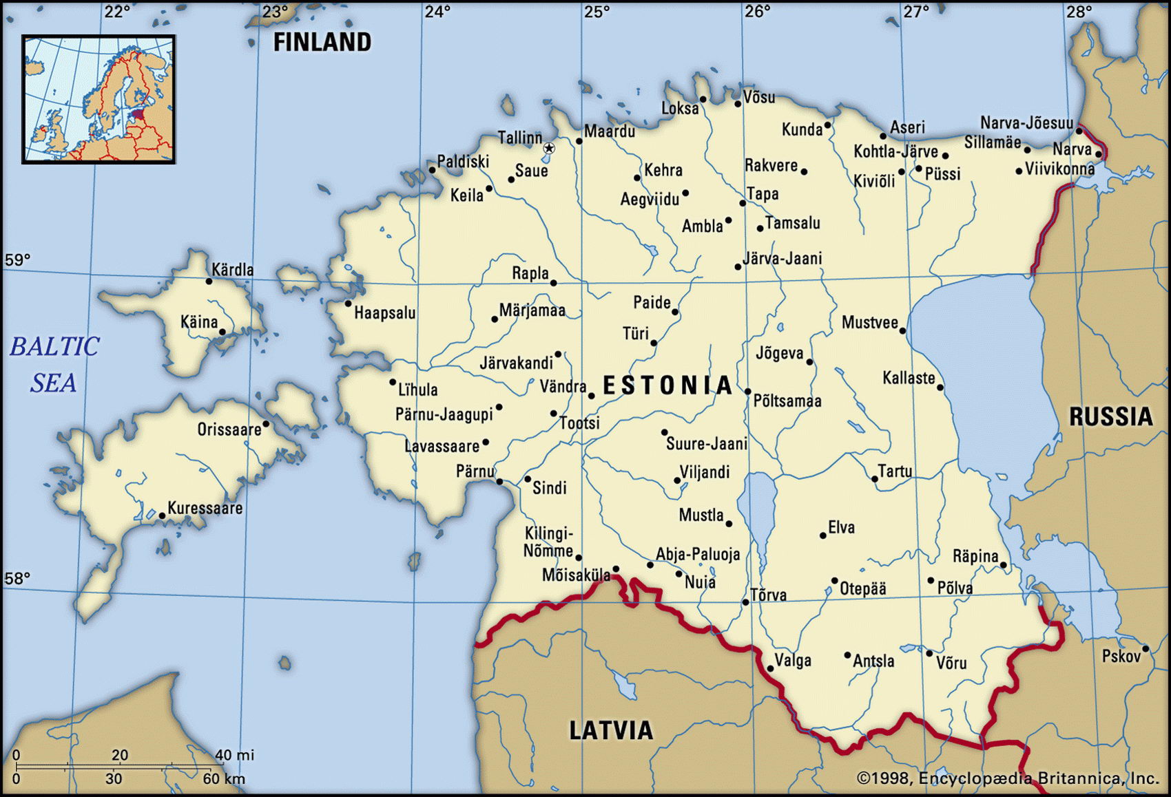
Map of Estonia and geographical facts
Estonia on the world map. Map of Estonia
Map of Estonia with cities. Where Estonia is on the world map. The main geographical facts about Estonia - population, country area, capital, official language, religions, industry and culture.

Estonia Fact File
Official name Republic of Estonia
Form of government Republic with single legislative body (Parliament)
Capital Tallinn
Area 45,100 sq km (1 7,41 3 sq miles)
Northern Europe
Time zone GMT + 3 hours
Population 1,416,000
Projected population 2015 1,190,000
Population density 31.4 per sq km (81.3 per sq mile)
Life expectancy 70.0
Infant mortality (per 1,000) 12.3
Official language Estonian
Other languages Latvian, Lithuanian, Russian
Literacy rate 100 %
Religions Lutheran 96%; Eastern Orthodox and Baptist 4%
Ethnic groups Estonian 61.5%, Russian 30.3%, Ukrainian 3.2%, Belarusian 1.8%, Finnish 1.1 %, other 2.1 %
Currency Kroon
Economy Industry 65%, services 28%, agriculture 7% GNP per capita US$ 10,900
Climate Cool temperate; cold winters and mild summers Highest point Mt Munamagi 318 m (1,043 ft) Map reference Page 287
It has been claimed that Estonia's flag, consisting of a blue, a black, and a white horizontal bar, represents the country's blue skies, black soils, and snowy winters. This, the smallest and least populous of the three Baltic countries, contains more than 1,500 lakes within its borders and its land area includes more than 800 islands in the Baltic Sea and the Gulf of Finland. The largest of the lakes, Lake Peipus, is in the far east of the country and forms most of its border with Russia.
Russia has been the dominant power in Estonia's recent history and the large ethnic Russian minority bears witness to this. From the thirteenth until the eighteenth century the Estonians were ruled by outsiders, first the Germans and then the Swedes. In 1721 Russia assumed control and ruled the country for almost 200 years. Occupied by Germany during the First World War, Estonia declared its independence in 1918. This was achieved in 1920 when, after an armed struggle, Russia
The medieval rooftops of Tallinn, the capital of Estonia (above). Savonlinna, a city on the Finnish Seenplatte, in the foreground the fortress Olavinlinna (below). The harbor of Stockholm, Sweden (left page).
formally recognized the small country. It was a short-lived victory, however. During the Second World War Estonia was overrun first by the Russians and then by the Germans. In 1944 it was returned to the Soviets and remained part of the USSR until it once again declared itself independent in August 1991, following Lithuania's example of the previous year. Since 2004 Estonia has been a member of the EU.
Most of Estonia is low-lying and flat or gently undulating. Large areas of land are barren and stony, a legacy of the glaciers that once covered much of the landscape. There are extensive woodlands which supply the raw materials for the country's important timber and woodworking industries. Engineering and textile manufacture are also significant. Despite its black soils, little of the land is arable and the main agricultural industries are dairying and livestock raising, especially pig farming. Mineral resources are meager, though extensive deposits of shale are used in the production of gas and chemical products.
Compared with other former Soviet republics, the people of Estonia enjoy a high standard of living. The economy, after declining for some years following independence, has improved steadily as increasing trade with Western countries has shielded Estonia from some of the effects of the declining Russian economy.