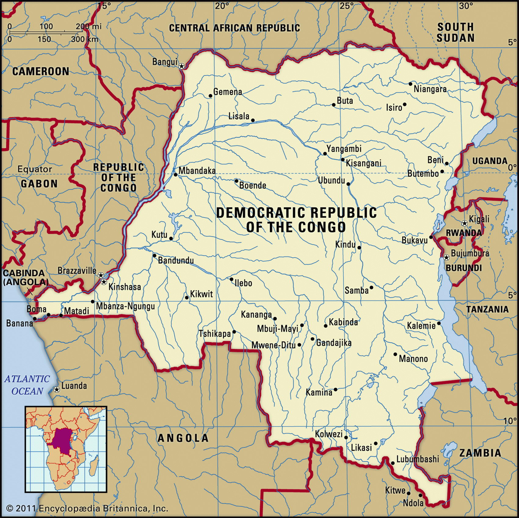
Map of Democratic Republic of the Congo and geographical facts
Democratic Republic of the Congo on the world map
Map of Democratic Republic of the Congo with cities. Where Democratic Republic of the Congo is on the world map. The main geographical facts about Democratic Republic of the Congo - population, country area, capital, official language, religions, industry and culture.

Democratic Republic of Congo Fact File
Official name Democratic Republic of the Congo Form of government Presidential rule Capital Kinshasa
Area 2,345,410 sq km (905,563 sq miles)
Time zone GMT + 1/2 hour
Population 55,226,000
Projected population 2015 84,045,000
Population density 23.5 per sq km (61.0 per sq mile)
Life expectancy 49.1
Infant mortality (per 1,000) 98.1
Official language French
Other languages Lingala, Kingwana, Kikongo, Tshiluba Literacy rate 77.3%
Religions Roman Catholic 50%, Protestant 20%, Kimbanguist 10%, Muslim 10%, other indigenous beliefs 10%
Ethnic groups More than 200 indigenous groups, mostly of Bantu origin: Kongo, Luba, Mongo, Mangbetu-Azande 51%; other 48%
Currency New zaire
Economy Agriculture 72%, services 15%, industry 13%
GNP per capita US$ 590
Climate Tropical; wet season north of equator from April to October, wet season south of equator from November to March
Highest point Mt Stanley 5,110 m (16,765 ft)
Map reference Pages 368-69
The Democratic Republic of the Congo (DRC), formerly called Zaire, is the centerpiece of central Africa. It is the third-largest country on the continent after Algeria and Sudan and has one of the largest navigable rivers in the world. Historically occupied by the Kongo, Luba, Lunda, and Azande peoples, this enormous region fell into the hands of King Leopold of Belgium in 1885, who exploited it as a private domain. After international condemnation of his brutal rule, in 1908 it became a colony of Belgium. The country won its independence in I960.
Since that time, 35 years of dictatorial mismanagement and corruption as a one-party state under the control of President Mobutu Sese Seko (who died in 1997) have brought the DRC to the point of collapse. The troubles of its neighbors have added to its own. War and disorder in Sudan, Rwanda, Burundi, and Angola have driven hundreds of thousands of refugees across the borders into the DRC. A military occupation of Kinshasa was successful in bringing the Mobutu regime to an end in 1997. His successor, President Laurent Kabila was assassinated in 2001 and succeeded by his son Joseph. In 2003 the EU dispatched troups to the country to help. Whether the current government of national unity will be successful remains to be seen.
Geographically the DRC is dominated by a single feature—the immense basin of the Congo River. The eastern rim of this basin is formed by the Mitumba Mountains (Monts Mitumbe) along the Rift Valley, and the volcanic Ruwenzori Range. In the far southeast Lake Mweru feeds into the Congo's main northward-flowing tributary, the Lualaba. Looping north and west in a great horseshoe, the Congo is joined on the borders of the Central African Republic by the Ubangi. After several cascades below Kinshasa as it descends from the central plateau, the Congo empties into the Atlantic Ocean. The equatorial climate of the main river basin supports one of the world's most extensive rainforests, home to rare animals such as okapi and gorilla. The savanna grasslands of the east and south are home to giraffe, lion, antelope and rhinoceros.
Potentially one of Africa's richest countries, the DRC is currently one of its poorest. Most of its people try to survive the breakdown of civil society by subsistence farming and petty trade. Cash crops such as coffee, sugar, and palm oil continue to be produced, but a severe lack of infrastructure hampers trade. Meanwhile, hyperinflation, large government deficits, and falling mineral production mean that no end to the nation's economic difficulties is yet in sight.