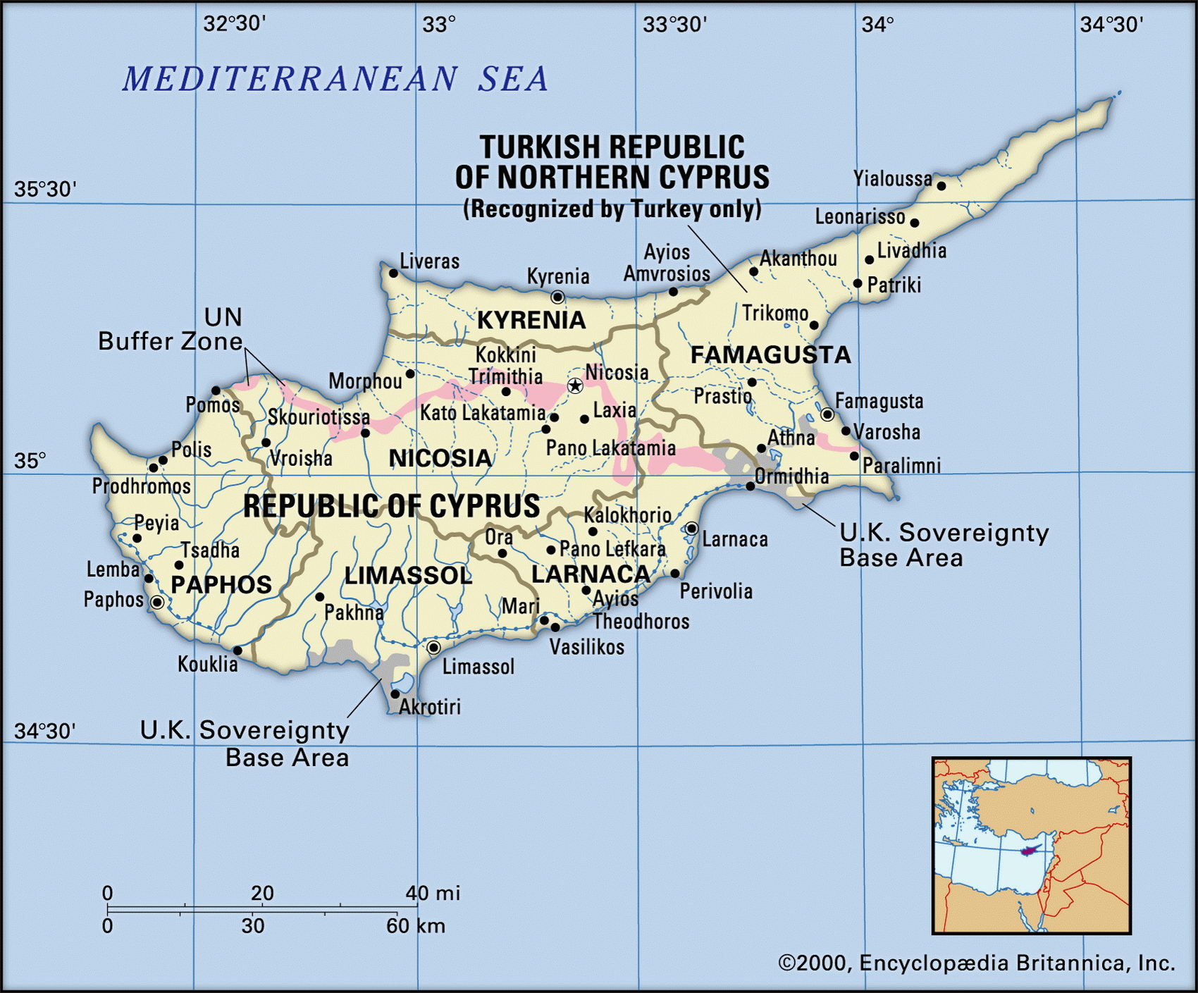
Map of Cyprus and geographical facts
Cyprus on the world map. Map of Cyprus
Map of Cyprus with cities. Where Cyprus is on the world map. The main geographical facts about Cyprus - population, country area, capital, official language, religions, industry and culture.

Cyprus Fact File
Official name (Greek/Turkish) Republic of Cyprus
Region Central and West Asia
Form of government Two de facto republics each with single legislative body: House of Representatives in Greek area. Assembly of the Republic in Turkish area
Capital Lefkosia (Nicosia)
Area 9,250 sq km (3,571 sq miles)
Time zone GMT + 2 hours
Population 768,000
Projected population 2015 864,000
Population density 83 per sq km (215.1 per sq mile)
Life expectancy 77.1
Infant mortality (per 1,000) 7.7
Official languages Greek, Turkish
Other language English
Literacy rate 97 c.
Religions Greek Orthodox 78%, Muslim 18%, other 4 %
Ethnic groups Greek 78%, Turkish 18%, other 4 %
Currency Cypriot pound, Turkish lira
Economy Services 67%, industry 19%, agriculture 14%
GNP per capita US$ 15,000 (Greek part of the island), US$ 7,000 (Turkish part of the island)
Climate Temperate, with cool, wet winters and warm, dry summers
Highest point Olympos 1,951 m (6,404 ft) Map reference Page 224
Cyprus takes its name from "kypros," the Greek word for copper. It was an important metal 3,000 years ago, in classical times, and is still exported today. Occupied by a succession of Phoenicians, Greeks, and Romans, held from 1571 by the Turks and by the British from 1878, Cyprus today is a deeply divided island. The southern part forms the Republic of Cyprus proper, where most of the population lives. Since 1982 the northern part has consisted of an autonomous region calling itself the Turkish Republic of Northern Cyprus (see box). The Greek part of the island became part of the EU in 2004 after voting down reunification with the Turkish north.
Along the north coast runs the long limestone range of the Kyrenia Mountains. Just south of this range is the fertile Mesaoria Plain between Morphou and Ammochostos (Famagusta) where grapes, potatoes, citrus fruits, and cereals are grown, and the steeper land supports sheep, goats, and cattle. In the south is the broad, mineral-rich massif of Troodos, which contains the copper. This constitutes fifty percent of the country's total land area and is a good geological example of an ophiolite, a dome of mineral-rich sub-oceanic rocks. Both major rivers flow from this massif— the Pedieas to Ammochostos Bay (Famagusta Bay), the Karyoti to Morphou Bay. Nearly half the total area of Cyprus is arable and twenty percent of this is irrigated.
The gap between the economic fortunes of the two parts of Cyprus continues to grow wider. The agriculturally based Turkish north, severely disrupted by the events of 1974, has not recovered well, and has suffered considerably from inflation. It continues to produce some cereals, meat, fruits, and olives. The Greek Cypriot southern half of the island has prospered from a greater diversity of activities, including tourism, manufacturing, and the income from military installations, such as the British air base of Akrotiri near Limassol. Manufactured products include cigarettes, wine, clothing, footwear, and cement.
The Cyprus question
The Cypriots were among the first Christians. Between 644 and 975 the island was attacked and invaded multiple times in the course of the expansion of Islam. In 1195, after the Thrid Crusade, the island was awarded to the family of Guy de Lusignan as recompensation for his loss of the crown of Jerusalem. In 1487 the island came under the tutelage of the Venetians.
In 1571 the Ottomans conquered the island and slew many of its Greek inhabitants before they settled their own countrymen there. With the decline of the Ottoman Empire in the nineteenth century, a treaty was concluded with the United Kingdom that handed control of the islands over to the British crown (in 1925 Cyprus became an official colony). Soon the Greek Cypriots started to advocate the unification of the island with Greece. This was supported by the leaders of the Greek Orthodox church who argued that eighty percent of the population wanted to
become part of the "mother country". In 1931 fighting broke out in Nicosia. After the Second World War the claim for unification was renewed. The political situation became even more explosive when another Greek group appeared who opted for the independence of the island.
In 1960 Cyprus became independent but soon new fights broke out. For ten years Greeks and Turks contested for suppremacy. In 1974 Turkish troups invaded the north of the island and occupied forty percent of the island, expelling approximately 200,000 Greeks to the south. Nine years later Northern Cyprus declared its independence. It was only recognized by Turkey and is ruled by a government headed by a president. A great opportunity to reunite the two halves was voted down by the population of the Greek part of the island shortly before Greek Cyprus joined the EU in 2004; whether this will change in the near future remains doubtful.