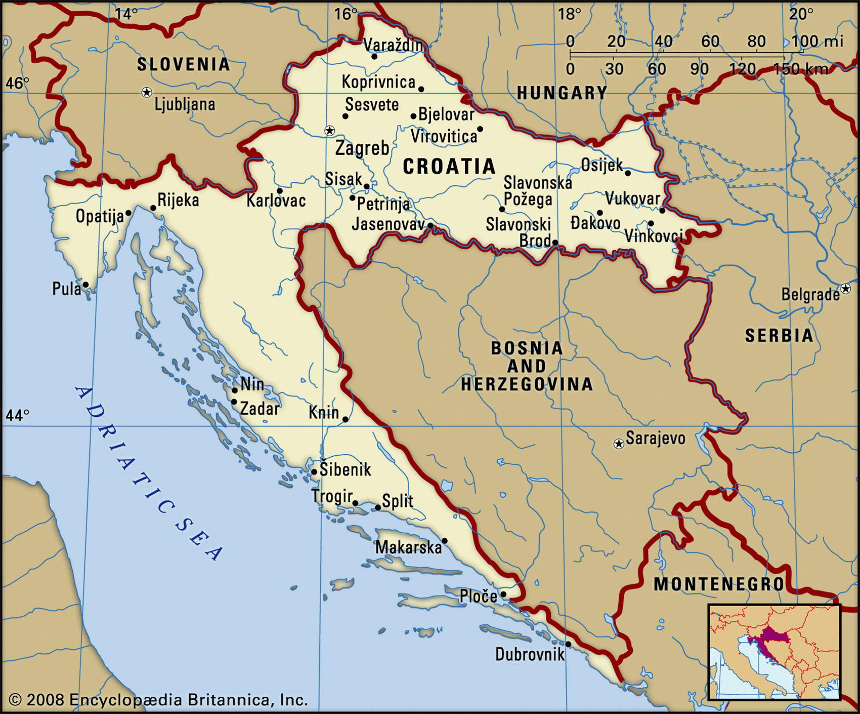
Map of Croatia and geographical facts
Map of Croatia. Croatia on the world map
Map of Croatia with cities. Where Croatia is on the world map. The main geographical facts about Croatia - population, country area, capital, official language, religions, industry and culture.

Croatia Fact File
Official name Republic of Croatia
Form of government Republic with two legislative bodies (House of Districts and House of Assembly)
Capital Zagreb
Area 56,538 sq km (21,829 sq miles)
Time zone GMT + 1 hour
Population 4,391,000
Projected population 2015 4,622,000
Population density 77.7 per sq km (201.2 per sq mile)
Life expectancy 74.1
Infant mortality (per 1,000) 7.1
Official language Croatian
Other languages Serbian, languages of the minorities
Literacy rate 97%
Religions Catholic 76.5%, Orthodox 11.1 %, Slavic Muslim 1.2%, Protestant 0.4%, others 10.8%
Ethnic groups Croat 78%, Serb 12%, Muslim 0.9%, Hungarian 0.5%, Slovene 0.5%, others 8.1 %
Southeastern Europe
Currency Kuna
Economy Services 64.6%, industry 31.1 %, agriculture 4.3%
GNP per capita US$ 8,800
Climate Temperate; cold winters and warm summers inland, cooler and more temperate along coast
Highest point Dinara 1,830 m (6,004 ft)
Map reference Pages 294, 296
Croatia wraps around the northern and western extremities of Bosnia and Herzegovina, allowing its neighbor a tiny 20 km (12 mile) toehold south of its almost 600 km (375 mile) stretch of coastline on the Adriatic Sea. It also shares borders with Slovenia to the northwest, Hungary to the northeast, and Serbia and Montenegro to the east. The state of Croatia emerged in the ninth century ad, peopled by Slavic immigrants from present-day Ukraine. In 1091 it was invaded by Hungary with which it remained united until 1526 when most of the country came under the rule of the Ottoman Turks. In 1699 the Turks were driven out by the Austrian Habsburgs. Once again Croatia came under Hungarian rule, but with its own monarch. In 1867 Croatia became part of the Austro-Hungarian Empire. In 1918 it declared its independence and joined with its neighboring states to form the Kingdom of Serbs, Croats, and Slovenes—the precursor of the state of Yugoslavia. Serbian domination of the new country provoked agitation by Croation separatists, and in 1939 this led to Croatia's being declared a self-governing region within Yugoslavia. During the Second World War, the invading Axis powers proclaimed Croatia an independent state and installed a Fascist government intent on eliminating Serbs, Jews, and all political oppostion. At the war's end, Croatia once again became a republic in the reformed state of Yugoslavia. In 1991, after a referendum, Croatia declared its independence and was then plunged into civil war as Croatian Serbs, supported by the Yugoslav army, sought to incorporate Croatia into a "Greater Serbia." The war ended officially in 1992, but hostilities between Serbs and Croats continued until 1995.
Along Croatia's spectacular Dalmatian coast are scattered about 600 small rocky islands, many of them former alpine peaks, isolated by rises in sea level. Further inland in the north, the Pannonian Plain, traversed by the Drava, Danube, and Sava Rivers, is a fertile region centered around Zagreb, which is the hub of the country's agricultural production. A little more than one-fifth of the land is devoted to agriculture and about one-fifth of the population is directly involved in agricultural production. Cereal crops, fruit, and tobacco are widely grown and sheep are raised. Timber is a significant resource, and reserves of minerals, coal and iron are mined. Civil and other regional wars in the 1990s have seriously impeded Croatia's transition to a market economy and cut industrial production. The tourist industry, once of great economic significance, had largely ceased to exist in the early 1990s. However, following huge efforts to eliminate the destructions of war it is on the rise again.