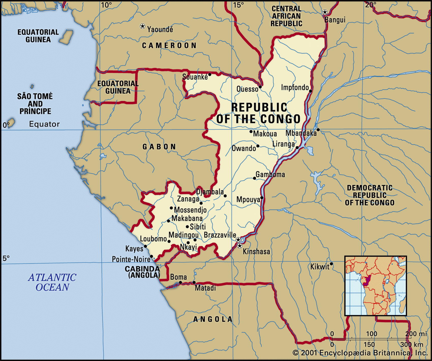
Map of Congo and geographical facts
Congo on the world map. Map of Congo
Map of Congo with cities. Where Congo is on the world map. The main geographical facts about Congo - population, country area, capital, official language, religions, industry and culture.

Congo Fact File
Official name People's Republic of the Congo
Form of government Republic with two legislative bodies (Senate and National Assembly)
Capital Brazzaville
Reion Central Africa
Area 342,000 sq km (1 32,046 sq miles)
Time zone GMT + 1 hour
Population 2,959,000
Projected population 2015 4,730,000
Population density 7.9 per sq km (22.4 per sq mile)
Life expectancy 47.7
Infant mortality (per 1,000) 97.9
Official language French
Other languages African languages (particularly Lingala, Kikongo and Monokutuba)
Literacy rate 74.9 %
Religions Christian 50%, indigenous 48%, Muslim 2%
Ethnic groups About 75 different tribes: Kongo 48 %, Sangha 20 %, Teke 1 7 %; other 15 %
Currency CFA (Communaute Financiere Africaine) franc
Economy Agriculture 75 %, industry and services 25 %
GNP per capita US$ 900
Climate Tropical, with wet season March to June
Highest point Mt Berongou 903 m (2,963 ft)
Map reference Page 368
From the Atlantic coast, Congo extends 1,000 km (600 miles) inland to the border of the Central African Republic. Its history is obscure, although the first inhabitants may have been Pygmies. Later it was home to the Kongo peoples who supplied slaves for Portuguese traders. In the nineteenth century it was explored by the French-Italian Pierre Savorgnan de Brazza, who gave his name to the capital city, and whose activities led to the region becoming part of French Equatorial Africa in 1891. Congo has been independent since I960. Ten years after independence, Congo declared itself a People's Republic and Africa's first communist state. Since 1991, however, there have been attempts to introduce the principles of legal opposition and multi-party democracy. In 1997 a brief civil war restored former Marxist President Sassou-Nguesso, but also started a five-year period of ethnic unrest. Finally, in March 2003 southern-based rebel groups agreed to a peace accord.
Road transport within Congo is hampered by tropical rains that make the unpaved roads un-useable but water transport to the interior and the northeast is comparatively easy. Two mighty rivers, the Congo and the Ubangi, provide a commercially navigable highway along virtually the entire eastern frontier.
From a coastal strip on the Atlantic seaboard, the Rivers Kouilou and Niari lead up to the heights of the Massif du Mayombe. This range is crossed by a spectacular French-built railway joining Brazzaville with the port of Pointe-Noire. The Congo below Brazzaville has many cataracts, and the railway was built to carry freight around them. Beyond the massif the land falls away northward to the central plateau, where numerous rivers drain east into the Ubangi and the Congo itself.
Though more than half the Congolese live in towns, subsistence agriculture engages one-third of the workforce, and most of the food produced and consumed is cassava. Rice, maize, and vegetables are also grown, and coffee and cocoa are exported. Some sixty percent of the country is still covered in tropical forest. Timber was once a leading export, but today ninety percent of exports consists of oil. Apart from that, Congo allows other countries such as Gabon or the Central African Republic to use its port and other transport facilities. Manufacture, for example the processing of agricultural products or the production of textiles and shoes in the larger cities, is also an economic enterprises of some importance. Despite its comparative wealth, the government has mortgaged a large part of its oil earnings for expensive development projects.