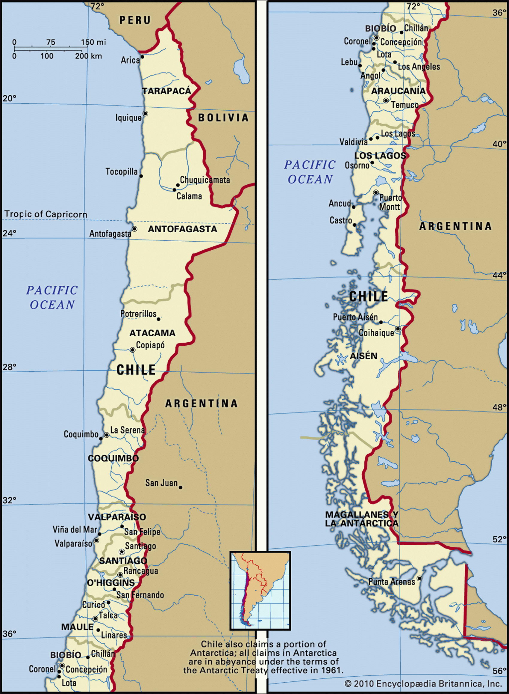
Map of Chile and geographical facts
Chile on the world map. Map of Chile with cities
Map of Chile with cities. Where Chile is on the world map. The main geographical facts about Chile - population, country area, capital, official language, religions, industry and culture.

Chile Fact File
Official name Republic of Chile
Form of government Republic with two legislative bodies (High Assembly and Chamber of Deputies)
Capital Santiago
Area 756,950 sq km (292,258 sq miles)
Time zone GMT-4 hours
Population 15,499,000
Projected population 2015 17,912,000 Population density 20.0 per sq km (53 per sq mile) Life expectancy 76.1 Infant mortality (per 1,000) 9.1
Official language Spanish
Literacy rate 95.2 %
Religions Roman Catholic 89%, Protestant 11 %
Ethnic groups European and mixed indigenous-European 95%, indigenous 3%, other 2%
Currency Chilean peso
Economy Services 63 %, agriculture 19 %, industry 18 %
GNP per capita US$ 10,000
Climate Arid in north, cold and wet in far south, temperate elsewhere
Highest point Ojos del Salado 6,880 m (22,572 ft) Map reference Pages 458, 460
Chile lies between the Andes and the sea. It stretches 4,350 km (2,700 miles) along South America's Pacific coast, yet is never more than 180 km (110 miles) wide. In the fifteenth century,
the Incas from Peru tried but failed to subjugate its Araucanian Indian population. This was gradually achieved by the Spanish, against strong resistance, after their arrival in the sixteenth century. The Spanish established mining in the north and huge estates in the Central Valley; by the nineteenth century produce was being exported to California, Australia and elsewhere. Today, fruit and vegetables remain important exports, along with wine.
The Atacama Desert (Desierto de Atacama), in the north, has one of the lowest rainfalls in the world. In the nineteenth century it was the world's main source of nitrate for fertilizer, an export which underwrote Chile's early economic development. Santiago and the port of Valparaiso form an urban cluster midway along the length of the country. Santiago lies in a sheltered, temperate valley between a coastal range of mountains to the west and the high Andes in the interior. This fertile 800 km (500 mile) valley is where Chile's main vineyards are located, and where sixty percent of the population live. It is also where most manufacturing industry is located. Volcanoes, active and inactive, mark the length of the Chilean Andes to the east. In the southern third of the country the coastal range disintegrates into a maze of islands, archipelagoes, and fiords.
In 1970 President Allende nationalized the copper industry and other large enterprises, raised wages, and fixed prices. By 1973 inflation had reached 850 percent. Fearing a Cubanization of Chile, the political right under General Pinochet staged a coup and ruled for the next seventeen years. During that time, over 2,000 political opponents "disappeared". Economically, the coup's effects were positive. The regime restored economic liberalism and dismantled state controls. Democracy was restored at a general election in 1989.
After two decades of political turmoil, Chile is now one of the more economically progressive of South America's democracies. It is the world's leading supplier of copper, and high copper prices remain vital to the nation's economic health. Growth in gross domestic product averaged more than six percent annually from 1991 to 1995, and in recent years an estimated 1 million Chileans have ceased to be classed as poor.