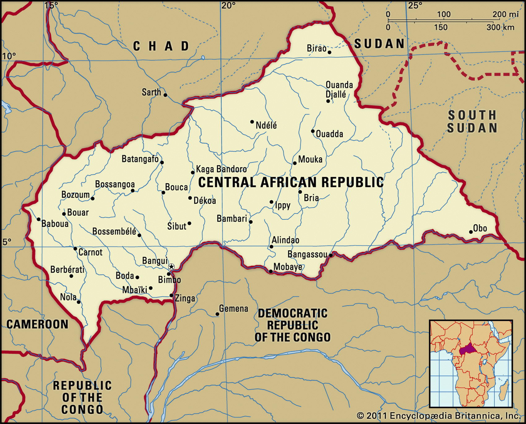
Map of Central African Republic and geographical facts
Central African Republic on the world map
Map of Central African Republic with cities. Where Central African Republic is on the world map. The main geographical facts about Central African Republic - population, country area, capital, official language, religions, industry and culture.

Central African Republic Fact File
Official name Central African Republic
Form of government Republic with single legislative body (National Assembly)
Capital Bangui
Area 622,980 sq km (240,533 sq miles)
Time zone GMT + 1 hour
Population 3,643,000
Projected population 2015 4,877,000
Population density 5.8 per sq km (15.1 per sq mile)
Life expectancy 43.6
Infant mortality (per 1,000) 92.2
Official language French
Other languages Sangho, Arabic, Hunsa, Swahili
Literacy rate 60 %
Religions Protestant 25 %, Roman Catholic 25 %, indigenous beliefs 24%, Muslim 15 %, other 11 %
Ethnic groups Baya 34%, Banda 27%, Mandjia 21' Sara 10%, Mboum 4%, M'Baka 4%
A small village on Cameroon's arid savanna (left page bottom). Falls on the Kotto River in the Central African Republic (left).
Currency CFA (Communaute Financiere Africaine) franc
Economy Agriculture 84%, services 13%, industry 3%
GNP per capita US$ 1,300
Climate Tropical, with hot, dry winters and hot, wet summers
Highest point Mt Kayagangir 1,420 m (4,659 ft) Map reference Pages 365, 366
The Central African Republic (CAR) is a landlocked plateau just north of the equator. It is bordered on the west and north by Cameroon and Chad, and on the east and south by Sudan, the Democratic Republic of Congo, and Congo. By the time of European exploration the population of forest-dwelling Pygmies was much reduced, having been largely replaced by Bantu and Azande people. The region was for centuries used as a slave source by African slave-traders from the Sudan. When France took control in 1911 it ended slave-trading. The CAR was run as part of French Equatorial Africa until independence in 1958. After thirty years of political instability and military governments civilian rule was established in 1993- In March 2003 a military coup deposed the civilian government. Even though civil society groups and the main parties support the transitional government there is doubt whether the elections scheduled for 2004 or 2005 will be democratic. The government still does not fully control the countryside, where pockets of lawlessness persist.
The average elevation of the CAR plateau is between 2,000 and 2,500 m (6,500 and 8,000 ft). These uplands form a watershed dividing the Congo and Nile river basins. North of the high ground of the Massif des Bongos the land drains towards the interior along water courses into swamps in southern Chad. South of this massif numerous rivers feed into the Ubangi. To the west the Massif du Yade forms a boundary with Cameroon.
In the south and southeast are forests containing hardwoods such as mahogany and ebony. Dense rainforest in this area provides one of the last homes of the lowland gorilla. Much of the rest of the land is savanna. Plantation forestry undertaken by foreign timber interests has in some places added significantly to natural soil erosion.
The CAR economy is based on subsistence agriculture combined with forestry. Food crops include manioc, yams, millet, maize, and bananas. Cotton, coffee, and tobacco are grown for cash. Industries include sawmills, textiles, footwear, and bicycle assembly. About eighty percent of export revenue comes from diamond mining.
The country's economic prospects are constrained by its position, its limited resources, its unskilled workforce, and its poor infrastructure. In addition, tuberculosis, leprosy, and sleeping sickness are widespread. These factors are likely to keep the CAR dependent on foreign aid for some time.