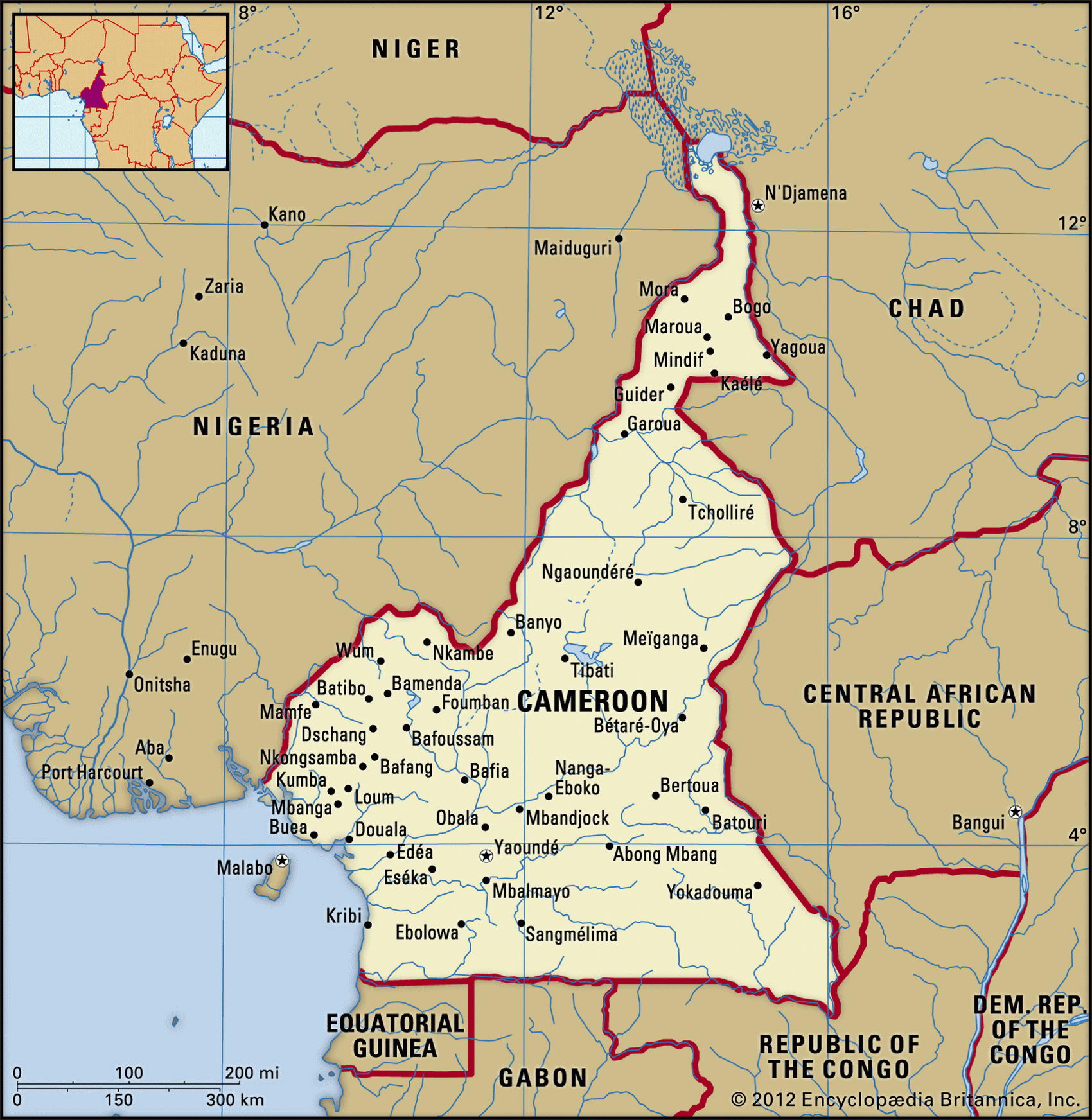
Map of Cameroon and geographical facts
Cameroon on the world map. Map of Cameroon
Map of Cameroon with cities. Where Cameroon is on the world map. The main geographical facts about Cameroon - population, country area, capital, official language, religions, industry and culture.

Cameroon Fact File
Official name Republic of Cameroon
Form of government Republic with single legislative body (National Assembly)
Capital Yaounde
Area 475,440 sq km (183,567 sq miles)
Time zone GMT + 1 hour
Population 16,185,000
Projected population 2015 20,226,000
Population density 34 per sq km (88.2 per sq mile)
Life expectancy 54.4
Infant mortality (per 1,000) 68.8
Official languages French, English
Other languages 24 African languages
Literacy rate 63.4%
Religions Indigenous beliefs 51 %, Christian 33%, Muslim 16%
Ethnic groups Cameroon Highlanders 31 %, Equatorial Bantu 19%, Kirdi 11 %, Fulani 10%, Northwestern Bantu 8%, Eastern Nigritic 7%; other African 1 3 %; non-African 1 %
Currency CFA (Communaute Financiere Africaine) franc
Economy Agriculture 74.4%, industry and transport 11.4 %, services 14.2 %
GNP per capita US$ 1,700
Climate Tropical in south and along coast, semiarid in north
Highest point Mt Cameroon 4,095 m (13,435 ft) Map reference Page 365
The African state of Cameroon is on the Gulf of Guinea, with Nigeria to the west and Equatorial Guinea, Gabon, and Congo to the south. The Portuguese arrived in 1472, and Cameroon is named after the prawns, camardos, they found here. A German colony from 1884, and later ruled by both British and French, Cameroon became independent in I960. Although it was a one-party state for thirty years, opposition parties have been allowed since 1991. One of the more prosperous African countries, Cameroon is home to more than 200 distinct tribes and peoples. There is also a broad distinction between the English- and French-speaking parts of the population. In response to the demands of the former, and the protests and demonstrations they made in 1996, Cameroon applied for entry and was admitted to the British Commonwealth.
The country can be divided into four regions. First, an area of tropical forest, plateau, and coastal plain extends from the southern frontier to the Sanaga River. Most of the population is concentrated in this southern part. Second, north of this river and Lake Mbakaou (M'Bakaou Reservoir), the land rises to the highlands of the Adamaoua Massif. Third is the mountainous western extension of the Adamaoua Massif which includes Mt Cameroon. Occasionally active, this 4,095 m (13,435 ft) volcanic cone is the highest mountain in west Africa. Fourth is the arid savanna north of the Benue (Benoue River) and towards Lake Chad (Lac Tchad). This region of savanna supports elephant, lion, and leopard, and a national park—the Pare National de la Benoue—has been established there.
Cameroon's prosperity was helped by the oil boom between 1970 and 1985. Since then conditions have been more difficult, with prices for coffee, cocoa, and petroleum, the country's major exports, falling. Three-quarters of the population are farmers who, in addition to coffee and cocoa, grow bananas, oilseed, grains, and manioc. Cameroon is self-sufficient in food, but a range of other economic difficulties exists. Serious inflation occurred in 1994. The dismantling of unproductive state industries has been slow to show results, and the swollen ranks of the civil service remain a fiscal burden.