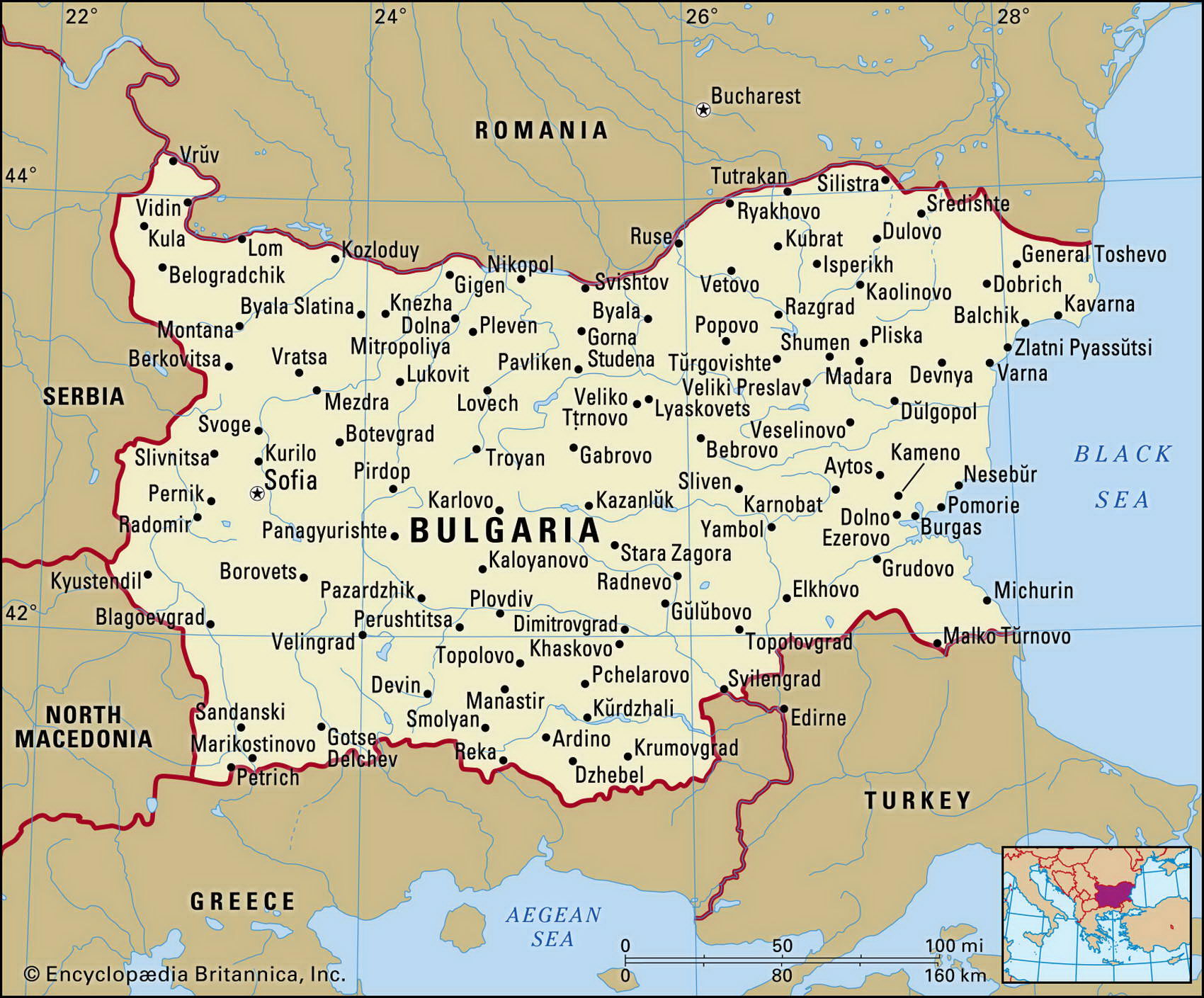
Map of Bulgaria and geographical facts
Bulgaria on the world map. Map of Bulgaria
Map of Bulgaria with cities. Where Bulgaria is on the world map. The main geographical facts about Bulgaria - population, country area, capital, official language, religions, industry and culture.

Bulgaria Fact File
Official name Republic of Bulgaria
Form of government Republic with single legislative body (National Assembly)
Capital Sofia
Area 110,910 sq km (42,822 sq miles)
Time zone GMT + 2 hours
Population 7,621,000
Projected population 2015 6,816,000
Population density 68.7 per sq km (1 78 per sq mile)
Life expectancy 71.5
Infant mortality (per 1,000) 14.2
Official language Bulgarian
Other languages Turkish, Romany
Literacy rate 98c.
Religions Bulgarian Orthodox 85%, Muslim 13c Jewish 0.8%, Roman Catholic 0.5%, Uniate Catholic 0.2%; Protestant, Gregorian-Armenian and other 0.5%
Ethnic groups Bulgarian 85.3%, Turkish 8.5%, Gypsy 2.6%, Macedonian 2.5%, Armenian 0.3°/ Russian 0.2%, other 0.6%
Currency Lev
Economy Services 45%, industry 38%, agriculture 17%
GNP per capita US$ 6,600
Climate Temperate, with cold, wet winters and hot, dry summers
Highest point Mt Musala 2,925 m (9,596 ft) Map reference Pages 296-97
Bulgaria is situated on the east of the Balkan Peninsula with a coastline along the Black Sea. To the west it shares borders with Serbia and Montenegro as well as Macedonia. Turkey lies to its southeast, and Greece to its southwest. In the north the River Danube forms most of the border between Bulgaria and Romania.
Modern Bulgarians are descendants of the Bulgars, who arrived from north of the Danube in the late seventh century ad and established dominance over the Slavic races that had settled the area over the previous two centuries. The Christian religion, which is still dominant in the country, was established in the ninth century. A century of Byzantine domination in the eleventh and twelfth centuries was followed by a period of independence. In 1396 Turkish armies invaded and Bulgaria was then dominated for five centuries by the Turks until Russian intervention ended Ottoman rule in 1878. Full independence, however, did not come until 1908, when Prince Ferdinand of Saxe-Coburg, the elected ruler of Bulgaria, assumed the title of Tsar.
Bulgaria sided with the losing sides in both the First and Second World Wars, and as a result its boundaries changed several times as territories were ceded to it or confiscated. Its present boundaries were established by a 1947 treaty. From then until the fall of the Soviet Union in the early 1990s, Bulgaria remained one of the most loyal of Soviet satellites. A new constitution came into force in 1991 and the following year the first free elections were held.
The country's landscape is defined by three ranges of mountains and two extensive expanses of lowland. The Danube Valley is the country's richest agricultural area, producing significant yields of wheat, maize, and other cereal crops. The Balkan Mountains, running east-west across much of central Bulgaria, reach heights of up to 2,000 m (6,500 ft). They divide the Danube Valley from the southern lowlands, where tobacco and grapes are among the principal crops in the fertile valleys around the Maritsa River. The vineyards in this region produce some of southern Europe's finest wines. In the southwest the Rhodopi Massif, which contains the country's loftiest peak, forms the mountainous border with Greece.
More than ten million tourists, attracted to its Black Sea coastline, come to Bulgaria each year and contribute significantly to its economy. Most of the country's export earnings stem from its machinery and other manufacturing industries. While there have been tentative moves towards the establishment of a free market economy, high inflation, foreign debt, and worker unrest have contributed to a far from robust short-term economic outlook.