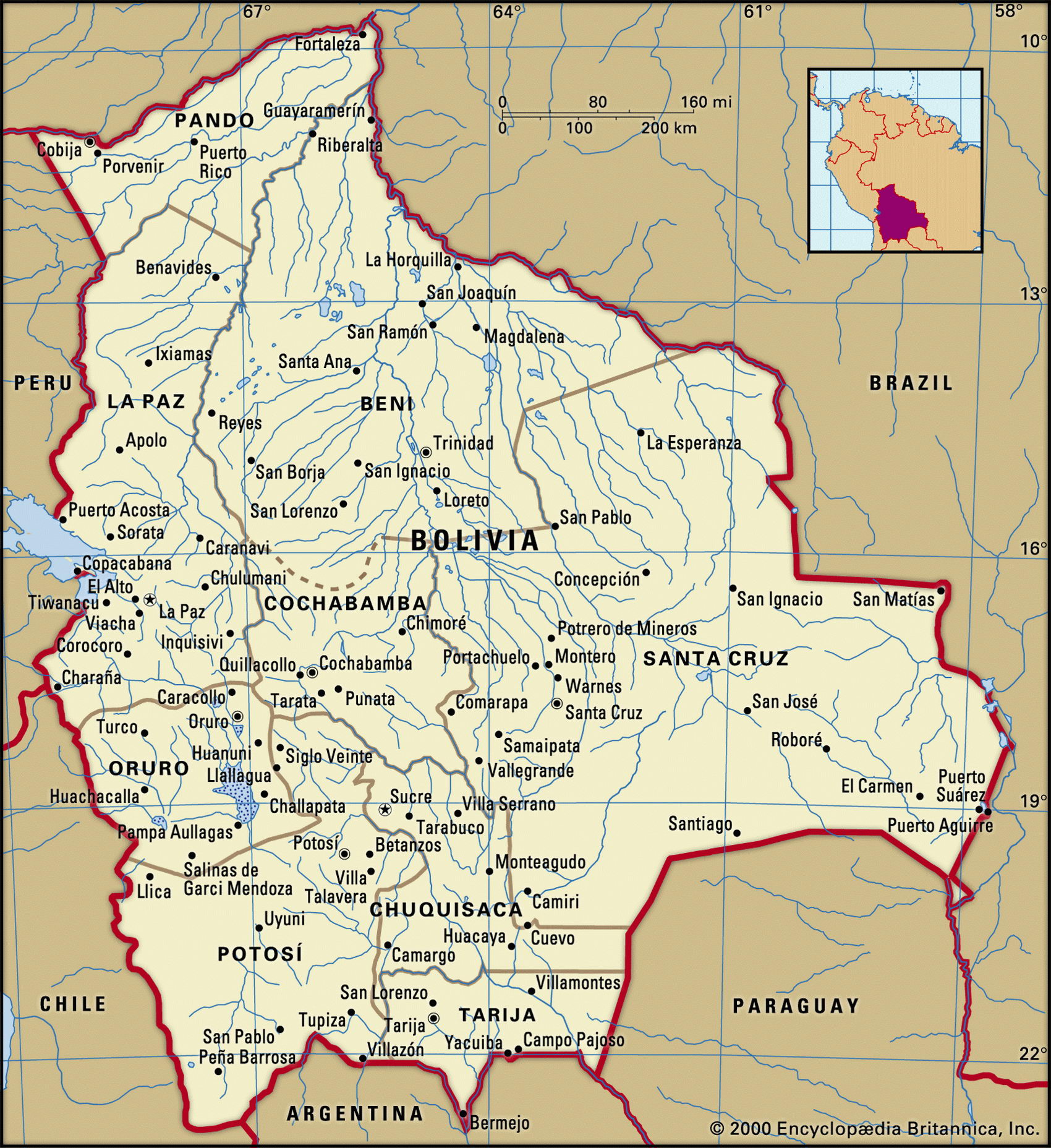
Map of Bolivia and geographical facts
Bolivia on the world map. Map of Bolivia
Map of Bolivia with cities. Where Bolivia is on the world map. The main geographical facts about Bolivia - population, country area, capital, official language, religions, industry and culture.

Bolivia Fact File
Official name Republic of Bolivia
Form of government Republic with two legislative bodies (Senate and Chamber of Deputies)
Capital Sucre (official); La Paz (administrative)
Area 1,098,580 sq km (424,161 sq miles)
Time zone GMT-4 hours
Population 8,445,000
Projected population 2015 11,218,000
Population density 7.7 per sq km (19.6 per sq mile)
Life expectancy 64.4
Infant mortality (per 1,000) 57.5
Official languages Spanish, Quechua, Aymara
Literacy rate 83.1 %
Religions Roman Catholic 95 %, other 5 %
Ethnic groups Quechua 30%, Aymara 25%, mixed indigenous-European 30%, European 15%
Currency Boliviano
Economy Agriculture 50%, services 36%, industry 14% GNP per capita US$ 2,600
Climate Tropical north and east; cold, arid west of Andes Highest point Nevado Sajama 6,520 m (21,391 ft) Map reference Page 455
High on the Altiplano, a plateau nearly 3,600 m (12,000 ft) above sea level, La Paz is the world's loftiest capital city. In the sixteenth century, when the Spanish conquistadores arrived in Bolivia, they found silver and the mine they established at Potosi soon became famous. But the silver boom passed, the prices for the minerals and metals that replaced it (mainly tin) have been volatile, and Bolivia is now South America's poorest nation. It is landlocked, and its rugged terrain makes it doubly inaccessible. Notorious for its political instability (192 coups between 1824 and 1981) and for the hyperinflation that rose to 11,700 percent in 1985, it now appears to have a democratic government that is trying to establish economic order.
Quechua and Aymara Indians together form 55 percent of the population. Subsistence farmers, they grow maize, potatoes, and coca on the Altiplano. This cold, treeless region runs 400 km (250 miles) north to south between two major Andean ranges. At its north, Indians still fish in Lake Titicaca from boats made of reeds. In the south are salt flats. The vegetation of the Altiplano is grassland which changes to scrubland at higher elevations. To the east lies the Oriente, reaching across the foothills and the plains. It includes the semi-arid Chaco of the southeast, the savanna of the center, and the plains of the northern forests whose rivers feed into the Amazon Basin.
The hyperinflation of the 1980s damaged the tin industry, causing the country to fall from first producer in the world to fifth. Government efforts reduced inflation to twenty percent by 1988, and to 9.3 percent by 1993. In the mid-1990s the state airline, railroad, and telephone companies were privatized, plus state mining and oil companies. Metals, natural gas, soybeans, and jewelry are the main exports but coca grown for cocaine may well surpass it—Bolivia is the world's second-largest cultivator of coca leaf. This affects foreign aid because the main donor, the USA, demands proof of Bolivian efforts to eradicate coca farms.