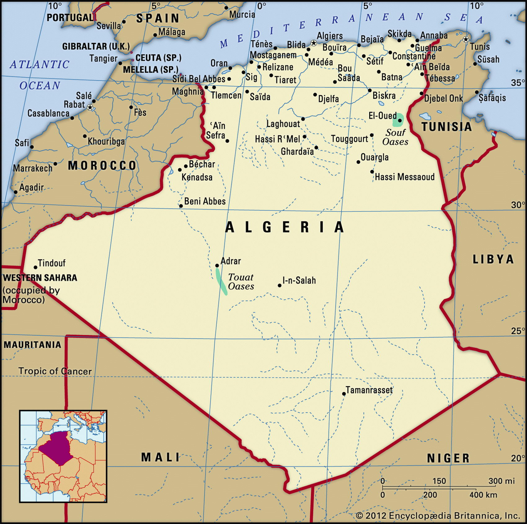
Map of Algeria and geographical facts
Algeria on the world map. Map of Algeria
Map of Algeria with cities. Where Algeria is on the world map. The main geographical facts about Algeria - population, country area, capital, official language, religions, industry and culture.

Algeria Fact File
Official name Democratic and Popular Republic of Algeria
Form of government Republic with single legislative body (National People's Assembly), but currently governed by military-backed council
Capital Alger (Algiers)
Area 2,381,740 sq km (919,590 sq miles)
Time zone GMT
Population 32,278,000
Projected population 2015 38,022,000
Population density 13.6 per sq km (35.1 per sq mile)
Life expectancy 70.2
Infant mortality (per 1,000) 39.1
Official language Arabic
Other languages French, Berber languages
Literacy rate 61.6%
Religions Sunni Muslim 99%, Christian and Jewish 1 %
Ethnic groups Arab-Berber 99%, European 1 %
Currency Algerian dinar
Economy Services 75%, agriculture 14%, industry 11 %
GNP per capita US$ 5,600
Climate Mild temperate in north, with cool, wet winters and hot, dry summers; arid in south
Highest point Mt Tahat 2,918 m (9,573 ft)
Map reference Pages 360-61
The largest state in the north of Africa, Algeria was once a province of the Roman Empire known as Numidia, and since early times it has been the home of nomadic Berber peoples. Arabs came to the region during the seventh century, bringing Islam, and in the sixteenth century Algeria was incorporated into the Ottoman Empire. From the sixteenth to the nineteenth centuries Algeria posed a significant threat to all who used the nearby regions of the Mediterranean Sea. The pirates of what was at that time called the Barbary.
Coast made a lucrative living by trading in slaves and by attacking passing shipping. A French colony from 1848, Algeria won its independence in 1962 after eight years of bitter war. Thirty years of peace followed, but since 1992 the country has been torn by violence once more. In a ruthless civil conflict between the government and an outlawed fundamentalist party, the Islamic Salvation Front (FIS), tens of thousands have died.
More than ninety percent of Algeria's people live on the narrow, fertile, discontinuous coastal strip on the Mediterranean. One-third of the population lives by farming, and it is here that most of the country's arable land is found—only three percent of the whole country. Inland, and to the south, are the Maritime Atlas Mountains. Their northern slopes have a relatively reliable rainfall and support a shrinking forest of pines, cedars, evergreens, and cork oaks. A high plateau about 250 km (150 miles) wide lies between the coastal range and the Atlas Saharien Mountains. Beyond these, all the way to the boundaries of Mali and Niger, stretches the sandy, rocky waste of the Sahara Desert, dotted here and there with small oasis settlements.
As much as 85 percent of Algeria's land area is desert. In many parts of the country rain almost never falls and the summer heat is intense. Along the Mediterranean coast, however, while the summers are hot and dry the winters are wet. Wildlife on the inland plateaus includes wild boar and gazelle; in the desert there are small mammals such as the jerboa and the Saharan hare.
Oil and natural gas are the foundation of Algeria's economy and over the years revenue from these sources has encouraged a wide range of industrial development. From the late 1960s, the country's economy was run as a centrally controlled state system along Soviet lines. This began to change following 1989 with the introduction of market mechanisms. The farming region along the northern coast produces wheat, barley, oats, grapes, and olives, and supplies a wide variety of early fruit and vegetables to markets in Europe.