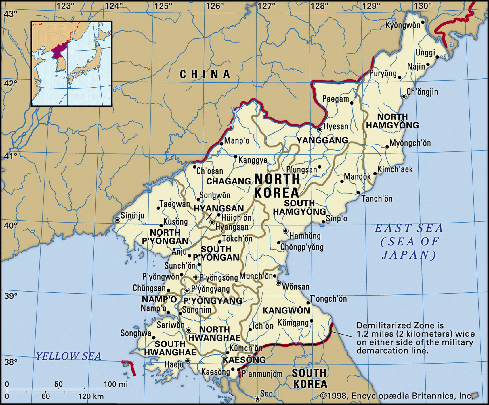
Map of North Korea and geographical facts
North Korea on the world map. Map of North Korea
Map of North Korea with cities. Where North Korea is on the world map. The main geographical facts about North Korea - population, country area, capital, official language, religions, industry and culture.

North Korea Fact File
Official name Democratic People's Republic of Korea
Form of government Communist state with single legislative body (Supreme People's Assembly)
Economy Services and industry 64%, agriculture 36%
Capital P'yongyang
Area 120,540 sq km (46,540 sq miles)
Time zone GMT +9 hours
Population 22,224,000
Projected population 2015 24,396,000
Population density 184.4 per sq km (477.5 per sq mile)
Life expectancy 71.3
Infant mortality (per 1,000) 22.8
Official language Korean
Literacy rate 99 %
Religions Buddhist and Confucian 51 %, traditional beliefs 25%, Christian 4%, other 20%
Ethnic groups Korean 100 %
Currency Won
the border of China. Hundreds of thousands of Chinese "volunteers" poured across the Yalu River into North Korea, and drove the allies far into the south once more. A counter-offensive in 1951 pushed the North Koreans and Chinese troops back to the vicinity of the 38th parallel, where an armistice took place in 1953.
After almost 40 years of tension and a series of minor military clashes a non-aggression pact was negotiated between North and South Korea in 1991. While the war resulted in North Korea becoming a rigid Stalinist state, it also ensured decades of US economic and military protection for South Korea.
For some the war is still not over: in October 1998 a 72-year-old South Korean soldier, who escaped from the north after 45 years as a prisoner-of-war, reported that 30 others like him were still being held in North Korean camps.
GNP per capita US$ 1,000
Climate Temperate, with cold, snowy winters and warm, wet summers
Highest point Mt Paektu 2,744 m (9,003 ft) Map reference Page 208
North Korea occupies the northern half of the Korean Peninsula. It is separated from South Korea along the ceasefire line that was established at the end of the Korean War (1950-53), roughly along the 38th parallel. After a period as an independent kingdom in the tenth century ad, control of Korea was disputed for hundreds of years between China and Japan, the latter seizing it as a colony in 1910. Following the Second World War it became a separate communist state and after the Korean War it developed into a rigidly closed totalitarian state system. The 50-year-long personal rule of Kim II Sung ("Great Leader") passed by hereditary succession to his son Kim Jong II ("Dear Leader") in 1994. The people of North Korea are classed by the state into three quasi-castes: loyal, wavering, and hostile. Membership of a caste determines whether an individual receives either education or employment. Citizens are subject to arbitrary arrest and execution for criticizing the Korean leaders or listening to foreign broadcasts. Unceasing political indoctrination takes place through the media, the workplace, the military, mass spectacles, and cultural events.
Mountains and rugged hills occupy most of the Korean Peninsula, and dominate its northern half. In the northeast the volcanic peak of Mt Paektu is surrounded by the Kaema Plateau. High forested mountains, cut by river gorges, lie along the border with Manchuria, northeast China. Other mountain chains extend north to south along the east coast. The Yalu River valley in the northwest marks the Korean-Chinese border, while to the southwest the fertile Chaeryong and Pyongyang plains are the main areas for agricultural activity. The principal crop is rice, followed by millet and other grains. Fruit and vegetables are grown, as well as oilseed rape, flax, and cotton.
The North Korean economy is run according to the Stalinist model. More than 90 percent of operations are controlled by the state, agriculture is totally collectivized, and state-owned industry produces 95 percent of all manufactured goods. Despite over 50 years of complete control by the state, the country is still not self-sufficient in food. The industrial sector produces military weapons, chemicals, minerals (including coal, magnesite, iron ore, graphite, copper, zinc, lead, and precious metals), along with a number of food products and textiles.
During the late 1990s the economy was in crisis: power supplies were unreliable and food shortages were causing famine in the countryside. Flooding in 1995 damaged harvests and led North Korea to seek foreign aid for the first time in decades; aid donors were muted in their response, demanding proof that aid had been properly distributed. North Korea continues to fall farther behind South Korean development and living standards.
Business street in Taipei, Taiwan (left page bottom). Korean border posts on the 38th parallel (below center).