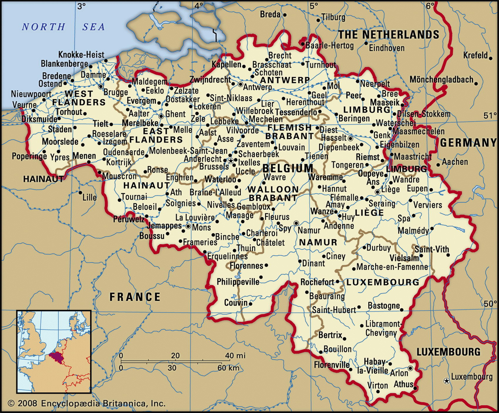
Belgium geographical facts. Map of Belgium with cities
Belgium on Europe map. Geographical facts about Belgium
Map of Belgium with cities and administrative borders. Where Belgium is on the map of Europe.

Belgium Fact File
Official name Kingdom of Belgium
Form of government Federal constitutional monarchy with two legislative bodies (Senate and Chamber of Deputies)
Capital Brussels
Area 30,510 sq km (11,780 sq miles)
Time zone GMT + 1 hour
Population 10,275,000
Projected population 2015 10,272,000
Population density 336.8 per sq km (872.2 per sq mile)
Life expectancy 78.1
Infant mortality (per 1,000) 4.6
Official languages French, Dutch, German
Literacy rate 98 %
Religions Roman Catholic 75%, Protestant or other 25 %
Ethnic groups Fleming 55%, Walloon 33%, other 12 %
Currency Euro
Economy Services 77%, industry 20%, agriculture 3%
GNP per capita US$ 29,000
Climate Temperate, with mild, wet winters and cool summers
Highest point Mt Botrange 694 m (2,277 ft)
Map reference Pages 288, 291
This small, densely populated country has a 60 km (40 mile) coastline on the North Sea and is bounded by France to the west and south, Luxembourg at its southeastern corner, Germany to the east, and the Netherlands to the north. Its name derives from the Belgae, the Gallic race that occupied the area when invading Roman armies arrived in the first century вс. Over more than 2,000 years the region has been dominated by a succession of foreign powers, which explains Belgium's linguistic diversity. From the eighteenth century, Belgium was ruled by Austria, France, then the Netherlands. In 1830 the Belgians declared their independence and installed Leopold I, a relative of the future English Queen Victoria, as their king. Today the country is a parliamentary democracy with a monarch as head of state.
Belgium's population is divided into two main groups. The larger group, the Flemings, lives mostly in the north of the country and speaks Flemish, which is closely related to Dutch. The south is inhabited by the French-speaking Walloons. There is also a German-speaking community to the east of the city of Liege. Brussels, the capital, is officially bilingual. It is the headquarters of the European Union and the North Atlantic Treaty Organization, NATO. Due to the large variety of organizations headquartered here, Brussels is occasionally called the secret capital of Europe. It is one of the most important service centers of Western Europe and is also the home of many banking and insurance firms.
Inland of the beaches and sand dunes along the North Sea lies a narrow strip of drained, reclaimed marshland, intespersed with dikes and traversed by canals. This region gives way to a central, fertile low-lying plain that rises to a low plateau north of the Meuse-Sambre river system. South of these rivers lie Belgium's uplands. In this rugged, sparsely populated area there are a number of mountain ranges, the most extensive of which is the Ardennes. This heavily wooded high plateau of sandstone and shale is punctuated by flat-topped peaks and cut by deep chasms and valleys. Forestry is the main industry in this southern region, where oak and beech trees predominate. Coal mining, once important around the city of Charleroi in the south of Belgium, is now declining.
Belgium's agriculture is centered on its rich northern plain, where crops are secondary to livestock rearing. Although about half the land area has been cleared for agriculture, its contribution to the economy is not significant. Sugar beet, potatoes, wheat, and barley are the main crops and livestock consists largely of pigs and cattle.
Belgium is a heavily industrialized country and its population is highly urbanized. Except for coal, it is poor in natural resources and relies heavily on imported raw materials to fuel its industries. Almost all the industrial centers are in the Flemish area in the north of the country. Antwerp, Europe's third-largest port and the most populous city in Belgium handles the largest part of the country's imports and exports, and it is the center of numerous heavy industries including petroleum refining, plastics, petrochemicals, and heavy machinery manufacture. The manufacture of textiles is particularly associated with the cities of Ghent and Bruges. Iron and steel making, food processing, and glass manufacture are some of the other important industries.
Many of the major industrial centers are connected by a network of canals, along which barges transport cargo. One of the most celebrated of these is the Albert Canal, which links Liege with Antwerp.
While heavy industry has contributed significantly to Belgium's export earnings, it has had a decidedly negative impact on the environment. The Meuse River, which is a major source of drinking water, has been severely polluted by industrial wastes and fertilizers. The acid rain that falls on Belgium and its neighboring countries has been attributed largely to the air pollution that is caused by Belgian industry.
Approximately seventy-five percent of the population are Roman Catholic. There also are Protestant congregations as well as quite a number of Jews. The social security system in Belgium is exemplary. As a consequence, the average life expectancy is one of the highest in Europe.
The historic city of Bruges in Belgium (above left). Cows grazing in the Belgian countryside (below left). La Roque Gageac, a picturesque town on the slopes of the Dordogne Valley in France (below).